| |
|
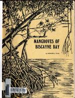 |
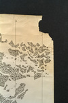
| Mangroves of Biscayne Bay |
|
| Publication Date: | |
1974
|
| Creator: | |
Teas, Howard J. (Howard Jones) 1920-
Metropolitan Dade County (Fla.). Board of County Commissioners ( contributor )
|
| Publisher.Display: | |
Dade County Department of Public Works ( Miami, Florida )
|
| Format: | |
107 pages illustrations (1 folded) 28 cm
|
| Subjects.Display: | |
Mangrove forests -- Florida
Mangrove plants -- Florida
Mangrove swamps -- Florida -- Biscayne Bay
Salt marsh ecology -- Florida -- Biscayne Bay
|
| Source Institution: | |
Florida International University
|
| Donor: | |
W.T. Muir
|
|
| Mangroves of Biscayne Bay |
|
 |
| Manhattan serenade |
|
| Creator: | |
Adamson, Harold ( composer )
Alter, Louis ( composer )
Eberly, Bob ( performer )
Jimmy Dorsey and his Orchestra ( Performer )
|
| Publisher.Display: | |
Decca
|
| Format: | |
1 sound disc : 78 rpm ; 10 in.
|
| Source Institution: | |
Florida International University
|
| Donor: | |
Cristobal Diaz Ayala
|
|
| Manhattan serenade |
|
|
 |
| Manigat. Day of the res. |
|
| Publication Date: | |
1988-06-07
|
| Format: | |
Cassette, Sony HF60
|
| Source Institution: | |
Florida International University
|
| Donor: | |
Diederich, Bernard
|
|
| Manigat. Day of the res. |
|
 |
| Manley Closing Rally |
|
| Publication Date: | |
1989-02-07
|
| Format: | |
Cassette, TDK D-90
|
| Source Institution: | |
Florida International University
|
| Donor: | |
Diederich, Bernard
|
|
| Manley Closing Rally |
|
|
 |
| Manley. End of Press Conference |
|
| Publication Date: | |
2019-02-02
|
| Format: | |
Cassette, Sony HF-S90
|
| Source Institution: | |
Florida International University
|
| Donor: | |
Diederich, Bernard
|
|
| Manley. End of Press Conference |
|
|
| Manolito DIaz |
|
| Publication Date: | |
1975
|
| Creator: | |
Diaz Rodriguez, M. ( Composer )
Gomez, Luiz ( Composer )
Diaz Manuel ( Composer )
Almagro, F. ( Composer )
Aguayo, J. ( Composer )
Martinez Remis, M. ( Composer )
Almagro Herrera, F. ( Composer )
Valero Pirez, A. ( Composer )
Mejias Castilla, Luis ( Composer )
Diaz, Manolito ( Performer )
|
| Publisher.Display: | |
Philips
|
| Format: | |
1 sound disc : 33 1/3 rpm ; 12 in.
|
| Source Institution: | |
Florida International University
|
| Donor: | |
Jaime Canaves
|
|
| Manolito DIaz |
|
|
|
| Manolo boxeador |
|
| Creator: | |
Diaz Rodriguez, M. ( Composer )
Martinez Remis, M. ( Composer )
Almagro Herrera, F. ( Composer )
Valero Pirez, A. ( Composer )
Mejias Castilla, Luis ( Composer )
Diaz, Manolito ( Performer )
|
| Publisher.Display: | |
Philips
|
| Format: | |
1 sound disc : 78 rpm ; 12 in.
|
| Source Institution: | |
Florida International University
|
| Donor: | |
Jaime Canaves
|
|
| Manolo boxeador |
|
 |
| Manolo Ray : personal interviews. Part 2 of 2 |
|
| Publication Date: | |
1994-07
|
| Creator: | |
Florida International University Cuban Living History Project
Gonzalez Pando, Miguel ( Interviewer )
Ray, Manolo ( Interviewee )
Franqui, Carlos ( Interviewee )
|
| Format: | |
on 1 videocassette (40 min.) : sd., col. ; 1/2 in. VHS format. Tape no. VHS464.
|
| Subjects.Display: | |
Cuban exiles oral history
|
| Source Institution: | |
Florida International University
|
|
Manolo Ray : personal interviews. Part 2 of 2
( 2 volumes ) |
|
|
 |
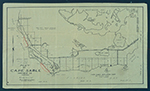
| Manor Place, Coral Gables, Florida |
|
| Publication Date: | |
1949
|
| Creator: | |
Kerdyk Realty ( Contributor )
|
| Format: | |
4 x 6 in
|
| Subjects.Display: | |
Coral Gables (Fla.)--History--Pictorial works
Dwellings--Florida--Coral Gables
Architecture, Domestic--Florida--Coral Gables
|
| Source Institution: | |
Florida International University
|
|
| Manor Place, Coral Gables, Florida |
|
 |
| A man's religion revolves around his "ultimate concern" |
|
| Publication Date: | |
1967
|
| Creator: | |
Baumgard, Herbert M. (1920-2016)
|
| Subjects.Display: | |
Rosh ha-Shanah
Beth Am
Jewish sermons
|
| Source Institution: | |
Florida International University
|
| Donor: | |
Baumgard Family
|
|
| A man's religion revolves around his "ultimate concern" |
|
|
 |
| Mantua Avenue, Coral Gables, Florida |
|
| Publication Date: | |
1949
|
| Creator: | |
Kerdyk Realty ( Contributor )
|
| Format: | |
4 x 6 in
|
| Subjects.Display: | |
Coral Gables (Fla.)--History--Pictorial works
Dwellings--Florida--Coral Gables
Architecture, Domestic--Florida--Coral Gables
|
| Source Institution: | |
Florida International University
|
|
| Mantua Avenue, Coral Gables, Florida |
|
 |
| Manual on flood preparedness program for provincial and district level authorities in the Lower Mekong Basin countries |
|
| Publication Date: | |
2006
|
| Creator: | |
Disaster Risk Reduction Program, Florida International University (DRR/FIU) ( summary contributor )
Flood Managment and Mitigation Program (FMMP)
Mekong River Commission for Sustainable Development (MRC)
|
| Publisher.Display: | |
Asian Disaster Preparedness Center (ADPC)
Deutsche Gesellschaft für Internationale Zusammenarbeit (GIZ)
European Commission Humanitarian Aid and Civil Protection DG (ECHO)
Mekong River Commission for Sustainable Development (MRC)
|
| Subjects.Display: | |
Risk management
Natural hazards and disasters -- Floods
Urban development
|
| Source Institution: | |
Florida International University
|
|
| Manual on flood preparedness program for provincial and district level authorities in the Lower Mekong Basin countries |
|
|
 |
| Manual on guidelines for rehabilitation of coastal forests damaged by natural hazards in the Asia-Pacific region |
|
| Publication Date: | |
2009
|
| Creator: | |
Disaster Risk Reduction Program, Florida International University (DRR/FIU) ( summary contributor )
Chan, H. T.
Baba, S.
|
| Publisher.Display: | |
International Society for Mangrove Ecosystems (ISME)
International Tropical Timber Organization (ITTO)
|
| Subjects.Display: | |
Natural hazards and disasters -- Asia-Pacific
Coastal forests -- Asia-Pacific
Mangrove forests -- Asia-Pacific
Risk management -- Asia-Pacific
|
| Source Institution: | |
Florida International University
|
|
| Manual on guidelines for rehabilitation of coastal forests damaged by natural hazards in the Asia-Pacific region |
|
 |
| Manual on retrofitting of existing vulnerable school buildings - assessment to retrofitting |
|
| Publication Date: | |
2009
|
| Creator: | |
Disaster Risk Reduction Program, Florida International University (DRR/FIU) ( summary contributor )
Darshan Shrestha, Hari
Pribadi, Krishna S.
Kusumastuti, Dyah
Lim, Edwin
|
| Publisher.Display: | |
Save the Children, Construction Quality & Technical Assistance (CQTA)
|
| Subjects.Display: | |
School buildings -- Indonesia
Risk management -- Indonesia
Risk assessment -- Indonesia
School safety and security -- Indonesia
Structural stability -- Indonesia
|
| Source Institution: | |
Florida International University
|
|
| Manual on retrofitting of existing vulnerable school buildings - assessment to retrofitting |
|
|
 |
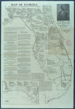
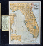
| Map and Seal of Florida |
|
| Publication Date: | |
1908
|
| Publisher.Display: | |
Emanuel Co.
|
| Subjects.Display: | |
Florida
Florida-Maps
|
| Source Institution: | |
Florida International University
|
|
| Map and Seal of Florida |
|
 |
| Map made for the U.S. Coast and Geodetic Survey of Cape Sable : East Cape to Shark River, April 12, 1928 |
|
| Publication Date: | |
1928
|
| Creator: | |
U.S. Coast and Geodetic Survey.
Reading, O. S. ( contributor )
|
| Format: | |
1 map
|
| Subjects.Display: | |
Everglades (Fla.)--Maps.
Sable, Cape (Fla.)--Maps.
Shark River (Fla.)--Maps.
Whitewater Bay (Fla.)--Maps.
|
| Source Institution: | |
Florida International University
|
|
| Map made for the U.S. Coast and Geodetic Survey of Cape Sable : East Cape to Shark River, April 12, 1928 |
|
|
 |
| Map of Cape Sable. |
|
| Creator: | |
Model Land Company.
|
| Format: | |
1 item.
|
| Subjects.Display: | |
Sable, Cape (Fla.)--Maps.
|
| Source Institution: | |
Florida International University
|
|
| Map of Cape Sable. |
|
 |
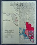
| Map of Florida |
|
| Publication Date: | |
1910
|
| Creator: | |
Moore-Willson, Minnie, b. 1863. ( Contributor )
|
| Format: | |
1 map. : ill.
|
| Subjects.Display: | |
Drainage--Florida--Everglades.
Everglades (Fla.)--Maps.
Broward, Napoleon Bonaparte,--1857-1910.
Florida--Maps.
|
| Source Institution: | |
Florida International University
|
|
| Map of Florida |
|
|
 |
| Map of Florida 500,000 acres choice prairie farming lands in Florida. |
|
| Creator: | |
Moore-Willson, Minnie, b. 1863. ( Contributor )
Southern Colonization Company.
|
| Publisher.Display: | |
Southern Colonization Company
|
| Format: | |
1 map.
|
| Subjects.Display: | |
Everglades (Fla.)--Maps.
Real estate development--Florida--Everglades.
Florida--Maps.
|
| Source Institution: | |
Florida International University
|
|
| Map of Florida 500,000 acres choice prairie farming lands in Florida. |
|
 |
| Map of Florida showing routes and railroad connections. |
|
| Publication Date: | |
1903
|
| Creator: | |
Moore-Willson, Minnie, b. 1863. ( Contributor )
Clyde Steamship Company.
|
| Publisher.Display: | |
C. S. Hammond & Co., ( New York : )
|
| Format: | |
1 map.
|
| Subjects.Display: | |
Florida--Maps.
|
| Source Institution: | |
Florida International University
|
|
| Map of Florida showing routes and railroad connections. |
|

