|
|
|
|
   |
Go to thumbnail:
|
|
|
|
|
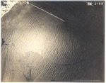
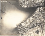
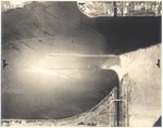
| Photograph, recto: [Aerial view of ocean at an unidentified location] |
|
| Photograph, recto: Aerial Survey Map Abrams Aerial Survey Corp. Lansing, Michigan |
|
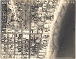
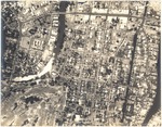
| Photograph, recto: [Aerial view of oceanfront buildings and hotels, Lincoln Road and Washington Ave] |
|
| Photograph, recto: Aerial Survey Map Abrams Aerial Survey Corp. Lansing, Michigan |
|
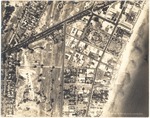
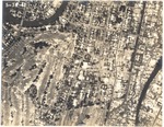
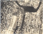
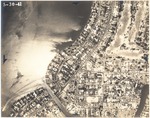
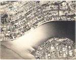
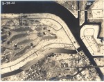
| Photograph, recto: [View of Collins Canal, old Municipal Golf Course and oceanfront hotels and buildings] |
|
| Photograph, recto: Aerial Survey Map Abrams Aerial Survey Corp. Lansing, Michigan |
|
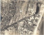
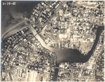
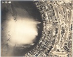
| Photograph, recto: [View of Collins Canal, Lake Pancoast and oceanfront hotels and buildings] |
|
| Photograph, recto: Aerial Survey Map Abrams Aerial Survey Corp. Lansing, Michigan |
|
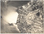
| Photograph, recto: [View of Lake Pancoast and golf courses to the right] |
|
| Photograph, recto: Aerial Survey Map Abrams Aerial Survey Corp. Lansing, Michigan |
|
| Photograph, recto: [Aerial view of polo fields being subdivided] |
|
| Photograph, recto: Aerial Survey Map Abrams Aerial Survey Corp. Lansing, Michigan |
|
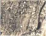
| Photograph, recto: [Aerial view around the St. Patrick's Church, built in 1929] |
|
| Photograph, recto: Aerial Survey Map Abrams Aerial Survey Corp. Lansing, Michigan |
|
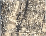
| Photograph, recto: [Aerial view of golf course and Surprise waterway] |
|
| Photograph, recto: Aerial Survey Map Abrams Aerial Survey Corp. Lansing, Michigan |
|
| Photograph, recto: [Aerial view of Surprise Lake] |
|
| Photograph, recto: Aerial Survey Map Abrams Aerial Survey Corp. Lansing, Michigan |
|
| Photograph, recto: [Aerial view of Surprise Lake, Carl Fisher Estate, Carl Fisher Memorial (built in 1941) and King Cole Hotel] |
|
| Photograph, recto: Aerial Survey Map Abrams Aerial Survey Corp. Lansing, Michigan |
|
| Photograph, recto: [Aerial view of the Carl Fisher Estate and Carl Fisher Memorial (built in 1941)] |
|
| Photograph, recto: Aerial Survey Map Abrams Aerial Survey Corp. Lansing, Michigan |
|
| Photograph, recto: [Aerial view of the bay by the La Gorce golf course] |

|
| Photograph, recto: Aerial Survey Map Abrams Aerial Survey Corp. Lansing, Michigan |
|
| Photograph, recto: [Aerial view of the bay north of the La Gorce golf course] |
|
| Photograph, recto: Aerial Survey Map Abrams Aerial Survey Corp. Lansing, Michigan |

|
| Photograph, recto: [Aerial view of the bay north of the La Gorce golf course] |
|
| Photograph, recto: Aerial Survey Map Abrams Aerial Survey Corp. Lansing, Michigan |
|
| Photograph, recto: [Aerial view of the bay north of the La Gorce golf course and south of La Gorce Island] |
|
| Photograph, recto: Aerial Survey Map Abrams Aerial Survey Corp. Lansing, Michigan |

|
| Photograph, recto: [View of the La Gorce Island] |
|
| Photograph, recto: Aerial Survey Map Abrams Aerial Survey Corp. Lansing, Michigan |
|
| Photograph, recto: [View of the La Gorce Island and south of Normandy Isle] |
|
| Photograph, recto: Aerial Survey Map Abrams Aerial Survey Corp. Lansing, Michigan |

|
| Photograph, recto: [Aerial view of Normandy Isle] |
|
| Photograph, recto: Aerial Survey Map Abrams Aerial Survey Corp. Lansing, Michigan |
|
| Photograph, recto: [Aerial view of Normandy Isle] |
|
| Photograph, recto: Aerial Survey Map Abrams Aerial Survey Corp. Lansing, Michigan |
|
| Photograph, recto: [Aerial view of Normandy Isle and Biscayne Point] |
|
| Photograph, recto: Aerial Survey Map Abrams Aerial Survey Corp. Lansing, Michigan |
|
| Photograph, recto: [Aerial view of Biscayne Point] |
|
| Photograph, recto: Aerial Survey Map Abrams Aerial Survey Corp. Lansing, Michigan |
|
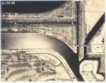
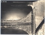
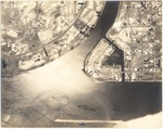
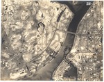
| Photograph, recto: [Aerial view of Government Cut] |
|
| Photograph, recto: Aerial Survey Map Abrams Aerial Survey Corp. Lansing, Michigan |
|
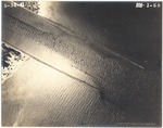
| Photograph, recto: [Aerial view south of Biscaya Island] |
|
| Photograph, recto: Aerial Survey Map Abrams Aerial Survey Corp. Lansing, Michigan |
|
| Photograph, recto: [Aerial view of Biscaya Island] |
|
| Photograph, recto: Aerial Survey Map Abrams Aerial Survey Corp. Lansing, Michigan |
|
| Photograph, recto: [Aerial view of Indian Creek Village and Biscaya Island] |
|
| Photograph, recto: Aerial Survey Map Abrams Aerial Survey Corp. Lansing, Michigan |
|
|
|
|


