|
|
|
|
   |
Go to thumbnail:
|
|
|
|
|
| Photograph, recto: [Aerial view of Indian Creek Village and Bay Harbor Islands] |
|
| Photograph, recto: Aerial Survey Map Abrams Aerial Survey Corp. Lansing, Michigan |
|
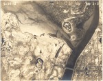
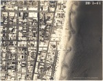
| Photograph, recto: [Aerial view of Government Cut] |
|
| Photograph, recto: Aerial Survey Map Abrams Aerial Survey Corp. Lansing, Michigan |
|
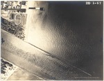
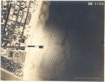
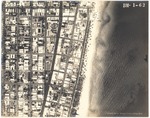
| Photograph, recto: [Aerial view of Government Cut to Third Street] |
|
| Photograph, recto: Aerial Survey Map Abrams Aerial Survey Corp. Lansing, Michigan |
|
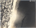
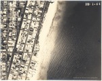
| Photograph, recto: [Aerial view of oceanfront buildings between Third to Seventh Streets] |
|
| Photograph, recto: Aerial Survey Map Abrams Aerial Survey Corp. Lansing, Michigan |
|
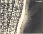
| Photograph, recto: [Aerial view of oceanfront buildings between Seventh and Ninth Streets] |
|
| Photograph, recto: Aerial Survey Map Abrams Aerial Survey Corp. Lansing, Michigan |
|
| Photograph, recto: [Aerial view of oceanfront buildings between Ninth and Eleventh Streets] |
|
| Photograph, recto: Aerial Survey Map Abrams Aerial Survey Corp. Lansing, Michigan |
|
| Photograph, recto: [Aerial view of oceanfront buildings between Eleventh and Fifteenth Streets] |
|
| Photograph, recto: Aerial Survey Map Abrams Aerial Survey Corp. Lansing, Michigan |
|
| Photograph, recto: [Aerial view of oceanfront buildings between Fifteenth Street and Lincoln Road] |
|
| Photograph, recto: Aerial Survey Map Abrams Aerial Survey Corp. Lansing, Michigan |
|
|
|
|


