|
|
| |
|
 |
| Historic Panoramic Photographs of St. Augustine, FL |
|
| Publisher.Display: | |
St. Augustine Restoration, Inc.
|
| Source Institution: | |
University of Florida
|
|
| Historic Panoramic Photographs of St. Augustine, FL |
|
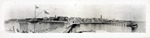 |
| A panoramic view of the historic bayfront from the end of the dock at Capo's Bath House, looking West, ca. 1900 |
|
| Publisher.Display: | |
St. Augustine Restoration, Inc.
|
| Source Institution: | |
University of Florida
|
|
| A panoramic view of the historic bayfront from the end of the dock at Capo's Bath House, looking West, ca. 1900 |
|
|
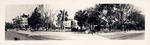 |
| A panoramic view of the Governor's House Garden (lot to the west of Government House) from King Street with the Hotel Ponce de Leon on the far left and the Government House on the far right, looking North, ca. 1910 |
|
| Publisher.Display: | |
St. Augustine Restoration, Inc.
|
| Source Institution: | |
University of Florida
|
|
| A panoramic view of the Governor's House Garden (lot to the west of Government House) from King Street with the Hotel Ponce de Leon on the far left and the Government House on the far right, looking North, ca. 1910 |
|
 |
| A panoramic view of the properties adjacent the Castillo de San Marcos along San Marco Avenue (sometimes referred to as Fort Circle), with the Castillo parking lot on the far left and the City Gates on the far right, looking Southwest, ca. 1965 |
|
| Publisher.Display: | |
St. Augustine Restoration, Inc.
|
| Source Institution: | |
University of Florida
|
|
| A panoramic view of the properties adjacent the Castillo de San Marcos along San Marco Avenue (sometimes referred to as Fort Circle), with the Castillo parking lot on the far left and the City Gates on the far right, looking Southwest, ca. 1965 |
|
|

