| |
|
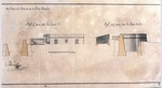 |
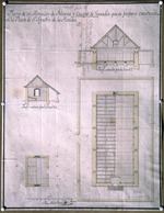
| Del Plano del Reducto de la Isla Amelia |
|
| Creator: | |
Pedro Díaz Berrío
|
| Format: | |
map
|
| Subjects.Display: | |
Profile
|
| Source Institution: | |
University of Florida
|
|
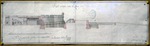
| Del Plano del Reducto de la Isla Amelia |
|
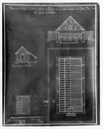
![Elevacion, Vista, y Perfil que pasa por la Linea 1.2.3. [plan of barracks]](http://dpanther.fiu.edu/sobek/content/US/AC/H0/02/93/00001/USACH00293_00001_00001thm.jpg) |
| Elevacion, Vista, y Perfil que pasa por la Linea 1.2.3. [plan of barracks] |
|
| Creator: | |
Mariano de la Rocque
|
| Format: | |
map
|
| Subjects.Display: | |
Profile
|
| Source Institution: | |
University of Florida
|
|
| Elevacion, Vista, y Perfil que pasa por la Linea 1.2.3. [plan of barracks] |
|
|
 |
| Fort of San Agustin, Florida |
|
| Creator: | |
Anon.
|
| Format: | |
map
|
| Subjects.Display: | |
Plan and Profile
|
| Source Institution: | |
University of Florida
|
|
| Fort of San Agustin, Florida |
|
 |
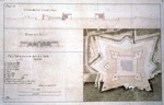
| Fort of San Marcos de Apalache, 1791 |
|
| Creator: | |
Luis de Bertucat
|
| Format: | |
map
|
| Subjects.Display: | |
Plan and Profile
|
| Source Institution: | |
University of Florida
|
|
| Fort of San Marcos de Apalache, 1791 |
|
|
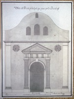 |
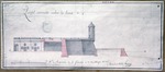
| Front View of the Parochial Church |
|
| Creator: | |
Mariano de la Rocque
|
| Format: | |
map
|
| Subjects.Display: | |
Profile
|
| Source Institution: | |
University of Florida
|
|
| Front View of the Parochial Church |
|
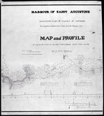 |
| Harbour of Saint Augustine |
|
| Creator: | |
Lt. Col. P. H. Perrault
[Drawn by] Lt. Jefferson Vail ( contributor )
|
| Format: | |
map
|
| Subjects.Display: | |
Survey and Profile
|
| Source Institution: | |
University of Florida
|
|
| Harbour of Saint Augustine |
|
|
 |
| Perfil Cortado Sobre La Linea 1-2, Pertenece al Castillo de San Marcos |
|
| Creator: | |
Mariano de la Rocque
|
| Format: | |
map
|
| Subjects.Display: | |
Profile
|
| Source Institution: | |
University of Florida
|
|
| Perfil Cortado Sobre La Linea 1-2, Pertenece al Castillo de San Marcos |
|
 |
| Perfil Cortado Sobre La Linea 3-4, Pertenece al Castillo de San Marcos |
|
| Creator: | |
Mariano de la Rocque
|
| Format: | |
map
|
| Subjects.Display: | |
Profile
|
| Source Institution: | |
University of Florida
|
|
| Perfil Cortado Sobre La Linea 3-4, Pertenece al Castillo de San Marcos |
|
|
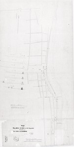 |
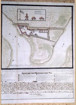
| Plan of Sea Wall St. Augustine with Parts of the City and Harbor |
|
| Creator: | |
F. L. Dancy
|
| Format: | |
map
|
| Subjects.Display: | |
Plan and Profile
|
| Source Institution: | |
University of Florida
|
|
| Plan of Sea Wall St. Augustine with Parts of the City and Harbor |
|
 |
| Plano de un Almacen de Polvora Y Cuerpo de Guardia que se Propone Construir en la Plaza de San Agustin de la Florida |
|
| Creator: | |
Pedro Díaz Berrío
|
| Format: | |
map
|
| Subjects.Display: | |
Plan and Profile
|
| Source Institution: | |
University of Florida
|
|
| Plano de un Almacen de Polvora Y Cuerpo de Guardia que se Propone Construir en la Plaza de San Agustin de la Florida |
|
|
 |
| Plano de un Almacen de Polvora Y Cuerpo de Guardia que se Propone Construir en la Plaza de San Agustin de la Florida, Francisco Sabatine (Negative) |
|
| Creator: | |
Pedro Díaz Berrío
[Copyist] Francisco Sabatine [or] Josef la Puente ( contributor )
|
| Format: | |
map
|
| Subjects.Display: | |
Plan and Profile
|
| Source Institution: | |
University of Florida
|
|
Plano de un Almacen de Polvora Y Cuerpo de Guardia que se Propone Construir en la Plaza de San Agustin de la Florida, Francisco Sabatine (Negative)
( 2 volumes ) |
|
 |
| Plano del Castillo de San Marcos en San Agustin de La Florida Oriental, 1817 |
|
| Creator: | |
D. Francisco Cortazar
[Copyist] Antonio M. de la Torre y Cardenas ( contributor )
|
| Format: | |
map
|
| Subjects.Display: | |
Plan and Profile
|
| Source Institution: | |
University of Florida
|
|
| Plano del Castillo de San Marcos en San Agustin de La Florida Oriental, 1817 |
|
|
 |
| Profiles of fort of San Agustin, Florida |
|
| Creator: | |
Anon.
|
| Format: | |
map
|
| Subjects.Display: | |
Profile
|
| Source Institution: | |
University of Florida
|
|
| Profiles of fort of San Agustin, Florida |
|
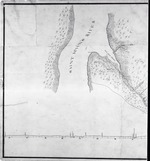 |
| St. Johns River, Six Mile Creek Blowup (Part of Canal Plan) |
|
| Creator: | |
Lt. Col. P. H. Perrault
[Drawn by] Lt. Jefferson Vail ( contributor )
|
| Format: | |
map
|
| Subjects.Display: | |
Survey and Profile
|
| Source Institution: | |
University of Florida
|
|
| St. Johns River, Six Mile Creek Blowup (Part of Canal Plan) |
|
|
 |
| Survey of the Sea Wall of St. Augustine with City Proper and the Adjacent Shore |
|
| Creator: | |
H. W. Benham
|
| Format: | |
map
|
| Subjects.Display: | |
Plan and Profile
|
| Source Institution: | |
University of Florida
|
|
| Survey of the Sea Wall of St. Augustine with City Proper and the Adjacent Shore |
|
 |
| View and Elevation with verticle outline of the parochial church of San Agustin |
|
| Creator: | |
Mariano de la Rocque
|
| Format: | |
map
|
| Subjects.Display: | |
Profile
|
| Source Institution: | |
University of Florida
|
|
| View and Elevation with verticle outline of the parochial church of San Agustin |
|

