|
|
| |
|
 |
| The Coast of West Florida and Louisiana |
|
| Creator: | |
Thomas Jefferys
|
| Format: | |
map
|
| Subjects.Display: | |
Map
|
| Source Institution: | |
University of Florida
|
|
| The Coast of West Florida and Louisiana |
|
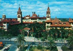 |
| Hotel Ponce de Leon from the roof of the Alcazar, looking North (ca. early 1960s) |
|
| Publisher.Display: | |
St. Augustine Restoration, Inc.
|
| Subjects.Display: | |
Saint Augustine (Fla.)
74 King Street Street (Saint Augustine, Fla.)
Hotel Ponce de Leon (Saint Augustine, Fla.)
Flagler College (Saint Augustine, Fla.)
|
| Source Institution: | |
University of Florida
|
|
Hotel Ponce de Leon from the roof of the Alcazar, looking North (ca. early 1960s)
( 8 volumes ) |
|
|
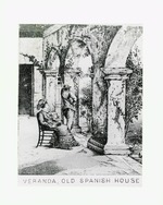 |
| Illustration of a man and woman seated on the loggia/veranda of the Segui House, 1890 |
|
| Publication Date: | |
1890
|
| Creator: | |
Thomas Tugby
|
| Publisher.Display: | |
Thomas Tugby
|
| Subjects.Display: | |
Saint Augustine, Fla.
12 Aviles Street (Saint Augustine, Fla.)
Segui House (Saint Augustine, Fla.)
Public Library (Saint Augustine, Fla.)
Saint Augustine Historical Society Library (Saint Augustine, Fla.)
|
| Source Institution: | |
University of Florida
|
|
| Illustration of a man and woman seated on the loggia/veranda of the Segui House, 1890 |
|
|
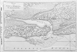
| Map of St. Augustine from Cathedral St. to Orange St., Cordove to Matanzas River |
|
| Creator: | |
Lester Thomas
|
| Format: | |
map
|
| Subjects.Display: | |
Plan
|
| Source Institution: | |
University of Florida
|
|
| Map of St. Augustine from Cathedral St. to Orange St., Cordove to Matanzas River |
|
|
|
| A New and Accurate Map of East and West Florida Drawn from the Best Authorities |
|
| Creator: | |
Thomas Kitchen
|
| Source Institution: | |
University of Florida
|
|
| A New and Accurate Map of East and West Florida Drawn from the Best Authorities |
|
|
| The Peninsula and Gulf of Florida, or New Bahama Channel, with the Bahama Islands |
|
| Creator: | |
Thomas Jefferys
|
| Format: | |
map
|
| Subjects.Display: | |
Map
|
| Source Institution: | |
University of Florida
|
|
| The Peninsula and Gulf of Florida, or New Bahama Channel, with the Bahama Islands |
|
|
 |
| Plan of the Town and Harbour of St. Augustine |
|
| Creator: | |
Thomas Jefferys
|
| Format: | |
map
|
| Subjects.Display: | |
Plan
|
| Source Institution: | |
University of Florida
|
|
| Plan of the Town and Harbour of St. Augustine |
|
|
| San Marco Lot |
|
| Creator: | |
Lester Thomas
|
| Format: | |
map
|
| Source Institution: | |
University of Florida
|
|
| San Marco Lot |
|
|
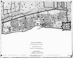 |
| St. Augustine the Capital of East Florida |
|
| Creator: | |
Thomas Jefferys
|
| Format: | |
map
|
| Subjects.Display: | |
Plan
|
| Source Institution: | |
University of Florida
|
|
| St. Augustine the Capital of East Florida |
|
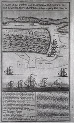 |
| A View of the Town and Castle of St. Augustine and the English Camp Before June 20, 1740 |
|
| Creator: | |
Thomas Silver
|
| Format: | |
map
|
| Subjects.Display: | |
Plan
|
| Source Institution: | |
University of Florida
|
|
| A View of the Town and Castle of St. Augustine and the English Camp Before June 20, 1740 |
|
|

