| |
|
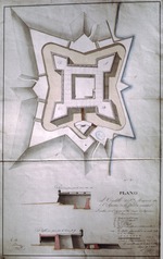 |
| Plano del Castillo de San Marcos en San Agustin de La Florida Oriental, 1817 |
|
|
| Plano del Castillo de San Marcos en San Agustin de La Florida Oriental, 1817 |
|
 |
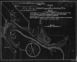
| St. Augustine Harbor (Part of Canal Plan) |
|
|
| St. Augustine Harbor (Part of Canal Plan) |
|
|
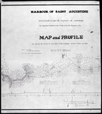 |
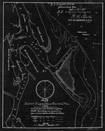
| Harbour of Saint Augustine |
|
|
| Harbour of Saint Augustine |
|
 |
| Plan of City of St. Augustine copied from a drawing made in 1831 |
|
|
| Plan of City of St. Augustine copied from a drawing made in 1831 |
|
|
 |
| Copy of a Plan of the City of St. Augustine, Flora with some additions for the year 1833 |
|
|
| Copy of a Plan of the City of St. Augustine, Flora with some additions for the year 1833 |
|
|
| North America XIV Florida |
|
|
| North America XIV Florida |
|
|
|
|
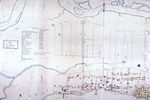
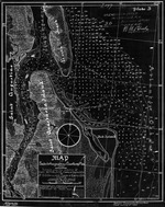
| Land Grants |
|
|
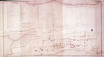
| Plan of the City of St. Augustine |
|
|
| Plan of the City of St. Augustine |
|
|
|
| Map of the City of St. Augustine, East Florida, 1835 |
|
|
| Map of the City of St. Augustine, East Florida, 1835 |
|
 |
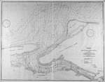
| St. Johns River, Six Mile Creek Blowup (Part of Canal Plan) |
|
|
| St. Johns River, Six Mile Creek Blowup (Part of Canal Plan) |
|
|
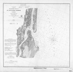 |
| Preliminary Chart of St. Augustine Harbor, ed. #2 |
|
|
| Preliminary Chart of St. Augustine Harbor, ed. #2 |
|
 |
| Map of the City of St. Augustine, East Florida, 1884 |
|
|
| Map of the City of St. Augustine, East Florida, 1884 |
|
|
 |
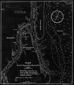
| Map of St. Augustine Harbor |
|
|
| Map of St. Augustine Harbor |
|
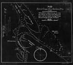 |
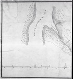
| Map of St. Augustine Harbor (1791) |
|
|
| Map of St. Augustine Harbor (1791) |
|
|
 |
| Map of St. Augustine Harbor (1826) |
|
|
| Map of St. Augustine Harbor (1826) |
|
 |
| Map of St. Augustine Harbor (1862/3) |
|
|
| Map of St. Augustine Harbor (1862/3) |
|
|
 |
| Map of St. Augustine Harbor (1882) |
|
|
| Map of St. Augustine Harbor (1882) |
|
 |
| Map of St. Augustine Harbor (1887) |
|
|
| Map of St. Augustine Harbor (1887) |
|
|
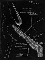 |
| Comparative Sketch of Shore Lines at the Entrance of Saint Augustine Harbor, Fla. |
|
|
| Comparative Sketch of Shore Lines at the Entrance of Saint Augustine Harbor, Fla. |
|
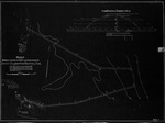 |
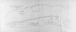
| Sketch showing Proposed Location of Jetties at the Entrance to Saint Augustine Harbor, Fla. |
|
|
| Sketch showing Proposed Location of Jetties at the Entrance to Saint Augustine Harbor, Fla. |
|

