| |
|
 |
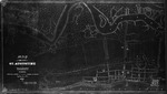
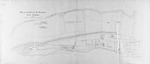
| Map of St. Augustine from Cathedral St. to Orange St., Cordove to Matanzas River |
|
| Creator: | |
Lester Thomas
|
| Format: | |
map
|
| Subjects.Display: | |
Plan
|
| Source Institution: | |
University of Florida
|
|
| Map of St. Augustine from Cathedral St. to Orange St., Cordove to Matanzas River |
|
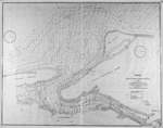 |
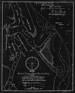
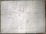
| Map of St. Augustine Harbor |
|
| Creator: | |
W. M. Black
|
| Format: | |
map
|
| Subjects.Display: | |
Coastal chart
|
| Source Institution: | |
University of Florida
|
|
| Map of St. Augustine Harbor |
|
|
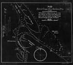 |
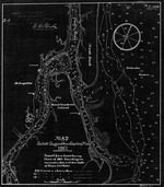
| Map of St. Augustine Harbor (1791) |
|
| Creator: | |
W. M. Black
|
| Format: | |
map
|
| Subjects.Display: | |
Coastal chart
|
| Source Institution: | |
University of Florida
|
|
| Map of St. Augustine Harbor (1791) |
|
 |
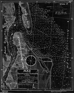
| Map of St. Augustine Harbor (1826) |
|
| Creator: | |
W. M. Black
|
| Format: | |
map
|
| Subjects.Display: | |
Coastal chart
|
| Source Institution: | |
University of Florida
|
|
| Map of St. Augustine Harbor (1826) |
|
|
 |
| Map of St. Augustine Harbor (1862/3) |
|
| Creator: | |
W. M. Black
|
| Format: | |
map
|
| Subjects.Display: | |
Coastal chart
|
| Source Institution: | |
University of Florida
|
|
| Map of St. Augustine Harbor (1862/3) |
|
 |
| Map of St. Augustine Harbor (1882) |
|
| Creator: | |
W. M. Black
|
| Format: | |
map
|
| Subjects.Display: | |
Coastal chart
|
| Source Institution: | |
University of Florida
|
|
| Map of St. Augustine Harbor (1882) |
|
|
 |
| Map of St. Augustine Harbor (1887) |
|
| Creator: | |
W. M. Black
|
| Format: | |
map
|
| Subjects.Display: | |
Coastal chart
|
| Source Institution: | |
University of Florida
|
|
| Map of St. Augustine Harbor (1887) |
|
 |
| Map of the City of St. Augustine & Vicinity, 1863 |
|
| Creator: | |
Col. J. R. Hawley
|
| Format: | |
map
|
| Subjects.Display: | |
Map
|
| Source Institution: | |
University of Florida
|
|
| Map of the City of St. Augustine & Vicinity, 1863 |
|
|
|
| Map of the City of St. Augustine, East Florida, 1835 |
|
| Creator: | |
Benjamin and J. B. Clements
[Copyist] Anon. ( contributor )
|
| Format: | |
map
|
| Subjects.Display: | |
Plan
|
| Source Institution: | |
University of Florida
|
|
| Map of the City of St. Augustine, East Florida, 1835 |
|
 |
| Map of the City of St. Augustine, East Florida, 1884 |
|
| Creator: | |
Anon.
|
| Format: | |
map
|
| Subjects.Display: | |
Survey
|
| Source Institution: | |
University of Florida
|
|
| Map of the City of St. Augustine, East Florida, 1884 |
|
|
|
| Map of the General Surveys of East Florida |
|
| Creator: | |
Wm. Gerard De Brahm
|
| Format: | |
map
|
| Subjects.Display: | |
Map
|
| Source Institution: | |
University of Florida
|
|
| Map of the General Surveys of East Florida |
|
|
| Map of the Gulf of Mexico + the West Indies |
|
| Creator: | |
Pietro Martire d'Anghiera
|
| Format: | |
map
|
| Subjects.Display: | |
Map
|
| Source Institution: | |
University of Florida
|
|
| Map of the Gulf of Mexico + the West Indies |
|
|
 |
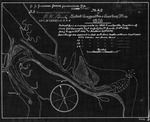
| Map of the Harbor and Bar of San Agustin, located in East Florida |
|
| Creator: | |
Anon.
|
| Format: | |
map
|
| Subjects.Display: | |
Coastal chart
|
| Source Institution: | |
University of Florida
|
|
| Map of the Harbor and Bar of San Agustin, located in East Florida |
|
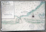 |
| Map of the Harbor Entrance and Harbor of Pensacola |
|
| Creator: | |
Anon.
|
| Format: | |
map
|
| Subjects.Display: | |
Coastal chart
|
| Source Institution: | |
University of Florida
|
|
| Map of the Harbor Entrance and Harbor of Pensacola |
|
|
|
| A Map of the Road from Pensacola in W. Florida to St. Augustine in E. Florida |
|
| Creator: | |
Joseph Purcell
|
| Format: | |
map
|
| Subjects.Display: | |
Map
|
| Source Institution: | |
University of Florida
|
|
| A Map of the Road from Pensacola in W. Florida to St. Augustine in E. Florida |
|
 |
| Map of Town, Fort + Channel of San Augustin |
|
| Creator: | |
Anon.
|
| Format: | |
map
|
| Subjects.Display: | |
Map
|
| Source Institution: | |
University of Florida
|
|
| Map of Town, Fort + Channel of San Augustin |
|
|
|
| Mapa De La Ysla de La Florida |
|
| Creator: | |
Anon.
|
| Format: | |
map
|
| Source Institution: | |
University of Florida
|
|
| Mapa De La Ysla de La Florida |
|
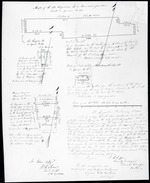 |
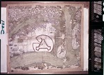
| Maps of the Old Magazine lot or Governors Garden |
|
| Creator: | |
Anon.
|
| Format: | |
map
|
| Subjects.Display: | |
Survey
|
| Source Institution: | |
University of Florida
|
|
| Maps of the Old Magazine lot or Governors Garden |
|
|
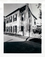 |
| Marin House from Marine Street, looking Northeast |
|
| Publisher.Display: | |
St. Augustine Restoration, Inc.
|
| Source Institution: | |
University of Florida
|
| Donor: | |
Photograph
|
|
Marin House from Marine Street, looking Northeast
( 3 volumes ) |
|
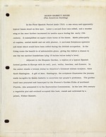 |
| Marin-Hassett House (Pan American Building) |
|
| Publisher.Display: | |
St. Augustine Historical Restoration and Preservation Commission
|
| Source Institution: | |
University of Florida
|
|
Marin-Hassett House (Pan American Building)
( 60 volumes ) |
|

