| |
|
 |
| Hydrodynamic and salinity analysis of a proposed navigation channel in the St. Lucie estuary |
|
| Creator: | |
South Florida Water Management District (Fla.)
Gove, Charles Arthur
1989-06 ( Contributor )
|
| Publisher.Display: | |
South Florida Water Management District, Resource Planning Dept., Water Resources Division ( West Palm Beach, Fla. )
|
| Format: | |
10, [8] p. : ill. ; 28 cm.
|
| Subjects.Display: | |
Martin County (Fla.)
Saint Lucie River (Fla.)
Channels (Hydraulic engineering) -- Environmental aspects -- Computer simulation ( lcsh )
Channels (Hydraulic engineering) -- Environmental aspects ( lcsh )
Salinization -- Control ( lcsh )
|
| Source Institution: | |
Florida International University
|
|
| Hydrodynamic and salinity analysis of a proposed navigation channel in the St. Lucie estuary |
|
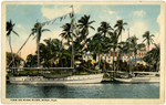 |
| View on Miami River, Miami, Fla |
|
| Publisher.Display: | |
Jacksonville, Florida: H. & W.B. Drew Co.
|
| Subjects.Display: | |
Miami River (Fla.)
|
| Source Institution: | |
Florida International University
|
|
| View on Miami River, Miami, Fla |
|
|
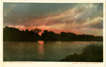 |
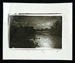
| Sunset on the Miami River, Fla. |
|
| Publisher.Display: | |
Detroit Photographic Co.
|
| Subjects.Display: | |
Miami River (Fla.)
|
| Source Institution: | |
Florida International University
|
|
| Sunset on the Miami River, Fla. |
|
 |
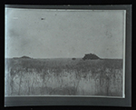
| The mouth of Shark River at Gulf of Mexico Everglades National Park Florida |
|
| Publisher.Display: | |
Unidentified
|
| Subjects.Display: | |
Everglades (Fla.)
Shark River (Florida)
|
| Source Institution: | |
Florida International University
|
|
| The mouth of Shark River at Gulf of Mexico Everglades National Park Florida |
|
|
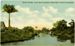 |
| Up in the Everglades, Miami River, head of navigation |
|
| Publisher.Display: | |
Unidentified
|
| Subjects.Display: | |
Everglades (Fla.)
Miami River (Fla.)
|
| Source Institution: | |
Florida International University
|
|
| Up in the Everglades, Miami River, head of navigation |
|
 |
| Rivers that drain the Everglades, circa 1887-1890. |
|
| Creator: | |
Munroe, Ralph, 1851-1933.
|
| Format: | |
2 photos. : black and white.
|
| Subjects.Display: | |
Miami River (Fla.)
Arch Creek (Fla.)
|
| Source Institution: | |
Florida International University
|
|
| Rivers that drain the Everglades, circa 1887-1890. |
|
|
 |
| Photographs in the Everglades, 1800s |
|
| Creator: | |
Munroe, Ralph, 1851-1933.
|
| Format: | |
3 photos. : black and white.
|
| Subjects.Display: | |
Cutler (Fla.)
Little River (Fla.)
|
| Source Institution: | |
Florida International University
|
|
| Photographs in the Everglades, 1800s |
|
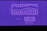 |
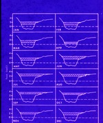
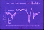
| Turner River studies: highest and lowest water levels for period of record |
|
| Format: | |
1 color 35 mm slide
|
| Subjects.Display: | |
Big Cypress National Preserve (Fla.)
Turner River (Fla.)
|
| Source Institution: | |
FIU Special Collections
|
| Donor: | |
Everglades National Park Library
|
|
| Turner River studies: highest and lowest water levels for period of record |
|
|
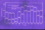 |
| Turner River studies: mean stage |
|
| Format: | |
1 color 35 mm slide
|
| Subjects.Display: | |
Big Cypress National Preserve (Fla.)
Turner River (Fla.)
|
| Source Institution: | |
FIU Special Collections
|
| Donor: | |
Everglades National Park Library
|
|
| Turner River studies: mean stage |
|
 |
| Turner River studies |
|
| Format: | |
1 color 35 mm slide
|
| Subjects.Display: | |
Big Cypress National Preserve (Fla.)
Turner River (Fla.)
|
| Source Institution: | |
FIU Special Collections
|
| Donor: | |
Everglades National Park Library
|
|
| Turner River studies |
|
|
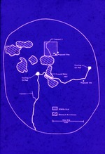 |
| Turner River studies: wildlife grid and research burn areas |
|
| Format: | |
1 color 35 mm slide
|
| Subjects.Display: | |
Big Cypress National Preserve (Fla.)
Turner River (Fla.)
|
| Source Institution: | |
FIU Special Collections
|
| Donor: | |
Everglades National Park Library
|
|
| Turner River studies: wildlife grid and research burn areas |
|
 |
| Turner River studies: Big Cypress National Preserve, forty mile-bend to Monroe, low flow conditions, L28 canal |
|
| Format: | |
1 color 35 mm slide
|
| Subjects.Display: | |
Big Cypress National Preserve (Fla.)
Turner River (Fla.)
|
| Source Institution: | |
FIU Special Collections
|
| Donor: | |
Everglades National Park Library
|
|
| Turner River studies: Big Cypress National Preserve, forty mile-bend to Monroe, low flow conditions, L28 canal |
|
|
 |
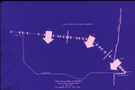
| Turner River studies: Big Cypress National Preserve water quality sampling locations |
|
| Format: | |
1 color 35 mm slide
|
| Subjects.Display: | |
Big Cypress National Preserve (Fla.)
Turner River (Fla.)
|
| Source Institution: | |
FIU Special Collections
|
| Donor: | |
Everglades National Park Library
|
|
| Turner River studies: Big Cypress National Preserve water quality sampling locations |
|
 |
| Turner River studies: mean bedrock elevation and soil surface elevation |
|
| Format: | |
1 color 35 mm slide
|
| Subjects.Display: | |
Big Cypress National Preserve (Fla.)
Turner River (Fla.)
|
| Source Institution: | |
FIU Special Collections
|
| Donor: | |
Everglades National Park Library
|
|
| Turner River studies: mean bedrock elevation and soil surface elevation |
|
|
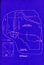 |
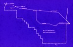
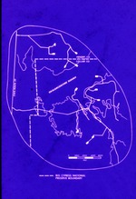
| Turner River studies: Big Cypress National Preserve subbasin boundary and park or preserve boundary |
|
| Format: | |
1 color 35 mm slide
|
| Subjects.Display: | |
Big Cypress National Preserve (Fla.)
Turner River (Fla.)
|
| Source Institution: | |
FIU Special Collections
|
| Donor: | |
Everglades National Park Library
|
|
| Turner River studies: Big Cypress National Preserve subbasin boundary and park or preserve boundary |
|
 |
| Turner River studies: oil and gas development |
|
| Format: | |
1 color 35 mm slide
|
| Subjects.Display: | |
Big Cypress National Preserve (Fla.)
Turner River (Fla.)
|
| Source Institution: | |
FIU Special Collections
|
| Donor: | |
Everglades National Park Library
|
|
| Turner River studies: oil and gas development |
|
|
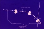 |
| Turner River studies: Big Cypress National Preserve, Forty Mile-Bend to Monroe low flow conditions |
|
| Format: | |
1 color 35 mm slide
|
| Subjects.Display: | |
Big Cypress National Preserve (Fla.)
Turner River (Fla.)
|
| Source Institution: | |
FIU Special Collections
|
| Donor: | |
Everglades National Park Library
|
|
| Turner River studies: Big Cypress National Preserve, Forty Mile-Bend to Monroe low flow conditions |
|
 |
| Turner River studies: canal drawdown effects |
|
| Format: | |
1 color 35 mm slide
|
| Subjects.Display: | |
Big Cypress National Preserve (Fla.)
Turner River (Fla.)
|
| Source Institution: | |
FIU Special Collections
|
| Donor: | |
Everglades National Park Library
|
|
| Turner River studies: canal drawdown effects |
|
|
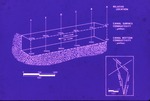 |
| Turner River studies: canal surface conductivity and canal bottom conductivity |
|
| Format: | |
1 color 35 mm slide
|
| Subjects.Display: | |
Big Cypress National Preserve (Fla.)
Turner River (Fla.)
|
| Source Institution: | |
FIU Special Collections
|
| Donor: | |
Everglades National Park Library
|
|
| Turner River studies: canal surface conductivity and canal bottom conductivity |
|
 |
| Turner River studies: Big Cypress National Preserve Okaloacoochee Slough |
|
| Format: | |
1 color 35 mm slide
|
| Subjects.Display: | |
Big Cypress National Preserve (Fla.)
Turner River (Fla.)
|
| Source Institution: | |
FIU Special Collections
|
| Donor: | |
Everglades National Park Library
|
|
| Turner River studies: Big Cypress National Preserve Okaloacoochee Slough |
|

