| |
|
 |
| Little Venice Water Quality Monitoring Quarterly Reports #7 |
|
| Publication Date: | |
2002-12-14
|
| Creator: | |
Joseph N. Boyer
Ronald Jones
|
| Publisher.Display: | |
Florida International University
|
| Subjects.Display: | |
Water quality -- Florida
|
| Source Institution: | |
Florida International University
|
|
| Little Venice Water Quality Monitoring Quarterly Reports #7 |
|
 |
| Loaxahatchee Impoundment Landscape Assessment (LILA): Tree Island Experiments and Management; May 1, 2005 to September 4, 2009: Final Report |
|
| Publication Date: | |
2009-08-17
|
| Creator: | |
Michael Ross
Leonard J. Scinto
René Price
|
| Publisher.Display: | |
Southeast Environmental Research Center, Florida International University ( Miami, Florida )
|
| Format: | |
119 pages
|
| Subjects.Display: | |
Landscape assessment
Landscape evaluation
|
| Source Institution: | |
Added automatically
|
|
| Loaxahatchee Impoundment Landscape Assessment (LILA): Tree Island Experiments and Management; May 1, 2005 to September 4, 2009: Final Report |
|
|
 |
| Loaxahatchee Impoundment Landscape Assessment (LILA): Tree Island Experiments and Management; May 1, 2005 to September 4, 2009: Final Report |
|
| Publication Date: | |
2009-08-17
|
| Creator: | |
Michael Ross
Leonard J. Scinto
René Price
|
| Publisher.Display: | |
Florida International University. Southeast Environmental Research Center
|
| Subjects.Display: | |
Everglades National Park (Fla.)
Tree islands
|
| Source Institution: | |
Florida International University
|
|
| Loaxahatchee Impoundment Landscape Assessment (LILA): Tree Island Experiments and Management; May 1, 2005 to September 4, 2009: Final Report |
|
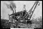 |
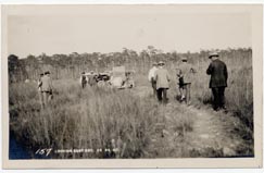
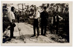
| Logging in the Everglades, ca. 1908-1910. |
|
| Publication Date: | |
1910
|
| Format: | |
2 photos. : black and white.
|
| Subjects.Display: | |
Everglades (Fla.)--Photographs.
Hurst, John.
Hurst, May.
Drake Lumber Company.
Logging--Florida.
Sawmills--Florida.
Miami Shores (Fla.)
Silver Palm (Fla.)
|
| Source Institution: | |
Florida International University
|
|
| Logging in the Everglades, ca. 1908-1910. |
|
|
 |
| Long Term Recovery of Experimental Off-Road Vehicle Impacts and Abandoned Old Trails in the Big Cypress National Preserve |
|
| Publication Date: | |
1986
|
| Creator: | |
Michael J. Duever
Lawrence A. Riopelle
South Florida Natural Resources Center, South Florida Research Center, Everglades National Park
Jean M. McCollom
|
| Publisher.Display: | |
National Park Service, U.S. Department of the Interior ( Homestead, Florida )
|
| Subjects.Display: | |
Ecology
All terrain vehicles
Environmental aspects
Marsh ecology
Big Cypres National Preserve
|
| Source Institution: | |
Florida International University
|
|
| Long Term Recovery of Experimental Off-Road Vehicle Impacts and Abandoned Old Trails in the Big Cypress National Preserve |
|
 |
| Long Term Trends in the Water Quality of Florida Bay (1989-2000) |
|
| Publication Date: | |
2000-01-01
|
| Creator: | |
Joseph N. Boyer
Ronald Jones
|
| Publisher.Display: | |
Florida International University
|
| Subjects.Display: | |
Water Quality -- Florida Bay
|
| Source Institution: | |
Florida International University
|
|
| Long Term Trends in the Water Quality of Florida Bay (1989-2000) |
|
|
 |
| Long Term Trends in the Water Quality of Florida Bay (June 1989-Dec. 1999) |
|
| Publication Date: | |
1999-01-01
|
| Creator: | |
Joseph N. Boyer
Ronald Jones
|
| Publisher.Display: | |
Florida International University
|
| Subjects.Display: | |
Water Quality -- Florida Bay
|
| Source Institution: | |
Florida International University
|
|
| Long Term Trends in the Water Quality of Florida Bay (June 1989-Dec. 1999) |
|
 |
| Long Term Tropical Storm Incidence, |
|
| Publication Date: | |
1982-04
|
| Creator: | |
South Florida Water Management District ( Contributor )
Hamrick, Robert L.
|
| Publisher.Display: | |
South Florida Water Management District
|
| Format: | |
PDF, 19 pages, illustrations, charts, maps
|
| Subjects.Display: | |
South Florida
|
| Source Institution: | |
Florida International University
|
|
| Long Term Tropical Storm Incidence, |
|
|
 |
| Long-term effects of adding nutrients to an oligotrophic coastal environment |
|
| Publication Date: | |
2011
|
| Creator: | |
Armitage, Anna R.
Frankovich, Thomas A.
Fourqurean, James W
|
| Publisher.Display: | |
Florida Coastal Everglades Long Term Ecological Research
|
| Subjects.Display: | |
Seagrasses -- Florida -- Florida Bay
Epiphytes -- Florida -- Florida Bay
Plant nutrients -- Florida -- Florida Bay
Ecological disturbances -- Florida -- Florida Bay
|
| Source Institution: | |
Florida International University
|
|
| Long-term effects of adding nutrients to an oligotrophic coastal environment |
|
 |
| Looking East |
|
| Publication Date: | |
1904/1920
|
| Format: | |
8.8 x 14 cm
|
| Subjects.Display: | |
Everglades (Fla.)
Pioneers
|
| Source Institution: | |
Florida International University
|
|
| Looking East |
|
|
 |
| Looking east |
|
| Publication Date: | |
1904/1920
|
| Format: | |
8.8 x 14.1 cm
|
| Subjects.Display: | |
Everglades (Fla.)
Pioneers
|
| Source Institution: | |
Florida International University
|
|
| Looking east |
|
 |
| Mackerel Workshop report : results of a workshop to examine the Spanish and king mackerel fisheries from the systems viewpoint, held in Miami on April 28 and 29, 1977 |
|
| Publication Date: | |
1978
|
| Creator: | |
C Bruce Austin ( Contributor )
Southeast Fisheries Center (U.S.) ( Contributor )
Rosenstiel School of Marine and Atmospheric Science. ( Contributor )
University of Miami. Sea Grant Program. ( Contributor )
et al ( Contributor )
|
| Publisher.Display: | |
Coral Gables, Fla. : Information Services, Sea Grant, University of Miami , 1978.
|
| Format: | |
Book, Conference publication
|
| Subjects.Display: | |
Mackerel fisheries -- Florida -- Congresses.
Mackerel fishing -- Florida -- Congresses.
King mackerel -- Congresses.
Spanish mackerel -- Congresses.
Fishery management -- Florida -- Congresses.
|
| Source Institution: | |
Florida International University
|
|
| Mackerel Workshop report : results of a workshop to examine the Spanish and king mackerel fisheries from the systems viewpoint, held in Miami on April 28 and 29, 1977 |
|
|
 |
| Macro Invertebrate Responses to Phosphorus Enrichment in the Northern (WCA-2A) Everglades |
|
| Publication Date: | |
2001-03
|
| Creator: | |
McCormick, Paul
Shuford, Robert B.E. III
Rawlik, Peter S.
|
| Publisher.Display: | |
U.S. Geological Survey Leetown Science Center
|
| Format: | |
PDF, 50 pages, illustrations, charts, maps.
|
| Subjects.Display: | |
Florida
Everglades
Phosphorus--Environmental aspects--Florida--Everglades.
|
| Source Institution: | |
Florida International University
|
|
| Macro Invertebrate Responses to Phosphorus Enrichment in the Northern (WCA-2A) Everglades |
|
 |
| Mahogany Hammock (Stop 81-VI) |
|
| Publication Date: | |
1960-1970
|
| Creator: | |
unknown
|
| Publisher.Display: | |
Unknown
|
| Format: | |
1 Color Photograph, 16 x 20 in.
|
| Subjects.Display: | |
Florida--Everglades National Park
Peat--Geology
Mahogany Hammock
|
| Source Institution: | |
Florida International University
|
| Donor: | |
Daniel J. Casagrande
|
|
Mahogany Hammock (Stop 81-VI)
( 12 volumes ) |
|
|
 |
| Management of water levels in the "frog pond" area, south Dade County, Florida |
|
| Publication Date: | |
1981-10
|
| Creator: | |
South Florida Water Management District ( Contributor )
Wedderburn, Leslie A.
Trost, Sharon M.
Lane, Horace A.
|
| Publisher.Display: | |
South Florida Water Management District
|
| Format: | |
PDF, 54 pages, illustrations, charts, maps
|
| Subjects.Display: | |
Miami-Dade County (Fla.)
Groundwater -- Florida -- Miami-Dade County
Water resources development -- Florida -- Miami-Dade County
Water table -- Florida -- Miami-Dade County
|
| Source Institution: | |
Florida International University
|
|
| Management of water levels in the "frog pond" area, south Dade County, Florida |
|
 |
| Management Recommendations for Juvenile Spiny Lobsters, Panulirus argus in Biscayne National Monument Park |
|
| Publication Date: | |
1978-08
|
| Creator: | |
South Florida Natural Resources Center/South Florida Research Center, Everglades National Park
Gary E. Davis
|
| Publisher.Display: | |
National Park Service, U.S. Department of the Interior ( Homestead, Florida )
|
| Subjects.Display: | |
Spiny lobsters
Spiny lobster aquaculture
Caribbean spiny lobster
Florida spiny lobster
Panuliris argus
Biscayne National Monument (Fla.)
|
| Source Institution: | |
Florida International University
|
|
| Management Recommendations for Juvenile Spiny Lobsters, Panulirus argus in Biscayne National Monument Park |
|
|
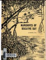 |
| Mangroves of Biscayne Bay |
|
| Publication Date: | |
1974
|
| Creator: | |
Teas, Howard J. (Howard Jones) 1920-
Metropolitan Dade County (Fla.). Board of County Commissioners ( contributor )
|
| Publisher.Display: | |
Dade County Department of Public Works ( Miami, Florida )
|
| Format: | |
107 pages illustrations (1 folded) 28 cm
|
| Subjects.Display: | |
Mangrove forests -- Florida
Mangrove plants -- Florida
Mangrove swamps -- Florida -- Biscayne Bay
Salt marsh ecology -- Florida -- Biscayne Bay
|
| Source Institution: | |
Florida International University
|
| Donor: | |
W.T. Muir
|
|
| Mangroves of Biscayne Bay |
|
 |
| Map and Seal of Florida |
|
| Publication Date: | |
1908
|
| Publisher.Display: | |
Emanuel Co.
|
| Subjects.Display: | |
Florida
Florida-Maps
|
| Source Institution: | |
Florida International University
|
|
| Map and Seal of Florida |
|
|
 |
| Map made for the U.S. Coast and Geodetic Survey of Cape Sable : East Cape to Shark River, April 12, 1928 |
|
| Publication Date: | |
1928
|
| Creator: | |
U.S. Coast and Geodetic Survey.
Reading, O. S. ( contributor )
|
| Format: | |
1 map
|
| Subjects.Display: | |
Everglades (Fla.)--Maps.
Sable, Cape (Fla.)--Maps.
Shark River (Fla.)--Maps.
Whitewater Bay (Fla.)--Maps.
|
| Source Institution: | |
Florida International University
|
|
| Map made for the U.S. Coast and Geodetic Survey of Cape Sable : East Cape to Shark River, April 12, 1928 |
|
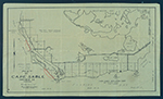 |
| Map of Cape Sable. |
|
| Creator: | |
Model Land Company.
|
| Format: | |
1 item.
|
| Subjects.Display: | |
Sable, Cape (Fla.)--Maps.
|
| Source Institution: | |
Florida International University
|
|
| Map of Cape Sable. |
|

