| |
|
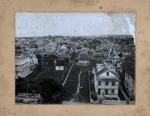 |
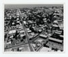
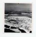
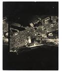
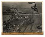
| 900 block of Whitehead Street |
|
| Publication Date: | |
1890
|
| Creator: | |
Monroe County Public Library System
May Hill Russell Library -- History Dept
Louise White Collection
|
| Format: | |
1 photograph : b&w ; 10 x 12 in.
|
| Subjects.Display: | |
Monroe -- 12087
Aerial photographs -- Monroe County (Fla.)
Buildings, structures, etc -- Aerial photographs -- Key West (Fla.)
Aerial photographs -- Key West (Fla.)
Houses -- Aerial photographs -- Florida -- Key West
|
| Source Institution: | |
Florida International University
|
|
| 900 block of Whitehead Street |
|
 |
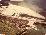
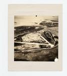
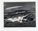
| Aerial of Casa Marina Court |
|
| Publication Date: | |
1945
|
| Creator: | |
Monroe County Public Library System
May Hill Russell Library -- History Dept
Ida Woodward Barron Collection
|
| Format: | |
1 photograph : b&w ; 7 x 7 in.
|
| Subjects.Display: | |
Monroe -- 12087
Aerial photographs -- Monroe County (Fla.)
Buildings, structures, etc -- Aerial photographs -- Key West (Fla.)
Aerial photographs -- Key West (Fla.)
Shorelines -- Aerial Photographs -- Key West (Fla.)
Beaches -- Aerial Photographs -- Florida -- Key West
|
| Source Institution: | |
Florida International University
|
|
| Aerial of Casa Marina Court |
|
|
 |
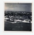
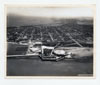
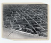
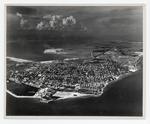
| An aerial photo of Key West from North Flagler across Fleming Key |
|
| Publication Date: | |
1942
|
| Creator: | |
Monroe County Public Library System
May Hill Russell Library -- History Dept
Ida Woodward Barron Collection
|
| Format: | |
1 photograph : b&w ; 8 x 10 in.
|
| Subjects.Display: | |
Monroe -- 12087
Aerial photographs -- Monroe County (Fla.)
Buildings, structures, etc -- Aerial photographs -- Key West (Fla.)
Aerial photographs -- Key West (Fla.)
Streets -- Aerial photographs -- Florida -- Key West
Bays -- Aerial photographs -- Florida -- Key West
Aerial photographs -- Naval station Key West (Fla.)
|
| Source Institution: | |
Florida International University
|
|
| An aerial photo of Key West from North Flagler across Fleming Key |
|
 |
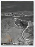
| An aerial photo of the Naval Hosptial site, golf course, and Highway One |
|
| Publication Date: | |
1941
|
| Creator: | |
Monroe County Public Library System
May Hill Russell Library -- History Dept
United States -- Navy
|
| Format: | |
1 photograph : b&w ; 8 x 10 in.
|
| Subjects.Display: | |
Monroe -- 12087
Aerial photographs -- Monroe County (Fla.)
Aerial photographs -- Key West (Fla.)
Roads -- Aerial photographs -- Florida -- Key West
Hospitals, Military -- Aerial photographs -- Florida -- Key West
Golf courses -- Aerial photographs -- Florida -- Key West
|
| Source Institution: | |
Florida International University
|
|
| An aerial photo of the Naval Hosptial site, golf course, and Highway One |
|
|
 |
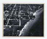
| Aerial view looking south on Duval Street |
|
| Publication Date: | |
1970
|
| Creator: | |
Monroe County Public Library System
May Hill Russell Library -- History Dept
United States -- Navy
|
| Format: | |
1 photograph : b&w ; 8 x 10 in.
|
| Subjects.Display: | |
Monroe -- 12087
Aerial photographs -- Monroe County (Fla.)
Buildings, structures, etc -- Aerial photographs -- Key West (Fla.)
Aerial photographs -- Key West (Fla.)
|
| Source Institution: | |
Florida International University
|
|
| Aerial view looking south on Duval Street |
|
 |
| Aerial view of Army tower |
|
| Publication Date: | |
1945
|
| Creator: | |
Monroe County Public Library System
May Hill Russell Library -- History Dept
Ida Woodward Barron Collection
|
| Format: | |
1 photograph : b&w ; 7 x 7 in.
|
| Subjects.Display: | |
Monroe -- 12087
Aerial photographs -- Monroe County (Fla.)
Aerial photographs -- Key West (Fla.)
Shorelines -- Aerial Photographs -- Key West (Fla.)
Water towers -- Aerial photographs -- Florida -- Key West
|
| Source Institution: | |
Florida International University
|
|
| Aerial view of Army tower |
|
|
 |
| An aerial view of Boca Chica |
|
| Publication Date: | |
1970
|
| Creator: | |
Monroe County Public Library System
May Hill Russell Library -- History Dept
Ida Woodward Barron Collection
|
| Format: | |
1 photograph : color ; 11 x 13 in.
|
| Subjects.Display: | |
Monroe -- 12087
Aerial photographs -- Monroe County (Fla.)
Airplanes -- Aerial photographs -- Florida -- Monroe County
|
| Source Institution: | |
Florida International University
|
|
| An aerial view of Boca Chica |
|
 |
| Aerial view of Fort Taylor looking northeast across Key West |
|
| Publication Date: | |
1936
|
| Creator: | |
Monroe County Public Library System
Aero-Graphic Corp
Thompson Family Collection
May Hill Russell Library -- History Dept
|
| Format: | |
1 photograph : b&w ; 8 x 10 in.
|
| Subjects.Display: | |
Monroe -- 12087
Aerial photographs -- Monroe County (Fla.)
Buildings, structures, etc -- Aerial photographs -- Key West (Fla.)
Aerial photographs -- Key West (Fla.)
Aerial photographs -- Fort Zachary Taylor (Key West, Fla.)
|
| Source Institution: | |
Florida International University
|
|
| Aerial view of Fort Taylor looking northeast across Key West |
|
|
 |
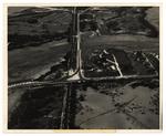
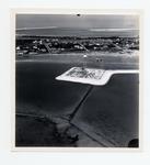
| Aerial view of Government Road and salt ponds taken December 19th, 1945 |
|
| Publication Date: | |
1945
|
| Creator: | |
Monroe County Public Library System
May Hill Russell Library -- History Dept
Ida Woodward Barron Collection
|
| Format: | |
1 photograph : b&w ; 7 x 7 in.
|
| Subjects.Display: | |
Photographs -- Key West (Fla.)
Monroe -- 12087
Aerial photographs -- Monroe County (Fla.)
Airports -- Aerial photographs -- Florida -- Key West
Bunkers (Fortification) -- Aerial Photographs -- Florida -- Key West
Roads -- Aerial photographs -- Florida -- Key West
Bridges -- Aerial photographs -- Florida -- Key West
Railroad bridges -- Aerial photographs -- Key West (Fla.)
|
| Source Institution: | |
Florida International University
|
|
| Aerial view of Government Road and salt ponds taken December 19th, 1945 |
|
 |
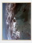
| Aerial view of Holiday Isle Resort |
|
| Subjects.Display: | |
Islamorada (Fla.)
aerial photographs
lcsh
lcnaf
|
| Source Institution: | |
Florida International University
|
|
| Aerial view of Holiday Isle Resort |
|
|
 |
| Aerial view of Hotel Casa Marina looking northeast to Garrison Bight |
|
| Publication Date: | |
1930
|
| Creator: | |
Monroe County Public Library System
May Hill Russell Library -- History Dept
Warren Family Collection
|
| Format: | |
1 photograph : b&w ; 8 x 10 in.
|
| Subjects.Display: | |
Monroe -- 12087
Aerial photographs -- Monroe County (Fla.)
Buildings, structures, etc -- Aerial photographs -- Key West (Fla.)
Aerial photographs -- Key West (Fla.)
Hotels -- Aerial photographs -- Florida -- Key West
Streets -- Aerial photographs -- Florida -- Key West
|
| Source Institution: | |
Florida International University
|
|
| Aerial view of Hotel Casa Marina looking northeast to Garrison Bight |
|
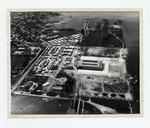 |
| An aerial view of Key West Bight & the Navy's Trumbo Point |
|
| Publication Date: | |
1941
|
| Creator: | |
Monroe County Public Library System
May Hill Russell Library -- History Dept
Key West Art & Historical Society
|
| Format: | |
1 photograph : b&w ; 8 x 10 in.
|
| Subjects.Display: | |
Monroe -- 12087
Aerial photographs -- Monroe County (Fla.)
Aerial photographs -- Key West (Fla.)
Bays -- Aerial photographs -- Florida -- Key West
Aerial photographs -- Naval station Key West (Fla.)
|
| Source Institution: | |
Florida International University
|
|
| An aerial view of Key West Bight & the Navy's Trumbo Point |
|
|
 |
| An aerial view of Key West from White Street to the Airport |
|
| Publication Date: | |
1960/1969
|
| Creator: | |
Monroe County Public Library System
May Hill Russell Library -- History Dept
|
| Format: | |
1 photograph : b&w ; 8 x 10 in.
|
| Subjects.Display: | |
Monroe -- 12087
Aerial photographs -- Monroe County (Fla.)
Aerial photographs -- Key West (Fla.)
Airports -- Aerial photographs -- Florida -- Key West
Roads -- Aerial photographs -- Florida -- Key West
|
| Source Institution: | |
Florida International University
|
| Donor: | |
Westray, Bill
|
|
| An aerial view of Key West from White Street to the Airport |
|
 |
| An aerial view of Key West looking northeast past Sigbee Park |
|
| Publication Date: | |
1950
|
| Creator: | |
Monroe County Public Library System
May Hill Russell Library -- History Dept
|
| Format: | |
1 photograph : b&w ; 8 x 10 in.
|
| Subjects.Display: | |
Monroe -- 12087
Aerial photographs -- Monroe County (Fla.)
Buildings, structures, etc -- Aerial photographs -- Key West (Fla.)
Aerial photographs -- Key West (Fla.)
Aerial photographs -- Fort Zachary Taylor (Key West, Fla.)
|
| Source Institution: | |
Florida International University
|
| Donor: | |
Simmons, John, 1942-1987, 1942-1987, 1942-1987, 1942-1987, 1942-1987
|
|
| An aerial view of Key West looking northeast past Sigbee Park |
|
|
 |
| Aerial view of southernmost point in Key West |
|
| Publication Date: | |
1941
|
| Creator: | |
Monroe County Public Library System
May Hill Russell Library -- History Dept
Ida Woodward Barron Collection
|
| Format: | |
1 photograph : b&w ; 8 x 10 in.
|
| Subjects.Display: | |
Monroe -- 12087
Aerial photographs -- Monroe County (Fla.)
Aerial photographs -- Key West (Fla.)
Aerial photographs -- Naval station Key West (Fla.)
Shorelines -- Photographs -- Key West (Fla.)
|
| Source Institution: | |
Florida International University
|
|
| Aerial view of southernmost point in Key West |
|
 |
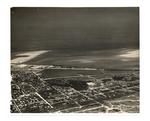
| Aerial view of the airport at Key West's eastern end |
|
| Publication Date: | |
1942
|
| Creator: | |
Monroe County Public Library System
May Hill Russell Library -- History Dept
Ida Woodward Barron Collection
|
| Format: | |
1 photograph : b&w ; 8 x 10 in.
|
| Subjects.Display: | |
Aerial photographs -- Monroe County (Fla.)
Buildings, structures, etc -- Aerial photographs -- Key West (Fla.)
Aerial photographs -- Key West (Fla.)
Airports -- Aerial photographs -- Florida -- Key West
Runways (Aeronautics) -- Aerial photographs -- Florida -- Key West
|
| Source Institution: | |
Florida International University
|
|
| Aerial view of the airport at Key West's eastern end |
|
|
 |
| An aerial view of the Naval Hosptial site, Casa Roma, North Roosevelt, and Highway One |
|
| Publication Date: | |
1941
|
| Creator: | |
Monroe County Public Library System
May Hill Russell Library -- History Dept
United States -- Navy
|
| Format: | |
1 photograph : b&w ; 8 x 10 in.
|
| Subjects.Display: | |
Monroe -- 12087
Aerial photographs -- Monroe County (Fla.)
Aerial photographs -- Key West (Fla.)
Hotels -- Aerial photographs -- Florida -- Key West
Roads -- Aerial photographs -- Florida -- Key West
Hospitals, Military -- Aerial photographs -- Florida -- Key West
|
| Source Institution: | |
Florida International University
|
|
| An aerial view of the Naval Hosptial site, Casa Roma, North Roosevelt, and Highway One |
|
 |
| Airport and eastern end of Key West looking north to Sigsbee |
|
| Publication Date: | |
1943
|
| Creator: | |
Monroe County Public Library System
May Hill Russell Library -- History Dept
Ida Woodward Barron Collection
|
| Format: | |
1 photograph : b&w ; 8 x 10 in.
|
| Subjects.Display: | |
Monroe -- 12087
Aerial photographs -- Monroe County (Fla.)
Buildings, structures, etc -- Aerial photographs -- Key West (Fla.)
Aerial photographs -- Key West (Fla.)
Airports -- Aerial photographs -- Florida -- Key West
Parks -- Aerial photographs -- Florida -- Key West
|
| Source Institution: | |
Florida International University
|
|
| Airport and eastern end of Key West looking north to Sigsbee |
|
|
 |
| Atlantic & Bertha Avenues from overhead |
|
| Publication Date: | |
1950
|
| Creator: | |
Monroe County Public Library System
May Hill Russell Library -- History Dept
|
| Format: | |
1 photograph : b&w ; 8 x 10 in.
|
| Subjects.Display: | |
Monroe -- 12087
Aerial photographs -- Monroe County (Fla.)
Streets -- Aerial photographs -- Florida
Aerial photographs -- Key West
|
| Source Institution: | |
Florida International University
|
| Donor: | |
Westray, Bill
|
|
| Atlantic & Bertha Avenues from overhead |
|
 |
| Bush Key with Fort Jefferson in the background |
|
| Publication Date: | |
1940/1949
|
| Creator: | |
Monroe County Public Library System
May Hill Russell Library -- History Dept
Ida Woodward Barron Collection
|
| Format: | |
1 photograph : b&w ; 8 x 10 in.
|
| Subjects.Display: | |
Monroe -- 12087
Aerial photographs -- Monroe County (Fla.)
Fortification -- Aerial photographs -- Florida
Aerial photographs -- Fort Jefferson (Fla.)
Aerial photographs -- Dry Tortugas (Fla.)
|
| Source Institution: | |
Florida International University
|
|
| Bush Key with Fort Jefferson in the background |
|

