|
|
| |
|
 |
| Miami Beach Chamber of Commerce Visitor Guide |
|
| Publication Date: | |
1996
|
| Creator: | |
Francis, Ron ( Photographer )
|
| Publisher.Display: | |
City of Miami Beach Chamber of Commerce, ( Miami Beach, Fla. : )
Greater Miami Convention and Vistors Bureau, ( Miami, Fla. : )
|
| Format: | |
1 viewbook XXp: xx
|
| Subjects.Display: | |
Miami Beach (Fla.)
Miami Beach (Fla.)--Pictorial works.
Miami Beach (Fla.)--Buildings, structures, etc.--Pictorial works.
Monuments & memorials--1990-2000.
Advertising--United States--Florida--Miami Beach.
Tourism--1990-2000.
Hotels--United States--Florida--Miami Beach--1990-2000.
Restaurants--United States--Florida--Miami Beach--1990-2000.
Automobiles--United States--Florida--Miami--1990-2000.
Sports & recreation facilities--1990-2000.
|
| Source Institution: | |
City of Miami Beach
|
|
| Miami Beach Chamber of Commerce Visitor Guide |
|
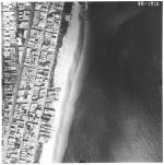 |
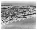
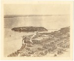
| Aerial survey photographs of Miami Beach between Lummus Park to Government Cut. |
|
| Publisher.Display: | |
Rader & Associates, ( Miami, Fla. : )
|
| Format: | |
5 photographs : ill. ; 23 x 23 cm.
|
| Measurements: | |
23 x 23
|
| Subjects.Display: | |
Miami Beach (Fla.)--Buildings, structures, etc.--Pictorial works.
Miami Beach (Fla.)--Aerial views.
Miami Beach (Fla.)--Aerial photographs.
Collins Avenue (Miami Beach, Fla.)--1950-1960.
Houses--1950-1960.
Parks--1950-1960.
Washington Avenue (Miami Beach, Fla.)--1950-1960.
Lincoln Road (Miami Beach, Fla.)--1950-1960.
Ocean Drive (Miami Beach, Fla.)--1950-1960.
Streets--1950-1970.
|
| Source Institution: | |
City of Miami Beach
|
| Donor: | |
Ares, Aristotle.
|
|
| Aerial survey photographs of Miami Beach between Lummus Park to Government Cut. |
|
|
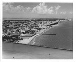 |
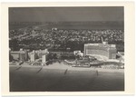
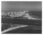
| Aerial view looking north from Government Cut showing Greyhound Racetrack in South Shore, 1964 |
|
| Publication Date: | |
1964
|
| Creator: | |
Hansen, Chris ( Photographer )
|
| Publisher.Display: | |
City of Miami Beach News Bureau, ( Miami Beach, Fla. : )
|
| Format: | |
1 photograph : ill. ; 21 x 26 cm.
|
| Subjects.Display: | |
Miami Beach (Fla.)--Pictorial works.
Miami Beach (Fla.)--Buildings, structures, etc.--Pictorial works.
Miami Beach (Fla.)--Aerial photographs.
Beaches--United States--Florida--Miami Beach--1960-1970.
Lummus Park (Miami Beach, Fla.)
Channels--1960-1970.
Racetracks--1960-1970.
Jetties--1960-1970
Government Cut (Miami Beach (Fla.)
|
| Source Institution: | |
City of Miami Beach
|
|
| Aerial view looking north from Government Cut showing Greyhound Racetrack in South Shore, 1964 |
|
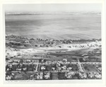 |
| Aerial view of La Gorce golf course |
|
| Publication Date: | |
1930
|
| Creator: | |
Miami Beach Visitor & Convention Authority
|
| Publisher.Display: | |
Miami Beach Visitor and Convention Authority, ( Miami Beach, Fla. : )
|
| Format: | |
1 photograph: ill, ; 20 x 24 cm.
|
| Measurements: | |
20 x 24
|
| Subjects.Display: | |
Miami Beach (Fla.)--Buildings, structures, etc.--Pictorial works.
Miami Beach (Fla.)--Aerial photographs.
Houses--1920-1930.
Streets--1930-1940.
Golf courses--1930-1940.
Lakes and ponds--1920-1930.
|
| Source Institution: | |
City of Miami Beach
|
|
| Aerial view of La Gorce golf course |
|
|
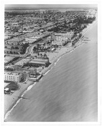 |
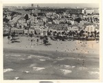
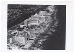
| Aerial view of Miami Beach, looking north from Seventy-first Street |
|
| Publication Date: | |
1964
|
| Creator: | |
Hansen, Chris ( Photographer )
|
| Publisher.Display: | |
The City of Miami Beach News Bureau, ( Miami Beach, Fla. : )
|
| Format: | |
1 photograph : ill. ; 26 x 21 cm.
|
| Measurements: | |
26 x 21
|
| Subjects.Display: | |
Miami Beach (Fla.)--Buildings, structures, etc.--Pictorial works.
Miami Beach (Fla.)--Aerial photographs.
Beaches--United States--Florida--Miami Beach--1960-1970.
Parks--United States--Florida--Miami Beach--1960-1970.
Lummus Park (Miami Beach, Fla. )
|
| Source Institution: | |
City of Miami Beach
|
|
| Aerial view of Miami Beach, looking north from Seventy-first Street |
|
 |
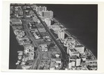
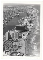
| Aerial view of Miami Beach looking west, 1964 |
|
| Publication Date: | |
1964
|
| Creator: | |
Hansen, Chris ( Photographer )
|
| Publisher.Display: | |
City of Miami Beach News Bureau, ( Miami Beach, Fla. : )
|
| Format: | |
1 photograph : ill. ; 20 x 25 cm.
|
| Measurements: | |
20 x 25
|
| Subjects.Display: | |
Miami Beach (Fla.)--Pictorial works.
Miami Beach (Fla.)--Buildings, structures, etc.--Pictorial works.
Miami Beach (Fla.)--Aerial views.
Beaches--United States--Florida--Miami Beach--1960-1970.
Ocean Drive (Miami Beach, Fla.)--1960-1970.
Aerial photographs.
|
| Source Institution: | |
City of Miami Beach
|
|
| Aerial view of Miami Beach looking west, 1964 |
|
|
 |
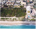
| Aerial view of North Miami Beach |
|
| Publication Date: | |
1940
|
| Publisher.Display: | |
City of Miami Beach News Bureau
|
| Format: | |
Series includes 32 photographs : ill. ; 18 x 13 cm.
|
| Subjects.Display: | |
Swimming pools
Miami Beach (Fla.)--Buildings, structures, etc.--Pictorial works.
|
| Source Institution: | |
City of Miami Beach
|
|
Aerial view of North Miami Beach
( 31 volumes ) |
|
 |
| Aerial view of Ocean Drive between Fifth and Seventh Streets in 1960s |
|
| Publication Date: | |
1960
|
| Format: | |
1 photograph : ill. ; 19 x 24 cm.
|
| Measurements: | |
19 x 24
|
| Subjects.Display: | |
Miami Beach (Fla.)--Buildings, structures, etc.--Pictorial works.
Miami Beach (Fla.)--Aerial views.
Bathing beaches--United States--Florida--Miami Beach--History--20th century--Pictorial works.
Beaches--United States--Florida--Miami Beach--1960-1970.
Palms--United States--Florida--Miami Beach--1960-1970.
Causeways--1960-1970.
Ocean waves--United States--Florida--Miami Beach--Pictorial works.
|
| Source Institution: | |
City of Miami Beach
|
|
| Aerial view of Ocean Drive between Fifth and Seventh Streets in 1960s |
|
|
 |
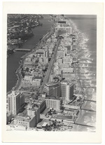
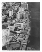
| Aerial view of oceanfront hotels looking north |
|
| Publication Date: | |
1972/1974
|
| Creator: | |
Chris Hansen
Miami Beach Tourist Development Auth. Publicity Dept
|
| Publisher.Display: | |
The City of Miami Beach Tourist Development Authority, Publicity Department
|
| Format: | |
8 x 10 cm
|
| Subjects.Display: | |
Miami Beach (Fla.)--Pictorial works.
Miami Beach (Fla.)--Buildings, structures, etc.--Pictorial works.
Miami Beach (Fla.)--Aerial views.
Miami Beach (Fla.)--Aerial photographs.
Beaches--1970-1980.
Hotels--1970-1980.
|
| Source Institution: | |
City of Miami Beach
|
| Donor: | |
Miami Beach Public Works Department
|
|
Aerial view of oceanfront hotels looking north
( 37 volumes ) |
|
 |
| Aerial view of the Flamingo Hotel and Belle Isle |
|
| Publication Date: | |
1922
|
| Format: | |
1 photograph : ill. ; 10 x 12 cm.
|
| Measurements: | |
10 x 12
|
| Subjects.Display: | |
Flamingo Hotel (Miami Beach, Fla.)
Miami Beach (Fla.)--Pictorial works.
Miami Beach (Fla.)--Buildings, structures, etc.--Pictorial works.
Miami Beach (Fla.)--Aerial photographs.
Hotels--1920-1930.
Islands--United States--Florida--Miami Beach--1920-1930.
|
| Source Institution: | |
City of Miami Beach
|
|
| Aerial view of the Flamingo Hotel and Belle Isle |
|
|
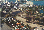 |
| Aerial view of the southest part of the Miami Beach Golf Club. |
|
| Publication Date: | |
2002
|
| Publisher.Display: | |
City of Miami Beach
|
| Format: | |
Series includes 12 photographs : col. ill. ; 10 x 15 cm.
|
| Subjects.Display: | |
Miami Beach (Fla.)--Pictorial works.
Miami Beach (Fla.)--Aerial views.
Miami (Fla.)--Buildings, structures, etc.--Pictorial works.
Government Cut (Miami Beach, Fla.)--Pictorial works.
|
| Source Institution: | |
City of Miami Beach
|
|
Aerial view of the southest part of the Miami Beach Golf Club.
( 12 volumes ) |
|
 |
| Aerial views of Belle Isle |
|
| Publication Date: | |
1965
|
| Format: | |
6 photographs : ill. ; 13 x 18 cm.
|
| Measurements: | |
13 x 18
|
| Subjects.Display: | |
Miami Beach (Fla.)--Buildings, structures, etc.--Pictorial works.
Miami Beach (Fla.)--Aerial photographs.
Islands--1950-1970.
Causeways--1950-1970.
|
| Source Institution: | |
City of Miami Beach
|
|
| Aerial views of Belle Isle |
|
|
 |
| Aerial views of Miami Beach |
|
| Publication Date: | |
1961
|
| Creator: | |
Wengrow, Lloyd
|
| Format: | |
1 pamphlet 36p : ill.
|
| Subjects.Display: | |
Library catalogs
|
| Source Institution: | |
City of Miami Beach
|
|
Aerial views of Miami Beach
( 2 volumes ) |
|
 |
| Aerial views of Miami Beach, 1950s |
|
| Publication Date: | |
1953
|
| Creator: | |
Hansen, Chris ( Photographer )
Finley, Ed ( Photographer )
|
| Publisher.Display: | |
The City of Miami Beach News Bureau ( Miami Beach, Fla. : )
|
| Format: | |
S
|
| Subjects.Display: | |
Miami Beach (Fla.)
Miami Beach (Fla.)--Buildings, structures, etc.--Pictorial works.
Miami Beach (Fla.)--Aerial views.
Waterways--1950-1960.
Hotels--1950-1960.
Streets--1950-1960.
Parks--United States--Florida--Miami Beach--1950-1960.
Parking lots--United States--Florida--Miami Beach.
Sailboats--1950-1960.
|
| Source Institution: | |
City of Miami Beach
|
|
| Aerial views of Miami Beach, 1950s |
|
|
 |
| Aerial views of Miami Beach and surrounding islands, 1960-1970 |
|
| Publication Date: | |
1960/1970
|
| Creator: | |
Hansen, Chris. ( Photographer )
Hamilton, George. ( Photographer )
|
| Format: | |
34 photographs : col. ill. ; 17 x 13 cm.
|
| Measurements: | |
17 x 13
|
| Subjects.Display: | |
Miami Beach (Fla.)
Miami Beach (Fla.)--Buildings, structures, etc.--Pictorial works.
Miami Beach (Fla.)--Aerial views.
Miami Beach (Fla.)--Aerial photographs.
Fontainebleau (Miami Beach, Fla.)
Government Cut--Pictorial works.
South Pointe Park (Miami Beach, Fla.).
Streets--United States--Florida--Miami Beach--1960-1970.
Apartment buildings--United States--Florida--Miami Beach--1960-1970.
Islands--United States--Florida--Miami Beach--1960-1970.
Beaches--United States--Florida--Miami Beach--1960-1970.
Swimming pools--United States--Florida--Miami Beach--1960-1970.
Parks--United States--Florida--Miami Beach--1960-1970.
Hotels--United States--Florida--Miami Beach--1960-1970.
Palms--United States--Florida--Miami Beach--1960-1970.
Causeways--1960-1970.
Lummus Park (Miami Beach, Fla.).
Ocean Drive (Miami Beach, Fla.)--1960-1970.
Boats--United States--Florida--Miami Beach--1960-1970.
Collins Avenue (Miami Beach, Fla.)--1960-1970.
|
| Source Institution: | |
City of Miami Beach
|
|
| Aerial views of Miami Beach and surrounding islands, 1960-1970 |
|
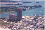 |
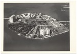
| Aerial views of Miami Beach looking north and south and Fisher Island |
|
| Publication Date: | |
2000
|
| Format: | |
6 photographs: col. ill. ; 11 x 16 cm.
|
| Measurements: | |
11 x 16
|
| Subjects.Display: | |
Miami Beach (Fla.)--Buildings, structures, etc.--Pictorial works.
Miami Beach (Fla.)--Aerial views.
Hotels--2000-2010.
Convention facilities--United States--Florida--Miami Beach--Pictorial works.
Islands--2000-2010.
Apartment buildings--2000-2010.
Construction--2000-2010.
Piers & wharves--2000-2010.
|
| Source Institution: | |
City of Miami Beach
|
|
| Aerial views of Miami Beach looking north and south and Fisher Island |
|
|
 |
| Aerial Views of Miami Beach,1960-1980 |
|
| Publication Date: | |
1980
|
| Creator: | |
Hansen, Chris ( Photographer )
|
| Format: | |
32 photographs : col. ill. ; 18 x 13 cm.
|
| Measurements: | |
18 x 13
|
| Subjects.Display: | |
Miami Beach (Fla.)
Indian Creek (Miami Beach, Fla.)
Miami Beach (Fla.)--Buildings, structures, etc.--Pictorial works.
Miami Beach (Fla.)--Aerial views.
Miami Beach (Fla.)--Aerial photographs.
Miami (Fla.)--Pictorial works.
Construction--1960-1980.
Clearing of land--United States--Florida--Miami Beach--1960-1980.
Hotels--United States--Florida--Miami Beach--1960-1980.
Golf courses--1960-1980.
Streets--United States--Florida--Miami Beach--1960-1980.
Street lights--1960-1980.
Causeways--1960-1980.
Bridges--1960-1980.
Lincoln Road (Miami Beach, Fla.)--1960-1980.
Dade Boulevard (Miami Beach, Fla.)--1960-1980.
Collins Avenue (Miami Beach, Fla.)--1960-1980.
Beaches--United States--Florida--Miami Beach--1960-1980.
Waterways--1960-1980.
Canals--1960-1980.
|
| Source Institution: | |
City of Miami Beach
|
|
| Aerial Views of Miami Beach,1960-1980 |
|
 |
| Aerial views of oceanfront buildings and Miami Beach, late 1960s |
|
| Publication Date: | |
1969-07-09
|
| Creator: | |
Hansen, Chris ( Photographer )
|
| Publisher.Display: | |
The City of Miami Beach News Bureau, ( Miami Beach, Fla. : )
|
| Subjects.Display: | |
Miami Beach (Fla.)
Miami Beach (Fla.)--Buildings, structures, etc.--Pictorial works.
Beaches--Environmental aspects.
Hotels--1960-1970.
Monuments & memorials--1960-1970.
Islands--1960-1970.
Aerial views--Pictorial works.
|
| Source Institution: | |
City of Miami Beach
|
| Donor: | |
City of Miami Beach, Public Works Department
|
|
| Aerial views of oceanfront buildings and Miami Beach, late 1960s |
|
|
 |
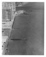
| Aerial views of oceanfront buildings showing parks and beach erosion between Fisher Island and Halouver Pass, 1969 |
|
| Publication Date: | |
1969-11-03
|
| Creator: | |
Hansen, Chris
|
| Publisher.Display: | |
The City of Miami Beach News Bureau, ( Miami Beach, Fla. : )
|
| Subjects.Display: | |
Miami Beach (Fla.)
Miami Beach (Fla.)--Buildings, structures, etc.--Pictorial works.
Miami Beach (Fla.)--Aerial views.
Beaches--Environmental aspects.
Beaches--United States--Florida--Miami Beach--1960-1970.
Hotels--1960-1970.
Parks--1960-1970.
Construction--1960-1970.
Gardens--1960-1970.
|
| Source Institution: | |
City of Miami Beach
|
|
| Aerial views of oceanfront buildings showing parks and beach erosion between Fisher Island and Halouver Pass, 1969 |
|
 |
| Aerial views of oceanfront hotels |
|
| Publication Date: | |
1980/1989
|
| Creator: | |
Hansen, Chris ( Photographer )
|
| Format: | |
20 photographs : col. ill. ; 13 x 18 cm.
|
| Measurements: | |
13 x 18
|
| Subjects.Display: | |
Miami Beach (Fla.)
Miami Beach (Fla.)--Pictorial works.
Miami Beach (Fla.)--Buildings, structures, etc.--Pictorial works.
Miami Beach (Fla.)--Aerial views.
Hotels--1950-1970.
Islands--1950-1970.
Waterways--1950-1970.
|
| Source Institution: | |
Miami Beach Digital Archive
|
|
| Aerial views of oceanfront hotels |
|
|

