| |
|
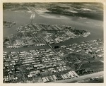 |
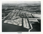
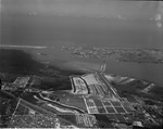
| Aerial view looking west at Surfside, Bal Harbour, Bay Harbor, and North Miami |
|
| Publication Date: | |
1952-04-12
|
| Creator: | |
McKay Aerial Photos
|
| Format: | |
1 b&w photograph ; 8 x 10 inches
|
| Subjects.Display: | |
North Miami (Fla.) -- Aerial views
|
| Source Institution: | |
Greater North Miami Historical Society
|
|
| Aerial view looking west at Surfside, Bal Harbour, Bay Harbor, and North Miami |
|
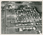 |
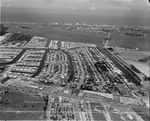
| Aerial view of 125th. Street to Florida East Coast railway in 1958 |
|
| Publication Date: | |
1958
|
| Format: | |
1 b&w photograph ; 8 x 10 inches
|
| Subjects.Display: | |
North Miami (Fla.) -- Aerial views
|
| Source Institution: | |
Greater North Miami Historical Society
|
|
| Aerial view of 125th. Street to Florida East Coast railway in 1958 |
|
|
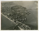 |
| Aerial view of Bal Harbour, Bay Harbor Islands and Indian Creek in Florida |
|
| Publication Date: | |
1957-03-14
|
| Creator: | |
Tierney and Killingswoth
|
| Format: | |
1 b&w Photograph; 8 x 10 inches
|
| Subjects.Display: | |
Bay Harbor Islands (Fla.) -- Aerial views
Bal Harbour (Fla.) -- Aerial views
Indian Creek Village (Fla.) -- Aerial views
|
| Source Institution: | |
Greater North Miami Historical Society
|
|
| Aerial view of Bal Harbour, Bay Harbor Islands and Indian Creek in Florida |
|
 |
| Aerial view of Bal Harbour, Florida |
|
| Publication Date: | |
1961-12-06
|
| Creator: | |
Tierney and Killingswoth
|
| Format: | |
1 b&w Photograph; 8 x 10 inches
|
| Subjects.Display: | |
Bal Harbour (Fla.) -- Aerial views
|
| Source Institution: | |
Greater North Miami Historical Society
|
|
| Aerial view of Bal Harbour, Florida |
|
|
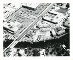 |
| Aerial view of Biscayne Shopping Plaza, NE 79 St. and Biscayne Blvd. |
|
| Publication Date: | |
1950-1959
|
| Format: | |
1 b&w photograph ; 8 x 10 inches
|
| Subjects.Display: | |
Roads -- Florida -- North Miami
Miami (Fla.) -- Aerial views
|
| Source Institution: | |
Greater North Miami Historical Society
|
|
| Aerial view of Biscayne Shopping Plaza, NE 79 St. and Biscayne Blvd. |
|
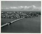 |
| Aerial view of Broad Causeway bridge looking east to Bay Harbor Islands in Florida |
|
| Publication Date: | |
1961-12-06
|
| Creator: | |
Tierney and Killingswoth
|
| Format: | |
1 b&w Photograph; 8 x 10 inches
|
| Subjects.Display: | |
Bay Harbor Islands (Fla.) -- Aerial views
|
| Source Institution: | |
Greater North Miami Historical Society
|
|
| Aerial view of Broad Causeway bridge looking east to Bay Harbor Islands in Florida |
|
|
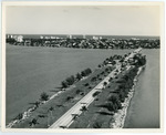 |
| Aerial view of Broad Causeway looking east to Bay Harbor Islands in Florida |
|
| Publication Date: | |
1961-12-06
|
| Creator: | |
Tierney and Killingswoth
|
| Format: | |
1 b&w Photograph; 8 x 10 inches
|
| Subjects.Display: | |
Bay Harbor Islands (Fla.) -- Aerial views
|
| Source Institution: | |
Greater North Miami Historical Society
|
|
| Aerial view of Broad Causeway looking east to Bay Harbor Islands in Florida |
|
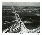 |
| Aerial view of Golden Glades Cloverleaf |
|
| Publication Date: | |
1950-1959
|
| Creator: | |
Ernie's Studio & Camera Center
|
| Format: | |
1 b&w photograph ; 8 x 10 inches
|
| Subjects.Display: | |
Roads -- Florida -- North Miami
Neighborhoods -- Florida -- North Miami
Golden Glades (Fla.) -- Aerial views
|
| Source Institution: | |
Greater North Miami Historical Society
|
|
| Aerial view of Golden Glades Cloverleaf |
|
|
 |
| Aerial view of Keystone Islands in North Miami |
|
| Publication Date: | |
1950-1959
|
| Creator: | |
Ernie's Studio & Camera Center
|
| Format: | |
1 b&w photograph ; 8 x 10 inches
|
| Subjects.Display: | |
Roads -- Florida -- North Miami
North Miami (Fla.) -- Aerial views
Neighborhoods -- Florida -- North Miami
Keystone Islands (North Miami, Fla.)
|
| Source Institution: | |
Greater North Miami Historical Society
|
|
| Aerial view of Keystone Islands in North Miami |
|
 |
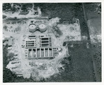
| Aerial view of Keystone Point |
|
| Publication Date: | |
1957-01-10
|
| Format: | |
1 b&w negative; 4x5 inches
|
| Subjects.Display: | |
North Miami (Fla.) -- Aerial views
Keystone Islands (North Miami, Fla.)
|
| Source Institution: | |
Greater North Miami Historical Society
|
|
| Aerial view of Keystone Point |
|
|
 |
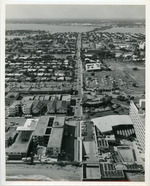
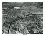
| Aerial view of N.E. 8 Avenue looking north |
|
| Publication Date: | |
1960s
|
| Format: | |
1 b&w photograph ; 8 x 10 inches
|
| Subjects.Display: | |
North Miami (Fla.) -- Aerial views
|
| Source Institution: | |
Greater North Miami Historical Society
|
|
| Aerial view of N.E. 8 Avenue looking north |
|
 |
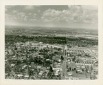
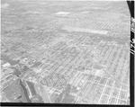
| Aerial view of North Miami |
|
| Publication Date: | |
1950-1959
|
| Creator: | |
Ernie's Studio & Camera Center
|
| Format: | |
1 b&w photograph ; 8 x 10 inches
|
| Subjects.Display: | |
Roads -- Florida -- North Miami
North Miami (Fla.) -- Aerial views
Neighborhoods -- Florida -- North Miami
|
| Source Institution: | |
Greater North Miami Historical Society
|
|
| Aerial view of North Miami |
|
|
 |
| Aerial view of North Miami Downtown |
|
| Publication Date: | |
1950-1959
|
| Format: | |
1 b&w photograph ; 8 x 10 inches
|
| Subjects.Display: | |
Roads -- Florida -- North Miami
North Miami (Fla.) -- Aerial views
Neighborhoods -- Florida -- North Miami
|
| Source Institution: | |
Greater North Miami Historical Society
|
|
| Aerial view of North Miami Downtown |
|
 |
| Aerial view of North Miami looking South West and West |
|
| Format: | |
1 b&w negative; 4x5 inches
|
| Subjects.Display: | |
North Miami (Fla.) -- Aerial views
|
| Source Institution: | |
Greater North Miami Historical Society
|
|
| Aerial view of North Miami looking South West and West |
|
|
 |
| Aerial view of North Miami looking South West and West |
|
| Format: | |
1 b&w negative; 4x5 inches
|
| Subjects.Display: | |
North Miami (Fla.) -- Aerial views
|
| Source Institution: | |
Greater North Miami Historical Society
|
|
| Aerial view of North Miami looking South West and West |
|
 |
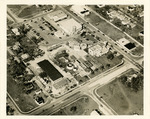
| Aerial view of the North Miami sewage disposal plant and surrounded area |
|
| Publication Date: | |
1956-09-14
|
| Creator: | |
North Miami Police
|
| Format: | |
1 b&w photograph ; 8 x 10 inches
|
| Subjects.Display: | |
North Miami (Fla.) -- Aerial views
Sewage disposal plants -- Florida -- North Miami
|
| Source Institution: | |
Greater North Miami Historical Society
|
|
| Aerial view of the North Miami sewage disposal plant and surrounded area |
|
|
 |
| Keystone Point-looking East |
|
| Publication Date: | |
1951-12-29
|
| Format: | |
1b&w negative; 4x5 inches
|
| Subjects.Display: | |
North Miami (Fla.) -- Aerial views
Keystone Islands (North Miami, Fla.)
|
| Source Institution: | |
Greater North Miami Historical Society
|
|
| Keystone Point-looking East |
|
|

