 |
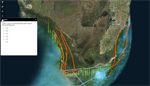
| Historical US Coast and Geodetic Survey (USCGS) Aerial Photos - South Florida |
|
| Publication Date: | |
2017
|
| Creator: | |
US Coast and Geodetic Survey (USCGS)
Wanless, Harold R. ( Curator )
Harlem, Peter W. ( Contributor )
|
| Publisher.Display: | |
Florida International University ( Miami, Fla. )
|
| Subjects.Display: | |
Florida
South Florida
coastal management
aerial photographs
|
| Source Institution: | |
Florida International University
|
|
| Historical US Coast and Geodetic Survey (USCGS) Aerial Photos - South Florida |
|
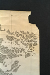 |
| Map made for the U.S. Coast and Geodetic Survey of Cape Sable : East Cape to Shark River, April 12, 1928 |
|
| Publication Date: | |
1928
|
| Creator: | |
U.S. Coast and Geodetic Survey.
Reading, O. S. ( contributor )
|
| Format: | |
1 map
|
| Subjects.Display: | |
Everglades (Fla.)--Maps.
Sable, Cape (Fla.)--Maps.
Shark River (Fla.)--Maps.
Whitewater Bay (Fla.)--Maps.
|
| Source Institution: | |
Florida International University
|
|
| Map made for the U.S. Coast and Geodetic Survey of Cape Sable : East Cape to Shark River, April 12, 1928 |
|

