|
|
| |
|
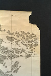 |
| Map made for the U.S. Coast and Geodetic Survey of Cape Sable : East Cape to Shark River, April 12, 1928 |
|
| Publication Date: | |
1928
|
| Creator: | |
U.S. Coast and Geodetic Survey.
Reading, O. S. ( contributor )
|
| Format: | |
1 map
|
| Subjects.Display: | |
Everglades (Fla.)--Maps.
Sable, Cape (Fla.)--Maps.
Shark River (Fla.)--Maps.
Whitewater Bay (Fla.)--Maps.
|
| Source Institution: | |
Florida International University
|
|
| Map made for the U.S. Coast and Geodetic Survey of Cape Sable : East Cape to Shark River, April 12, 1928 |
|
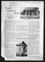 |
| 'Neath southern skies |
|
| Publication Date: | |
1919
|
| Creator: | |
Heilner, Van Campen, 1899-
Reclaiming the Everglades ( Contributor )
|
| Publisher.Display: | |
Field and Stream
|
| Format: | |
4 p. : ill. ;
|
| Subjects.Display: | |
Sable, Cape (Fla.)
Ten Thousand Islands (Fla.)
Florida Bay (Fla.)
Shark River (Fla.)
Description and travel -- Everglades (Fla.)
Alligators -- Florida -- Everglades
Fishing -- Florida -- Everglades
Hunting -- Florida -- Everglades
Tiger, Tommie
Bradley, Guy -- 1870-1905
|
| Source Institution: | |
Florida International University
|
|
| 'Neath southern skies |
|
|
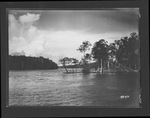 |
| Photographs depicting Shark River and environs, 1929. |
|
| Publication Date: | |
1929
|
| Creator: | |
Matlack, Claude Carson, 1878-1944.
|
| Format: | |
4 photos. : black and white; 18 x 13 cm.
|
| Subjects.Display: | |
Everglades (Fla.)
Everglades (Fla.)--Photographs.
Shark River (Fla.)
Hardwood hammocks
|
| Source Institution: | |
Florida International University
|
|
| Photographs depicting Shark River and environs, 1929. |
|
|
|

