|
|
| |
|
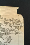 |
| Map made for the U.S. Coast and Geodetic Survey of Cape Sable : East Cape to Shark River, April 12, 1928 |
|
| Publication Date: | |
1928
|
| Creator: | |
U.S. Coast and Geodetic Survey.
Reading, O. S. ( contributor )
|
| Format: | |
1 map
|
| Subjects.Display: | |
Everglades (Fla.)--Maps.
Sable, Cape (Fla.)--Maps.
Shark River (Fla.)--Maps.
Whitewater Bay (Fla.)--Maps.
|
| Source Institution: | |
Florida International University
|
|
| Map made for the U.S. Coast and Geodetic Survey of Cape Sable : East Cape to Shark River, April 12, 1928 |
|
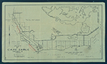 |
| Map of Cape Sable. |
|
| Creator: | |
Model Land Company.
|
| Format: | |
1 item.
|
| Subjects.Display: | |
Sable, Cape (Fla.)--Maps.
|
| Source Institution: | |
Florida International University
|
|
| Map of Cape Sable. |
|
|
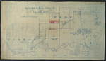 |
| Map showing special road and bridges, Cape Sable District, Monroe County, 1920 |
|
| Publication Date: | |
1920
|
| Creator: | |
Livingston, A. R.
|
| Format: | |
1 map.
|
| Subjects.Display: | |
Monroe--12087--ceeus
Ingraham Highway (Fla.)
Everglades (Fla.)--Maps.
Jennings Tract (Fla.)
Monroe County (Fla.)--Maps.
Sable, Cape (Fla.)--Maps.
|
| Source Institution: | |
Florida International University
|
|
| Map showing special road and bridges, Cape Sable District, Monroe County, 1920 |
|
 |
| Records relating to Ingraham Highway and Royal Palm Hammock (Royal Palm State Park) |
|
| Publication Date: | |
1920
|
| Creator: | |
Model Land Company
Reclaiming the Everglades ( Contributor )
Ingraham, James Edmundson, 1850-1924 ( contributor )
Harrison, Sidney ( contributor )
Pepper, Frank J., b. 1880 ( contributor )
Morse, Frederick S., 1859-1920 ( contributor )
Dooley, A. A. ( contributor )
Dewhurst, William W ( William Whitwell ), b. 1850 ( contributor )
Parker, Dorothy D. ( contributor )
|
| Format: | |
61 items (68 p.), 1 map. : ;
|
| Subjects.Display: | |
Sable, Cape (Fla.)
Maps -- Everglades (Fla.)
Ingraham Highway (Fla.)
Royal Palm Hammock (Fla.)
Royal Palm State Park (Fla.)
Flamingo (Fla.)
Long Pine Key (Fla.)
Mangrove -- Maps
Marl -- Maps
Camp Dewhurst (Fla.)
Camp Jennings (Fla.)
Camp Omega (Fla.)
Jennings, William Sherman -- 1863-1920
Cape Sable Development Company
Dewhurst, William W. -- William Whitwell -- b. 1850
McCrary, J. B.
Mosier, Charles R.
McCrary Engineering Corporation
Paradise Land Company
Paradise Prairie Land Co.
|
| Source Institution: | |
Florida International University
|
|
| Records relating to Ingraham Highway and Royal Palm Hammock (Royal Palm State Park) |
|
|
 |
| Records relating to land in the Cape Sable region |
|
| Publication Date: | |
1913
|
| Creator: | |
Model Land Company
Reclaiming the Everglades ( Contributor )
|
| Format: | |
3 items. : ;
|
| Subjects.Display: | |
Sable, Cape (Fla.)
Maps -- Everglades (Fla.)
Maps -- Monroe County (Fla.)
Maps -- Sable, Cape (Fla.)
Jennings, William Sherman -- 1863-1920
Dewhurst, William W. -- (William Whitwell) -- b. 1850
|
| Source Institution: | |
Florida International University
|
|
| Records relating to land in the Cape Sable region |
|
|
|

