|
|
| |
|
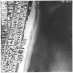
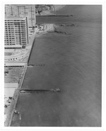
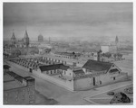
![[Aerial views of Miami Beach, showing sections of man-made island areas, 1941-1959].<br />( 12 volumes )](http://dpanther.fiu.edu/sobek/content/MB/00/00/13/71/00001/1371_10_000thm.jpg) |
| [Aerial views of Miami Beach, showing sections of man-made island areas, 1941-1959]. |
|
| Publication Date: | |
1941
|
| Publisher.Display: | |
Aerial Survey Corp., ( Lansing, Mich. : )
|
| Subjects.Display: | |
Miami Beach (Fla.)
Miami Beach (Fla.)--Buildings, structures, etc.--Pictorial works.
Miami Beach (Fla.)--Aerial views.
Islands--1940-1950.
Causeways--1940-1950.
|
| Source Institution: | |
City of Miami Beach
|
|
[Aerial views of Miami Beach, showing sections of man-made island areas, 1941-1959].
( 12 volumes ) |
|
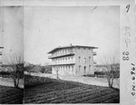
![[St. Augustine Alligator Hunt Club in front of Rosario Redoubt, 1870]](http://dpanther.fiu.edu/sobek/content/US/AC/H0/00/34/00001/USACH00034_00001_00001thm.jpg) |
| [St. Augustine Alligator Hunt Club in front of Rosario Redoubt, 1870] |
|
| Publisher.Display: | |
St. Augustine Restoration, Inc.
|
| Subjects.Display: | |
Saint Augustine (Fla.)
48 King Street (Saint Augustine, Fla.)
Government House (Saint Augustine, Fla.)
|
| Source Institution: | |
University of Florida
|
|
| [St. Augustine Alligator Hunt Club in front of Rosario Redoubt, 1870] |
|
|
 |
| Act of legislature of 1913 establishing city government for the city of Miami, Florida |
|
| Publication Date: | |
1913
|
| Creator: | |
Miami (Fla.). City Council
|
| Publisher.Display: | |
Miami (Fla.)
|
| Format: | |
62 p. : ; 23 cm.
|
| Subjects.Display: | |
Miami-Dade County (Fla.)
Charters -- Miami (Fla.) ( lcsh )
Economics and Society: Post-Civil War Florida, 1865-1913 -- The New Century and a Growing State, 1899-1913 ( fhp )
|
| Source Institution: | |
Florida International University
|
|
| Act of legislature of 1913 establishing city government for the city of Miami, Florida |
|
 |
| Aerial survey photographs of Miami Beach between Lummus Park to Government Cut. |
|
| Publisher.Display: | |
Rader & Associates, ( Miami, Fla. : )
|
| Format: | |
5 photographs : ill. ; 23 x 23 cm.
|
| Measurements: | |
23 x 23
|
| Subjects.Display: | |
Miami Beach (Fla.)--Buildings, structures, etc.--Pictorial works.
Miami Beach (Fla.)--Aerial views.
Miami Beach (Fla.)--Aerial photographs.
Collins Avenue (Miami Beach, Fla.)--1950-1960.
Houses--1950-1960.
Parks--1950-1960.
Washington Avenue (Miami Beach, Fla.)--1950-1960.
Lincoln Road (Miami Beach, Fla.)--1950-1960.
Ocean Drive (Miami Beach, Fla.)--1950-1960.
Streets--1950-1970.
|
| Source Institution: | |
City of Miami Beach
|
| Donor: | |
Ares, Aristotle.
|
|
| Aerial survey photographs of Miami Beach between Lummus Park to Government Cut. |
|
|
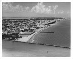 |
| Aerial view looking north from Government Cut showing Greyhound Racetrack in South Shore, 1964 |
|
| Publication Date: | |
1964
|
| Creator: | |
Hansen, Chris ( Photographer )
|
| Publisher.Display: | |
City of Miami Beach News Bureau, ( Miami Beach, Fla. : )
|
| Format: | |
1 photograph : ill. ; 21 x 26 cm.
|
| Subjects.Display: | |
Miami Beach (Fla.)--Pictorial works.
Miami Beach (Fla.)--Buildings, structures, etc.--Pictorial works.
Miami Beach (Fla.)--Aerial photographs.
Beaches--United States--Florida--Miami Beach--1960-1970.
Lummus Park (Miami Beach, Fla.)
Channels--1960-1970.
Racetracks--1960-1970.
Jetties--1960-1970
Government Cut (Miami Beach (Fla.)
|
| Source Institution: | |
City of Miami Beach
|
|
| Aerial view looking north from Government Cut showing Greyhound Racetrack in South Shore, 1964 |
|
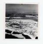 |
| Aerial view of Government Road and salt ponds taken December 19th, 1945 |
|
| Publication Date: | |
1945
|
| Creator: | |
Monroe County Public Library System
May Hill Russell Library -- History Dept
Ida Woodward Barron Collection
|
| Format: | |
1 photograph : b&w ; 7 x 7 in.
|
| Subjects.Display: | |
Photographs -- Key West (Fla.)
Monroe -- 12087
Aerial photographs -- Monroe County (Fla.)
Airports -- Aerial photographs -- Florida -- Key West
Bunkers (Fortification) -- Aerial Photographs -- Florida -- Key West
Roads -- Aerial photographs -- Florida -- Key West
Bridges -- Aerial photographs -- Florida -- Key West
Railroad bridges -- Aerial photographs -- Key West (Fla.)
|
| Source Institution: | |
Florida International University
|
|
| Aerial view of Government Road and salt ponds taken December 19th, 1945 |
|
|
 |
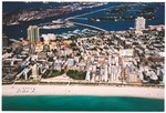
| Aerial view of oceanfront hotels looking north |
|
| Publication Date: | |
1972/1974
|
| Creator: | |
Chris Hansen
Miami Beach Tourist Development Auth. Publicity Dept
|
| Publisher.Display: | |
The City of Miami Beach Tourist Development Authority, Publicity Department
|
| Format: | |
8 x 10 cm
|
| Subjects.Display: | |
Miami Beach (Fla.)--Pictorial works.
Miami Beach (Fla.)--Buildings, structures, etc.--Pictorial works.
Miami Beach (Fla.)--Aerial views.
Miami Beach (Fla.)--Aerial photographs.
Beaches--1970-1980.
Hotels--1970-1980.
|
| Source Institution: | |
City of Miami Beach
|
| Donor: | |
Miami Beach Public Works Department
|
|
Aerial view of oceanfront hotels looking north
( 37 volumes ) |
|
 |
| Aerial view of the southest part of the Miami Beach Golf Club. |
|
| Publication Date: | |
2002
|
| Publisher.Display: | |
City of Miami Beach
|
| Format: | |
Series includes 12 photographs : col. ill. ; 10 x 15 cm.
|
| Subjects.Display: | |
Miami Beach (Fla.)--Pictorial works.
Miami Beach (Fla.)--Aerial views.
Miami (Fla.)--Buildings, structures, etc.--Pictorial works.
Government Cut (Miami Beach, Fla.)--Pictorial works.
|
| Source Institution: | |
City of Miami Beach
|
|
Aerial view of the southest part of the Miami Beach Golf Club.
( 12 volumes ) |
|
|
 |
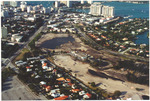
| Aerial views of South Beach, Government Cut, Miami Beach Marina, MacArthur Causeway and Islands, 1990s |
|
| Publication Date: | |
1995
|
| Publisher.Display: | |
City of Miami Beach
|
| Subjects.Display: | |
Miami Beach (Fla.)--Buildings, structures, etc.--Pictorial works.
Miami Beach (Fla.)--Aerial views.
|
| Source Institution: | |
City of Miami Beach
|
|
| Aerial views of South Beach, Government Cut, Miami Beach Marina, MacArthur Causeway and Islands, 1990s |
|
 |
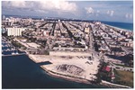
| Aerial views of South Beach, Government Cut, Miami Beach Marina, MacArthur Causeway and Islands, early 2000s |
|
| Publication Date: | |
2000
|
| Subjects.Display: | |
Miami Beach (Fla.)
Miami Beach (Fla.)--Buildings, structures, etc.--Pictorial works.
Miami Beach (Fla.)--Aerial views.
Apartment buildings--United States--Florida--Miami Beach--2000-2010.
Convention facilities--United States--Florida--Miami Beach--Pictorial works.
City halls--2000-2010.
Parks--2000-2010.
Golf courses--2000-2010.
Museums--2000-2010.
Marinas--Pictorial works.
Architecture--United States--Florida--Miami Beach--Art Deco--Pictorial works.
Causeways--2000-2010.
Harbors--2000-2010.
Streets--United States--Florida--Miami Beach--2000-2010.
Beaches--2000-2010.
|
| Source Institution: | |
City of Miami Beach
|
|
| Aerial views of South Beach, Government Cut, Miami Beach Marina, MacArthur Causeway and Islands, early 2000s |
|
|
 |
| Agencies Should Devleop Guidance for Addressing the Effects on Federal Land and Water Resources |
|
| Publication Date: | |
2007-08-07
|
| Creator: | |
United States Government Accountability Office
|
| Publisher.Display: | |
United States Government Accountability Office
|
| Subjects.Display: | |
Climate change
Environmental policy
Water resources
land management
|
| Source Institution: | |
Florida International University
|
|
| Agencies Should Devleop Guidance for Addressing the Effects on Federal Land and Water Resources |
|
 |
| Archaeological Lab in Government House |
|
| Source Institution: | |
University of Florida
|
|
Archaeological Lab in Government House
( 10 volumes ) |
|
|
 |
| Arrivas House and entrance to the Rodriguez-Avero-Sanchez House from St. George Street, looking Northwest |
|
| Publication Date: | |
1963
|
| Publisher.Display: | |
St. Augustine Restoration, Inc.
|
| Source Institution: | |
University of Florida
|
|
Arrivas House and entrance to the Rodriguez-Avero-Sanchez House from St. George Street, looking Northwest
( 82 volumes ) |
|
 |
| The Award of Excellence from the Government Finance Officers Association |
|
| Publication Date: | |
2001-04-14
|
| Subjects.Display: | |
Mayors--Florida--Miami Beach
|
| Source Institution: | |
City of Miami Beach
|
|
| The Award of Excellence from the Government Finance Officers Association |
|
|
 |
| Building resilient cities in the Philippines |
|
| Publication Date: | |
2010
|
| Creator: | |
Disaster Risk Reduction Program, Florida International University (DRR/FIU)
Earthquakes and Megacities Initiative (EMI)
|
| Publisher.Display: | |
Earthquakes and Megacities Initiative (EMI) ( Manila, Philippines )
|
| Subjects.Display: | |
Disaster response and recovery -- Philippines
Risk management -- Philippines
Urban development -- Philippines
|
| Source Institution: | |
Florida International University
|
|
| Building resilient cities in the Philippines |
| Access Restricted |
|
 |
| City employees graduating of Supervisory School |
|
| Publication Date: | |
1961-03-09
|
| Creator: | |
North Miami Police
|
| Format: | |
1 b&w photograph ; 8 x 10 inches
|
| Subjects.Display: | |
Municipal officials and employees -- Training of -- Florida -- North Miami
|
| Source Institution: | |
Greater North Miami Historical Society
|
|
| City employees graduating of Supervisory School |
|
|
 |
| Concept drawing of Government House reconstruction project from the intersection of King Street and St. George Street, looking Northwest, ca. 1969 |
|
| Publication Date: | |
1969
|
| Publisher.Display: | |
St. Augustine Restoration, Inc.
|
| Subjects.Display: | |
Saint Augustine (Fla.)
48 King Street (Saint Augustine, Fla.)
Government House (Saint Augustine, Fla.)
|
| Source Institution: | |
University of Florida
|
|
Concept drawing of Government House reconstruction project from the intersection of King Street and St. George Street, looking Northwest, ca. 1969
( 5 volumes ) |
|
 |
| Convent of the Sisters of St. Joseph on St. George Street, looking Southeast, ca. 1864 |
|
| Publication Date: | |
1870
|
| Publisher.Display: | |
National Archives and Records Office, United States of America
|
| Source Institution: | |
University of Florida
|
|
Convent of the Sisters of St. Joseph on St. George Street, looking Southeast, ca. 1864
( 30 volumes ) |
|
|
 |
| Correspondence and ephemera pertaining to the sale of land in the Chevelier Tract to the federal government and to the creation of Everglades National Park |
|
| Publication Date: | |
1931
|
| Creator: | |
Reclaiming the Everglades
Axelson, Mary McDougal, b. 1891
|
| Format: | |
25 items (35 pages) : ;
|
| Subjects.Display: | |
Everglades (Fla.)
Everglades National Park (Fla.)
Sable, Cape (Fla.)
Ten Thousand Islands (Fla.)
Turner River (Fla.)
|
| Source Institution: | |
Florida International University
|
|
| Correspondence and ephemera pertaining to the sale of land in the Chevelier Tract to the federal government and to the creation of Everglades National Park |
|
 |
| Don Jones, Water Dept. |
|
| Publication Date: | |
1960-1969
|
| Format: | |
1 b&w photograph ; 8 x 10 inches
|
| Subjects.Display: | |
Municipal officials and employees -- Florida -- North Miami
North Miami (Fla). Water Department
Jones, Don
Municipal services--Florida--North Miami -- Florida -- North Miami
|
| Source Institution: | |
Greater North Miami Historical Society
|
|
| Don Jones, Water Dept. |
|
|

