| |
|
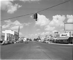 |
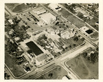
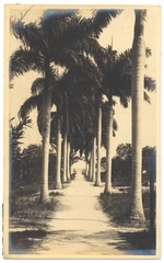
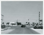
| 125th Street looking west from 6th Avenue in North Miami |
|
| Publication Date: | |
1957?
|
| Format: | |
1 b&w negative; 4x5 inches
|
| Subjects.Display: | |
Roads -- Florida -- North Miami
Stores & shops -- Florida -- North Miami
|
| Source Institution: | |
Greater North Miami Historical Society
|
|
| 125th Street looking west from 6th Avenue in North Miami |
|
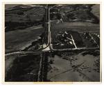 |
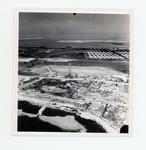
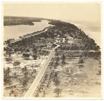
| An aerial photo of the Naval Hosptial site, golf course, and Highway One |
|
| Publication Date: | |
1941
|
| Creator: | |
Monroe County Public Library System
May Hill Russell Library -- History Dept
United States -- Navy
|
| Format: | |
1 photograph : b&w ; 8 x 10 in.
|
| Subjects.Display: | |
Monroe -- 12087
Aerial photographs -- Monroe County (Fla.)
Aerial photographs -- Key West (Fla.)
Roads -- Aerial photographs -- Florida -- Key West
Hospitals, Military -- Aerial photographs -- Florida -- Key West
Golf courses -- Aerial photographs -- Florida -- Key West
|
| Source Institution: | |
Florida International University
|
|
| An aerial photo of the Naval Hosptial site, golf course, and Highway One |
|
|
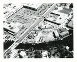 |
| Aerial view of Biscayne Shopping Plaza, NE 79 St. and Biscayne Blvd. |
|
| Publication Date: | |
1950-1959
|
| Format: | |
1 b&w photograph ; 8 x 10 inches
|
| Subjects.Display: | |
Roads -- Florida -- North Miami
Miami (Fla.) -- Aerial views
|
| Source Institution: | |
Greater North Miami Historical Society
|
|
| Aerial view of Biscayne Shopping Plaza, NE 79 St. and Biscayne Blvd. |
|
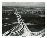 |
| Aerial view of Golden Glades Cloverleaf |
|
| Publication Date: | |
1950-1959
|
| Creator: | |
Ernie's Studio & Camera Center
|
| Format: | |
1 b&w photograph ; 8 x 10 inches
|
| Subjects.Display: | |
Roads -- Florida -- North Miami
Neighborhoods -- Florida -- North Miami
Golden Glades (Fla.) -- Aerial views
|
| Source Institution: | |
Greater North Miami Historical Society
|
|
| Aerial view of Golden Glades Cloverleaf |
|
|
 |
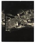
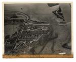
| Aerial view of Government Road and salt ponds taken December 19th, 1945 |
|
| Publication Date: | |
1945
|
| Creator: | |
Monroe County Public Library System
May Hill Russell Library -- History Dept
Ida Woodward Barron Collection
|
| Format: | |
1 photograph : b&w ; 7 x 7 in.
|
| Subjects.Display: | |
Photographs -- Key West (Fla.)
Monroe -- 12087
Aerial photographs -- Monroe County (Fla.)
Airports -- Aerial photographs -- Florida -- Key West
Bunkers (Fortification) -- Aerial Photographs -- Florida -- Key West
Roads -- Aerial photographs -- Florida -- Key West
Bridges -- Aerial photographs -- Florida -- Key West
Railroad bridges -- Aerial photographs -- Key West (Fla.)
|
| Source Institution: | |
Florida International University
|
|
| Aerial view of Government Road and salt ponds taken December 19th, 1945 |
|
 |
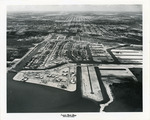
| An aerial view of Key West from White Street to the Airport |
|
| Publication Date: | |
1960/1969
|
| Creator: | |
Monroe County Public Library System
May Hill Russell Library -- History Dept
|
| Format: | |
1 photograph : b&w ; 8 x 10 in.
|
| Subjects.Display: | |
Monroe -- 12087
Aerial photographs -- Monroe County (Fla.)
Aerial photographs -- Key West (Fla.)
Airports -- Aerial photographs -- Florida -- Key West
Roads -- Aerial photographs -- Florida -- Key West
|
| Source Institution: | |
Florida International University
|
| Donor: | |
Westray, Bill
|
|
| An aerial view of Key West from White Street to the Airport |
|
|
 |
| Aerial view of Keystone Islands in North Miami |
|
| Publication Date: | |
1950-1959
|
| Creator: | |
Ernie's Studio & Camera Center
|
| Format: | |
1 b&w photograph ; 8 x 10 inches
|
| Subjects.Display: | |
Roads -- Florida -- North Miami
North Miami (Fla.) -- Aerial views
Neighborhoods -- Florida -- North Miami
Keystone Islands (North Miami, Fla.)
|
| Source Institution: | |
Greater North Miami Historical Society
|
|
| Aerial view of Keystone Islands in North Miami |
|
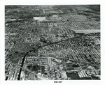 |
| Aerial view of North Miami |
|
| Publication Date: | |
1950-1959
|
| Creator: | |
Ernie's Studio & Camera Center
|
| Format: | |
1 b&w photograph ; 8 x 10 inches
|
| Subjects.Display: | |
Roads -- Florida -- North Miami
North Miami (Fla.) -- Aerial views
Neighborhoods -- Florida -- North Miami
|
| Source Institution: | |
Greater North Miami Historical Society
|
|
| Aerial view of North Miami |
|
|
 |
| Aerial view of North Miami Downtown |
|
| Publication Date: | |
1950-1959
|
| Format: | |
1 b&w photograph ; 8 x 10 inches
|
| Subjects.Display: | |
Roads -- Florida -- North Miami
North Miami (Fla.) -- Aerial views
Neighborhoods -- Florida -- North Miami
|
| Source Institution: | |
Greater North Miami Historical Society
|
|
| Aerial view of North Miami Downtown |
|
 |
| Aerial view of the Firestone Estate and Pancoast House |
|
| Publication Date: | |
1932
|
| Format: | |
1 photograph : ill. ; 20 x 25 cm.
|
| Measurements: | |
20 x 25
|
| Subjects.Display: | |
Miami Beach (Fla.)--Aerial photographs.
Mansions--United States--Florida--Miami Beach--1910-1940.
Historic houses--Pictorial works.
Estates--United States--Florida--Miami Beach--1920-1940.
Palms--United States--Florida—Miami Beach--1920-1940.
Roads--Florida--Miami Beach--1920-1940.
Beaches--United States--Florida--Miami Beach--1920-1940.
Houses--United States--Florida--Miami Beach--1920-1940.
|
| Source Institution: | |
City of Miami Beach
|
|
| Aerial view of the Firestone Estate and Pancoast House |
|
|
 |
| An aerial view of the Naval Hosptial site, Casa Roma, North Roosevelt, and Highway One |
|
| Publication Date: | |
1941
|
| Creator: | |
Monroe County Public Library System
May Hill Russell Library -- History Dept
United States -- Navy
|
| Format: | |
1 photograph : b&w ; 8 x 10 in.
|
| Subjects.Display: | |
Monroe -- 12087
Aerial photographs -- Monroe County (Fla.)
Aerial photographs -- Key West (Fla.)
Hotels -- Aerial photographs -- Florida -- Key West
Roads -- Aerial photographs -- Florida -- Key West
Hospitals, Military -- Aerial photographs -- Florida -- Key West
|
| Source Institution: | |
Florida International University
|
|
| An aerial view of the Naval Hosptial site, Casa Roma, North Roosevelt, and Highway One |
|
 |
| Aerial views of the City of Miami Beach and the City of Miami 1960-1970 |
|
| Publication Date: | |
1966
|
| Creator: | |
Chris Hansen ( Photographer )
|
| Format: | |
30 photographs : col. ill. ; 18 x 13 cm.
|
| Measurements: | |
18 x 13
|
| Subjects.Display: | |
Miami Beach (Fla.)
Miami (Fla.)
Indian Creek (Miami Beach, Fla.)
Miami Beach (Fla.)--Buildings, structures, etc.--Pictorial works.
Miami Beach (Fla.)--Aerial views.
Miami Beach (Fla.)--Aerial photographs.
Miami (Fla.)--Pictorial works.
Fontainebleau (Miami Beach, Fla.)
Government Cut--Pictorial works.
Streets--United States--Florida--Miami Beach--1960-1970.
Beaches--United States--Florida--Miami Beach--1960-1970.
Parks--United States--Florida--Miami Beach--1960-1970.
Hotels--United States--Florida--Miami Beach--1960-1970.
Causeways--1960-1970.
Bridges--1960-1970.
Construction--1960-1970.
Collins Avenue (Miami Beach, Fla.)--1960-1970.
Real estate development--United States--Florida--Miami Beach--1960-1970.
Eden Roc Hotel (Miami Beach, Fla.)
Lakes & ponds--United States--Florida--Miami Beach--1960-1970.
Roads--Florid--Miami Beach--1960-1970.
|
| Source Institution: | |
Miami Beach Digital Archive
|
|
| Aerial views of the City of Miami Beach and the City of Miami 1960-1970 |
|
|
 |
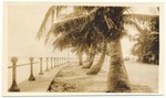
| Alton Beach and Environs |
|
| Publication Date: | |
1916
|
| Creator: | |
Fisher, Carl G.
|
| Format: | |
2 photographs : ill. ; 20 x 12 cm.
|
| Measurements: | |
20 x 12
|
| Subjects.Display: | |
Miami Beach (Fla.)--Pictorial works.
Coconut Grove (Miami, Fla.)--Pictorial works.
Causeways--1910-1920.
Roads--1910-1920.
Palms--1910-1920.
|
| Source Institution: | |
City of Miami Beach
|
|
| Alton Beach and Environs |
|
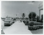 |
| American National Bank, NE 125 St. and 10 Ave. in North Miami |
|
| Publication Date: | |
1957-06-17
|
| Format: | |
1 b&w photograph ; 8 x 10 inches
|
| Subjects.Display: | |
Roads -- Florida -- North Miami
Banks and banking -- Florida -- North Miami
|
| Source Institution: | |
Greater North Miami Historical Society
|
|
| American National Bank, NE 125 St. and 10 Ave. in North Miami |
|
|
 |
| Application Florida Historical Marker, March 2002 |
|
| Publication Date: | |
2002-03-01
|
| Creator: | |
Florida. Bureau of Historic Preservation
North Miami Beach (Fla.). Community Development Department
Vageline, Thomas V.
|
| Format: | |
8 pages : map
|
| Subjects.Display: | |
Arch Creek (Fla.)
Roads -- Florida -- Miami
Historic sites -- Florida -- Miami
Military trails
|
| Source Institution: | |
Arch Creek Trust
|
|
| Application Florida Historical Marker, March 2002 |
|
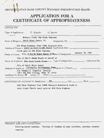 |
| Application for a Certificate of Appropriateness : Military Trail / Old Dixie Highway |
|
| Publication Date: | |
1995
|
| Creator: | |
Arch Creek Trust, Inc.
Metropolitan Dade County (Fla.). Historic Preservation Board
North Miami Beach (Fla.). Community Development Department
Vageline, Thomas V.
|
| Format: | |
6 pages
|
| Subjects.Display: | |
Arch Creek (Fla.)
Roads -- Maintenance and repair -- Florida -- Miami
Street signs -- Installation -- Florida -- Miami
Military trails
|
| Source Institution: | |
Arch Creek Trust
|
|
| Application for a Certificate of Appropriateness : Military Trail / Old Dixie Highway |
|
|
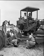 |
| Attendees to the Causeway groundbreaking ceremony inspect construction equipment |
|
| Publication Date: | |
1951-07-14
|
| Format: | |
1 b&w negative; 4x5 inches
|
| Subjects.Display: | |
Roads -- Florida -- North Miami
Causeways -- Florida -- North Miami
Broad Causeway Bridge (Miami, Fla.)
|
| Source Institution: | |
Greater North Miami Historical Society
|
|
| Attendees to the Causeway groundbreaking ceremony inspect construction equipment |
|
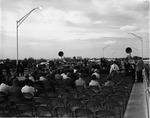 |
| Audience at the dedication of NW 7th Ave project |
|
| Publication Date: | |
1960-12-09
|
| Format: | |
1 b&w negative; 4x5 inches
|
| Subjects.Display: | |
Roads -- Florida -- North Miami
Special events -- Florida -- North Miami
Public works -- Florida -- North Miami
|
| Source Institution: | |
Greater North Miami Historical Society
|
|
| Audience at the dedication of NW 7th Ave project |
|
|
 |
| Automatic Gas, 13090 NW 7 Avenue in North Miami |
|
| Publication Date: | |
1958-06-16
|
| Format: | |
1 b&w photograph ; 8 x 10 inches
|
| Subjects.Display: | |
Roads -- Florida -- North Miami
Stores & shops -- Florida -- North Miami
|
| Source Institution: | |
Greater North Miami Historical Society
|
|
| Automatic Gas, 13090 NW 7 Avenue in North Miami |
|
 |
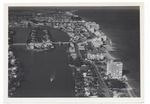
| Bayshore Drive, Blue Stone Apartments, and the Miami Harbor |
|
| Publication Date: | |
1925
|
| Format: | |
4 photographs: ill. ; [various sizes, largest: 11 x 7 cm].
|
| Measurements: | |
11 x 7
|
| Subjects.Display: | |
Miami Beach (Fla.)--Buildings, structures, etc.--Pictorial works.
Palms--1920-1930.
Harbors--1920-1930.
Apartments--1920-1930.
Miami (Fla.)--Building, structures, etc.--Pictorial works.
Dirt roads--United States--Florida--Miami Beach--1920-1930.
Ships--1920-1930.
|
| Source Institution: | |
City of Miami Beach
|
|
| Bayshore Drive, Blue Stone Apartments, and the Miami Harbor |
|

