| |
|
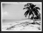 |
| Cape Sable, 1928-1929 |
|
| Publication Date: | |
1928/1929
|
| Creator: | |
Matlack, Claude Carson, 1878-1944.
|
| Format: | |
17 photos. : black and white; 18 x 13 cm.
|
| Subjects.Display: | |
Everglades
Sable, Cape (Fla.)
Everglades (Fla.)--Photographs
Monroe--12087--ceeus
Middle Cape (Cape Sable, Fla.)
Waddell Grove (Cape Sable, Fla.)
Coconut palm--Florida--Everglades
Children--Florida--Everglades
|
| Source Institution: | |
Florida International University
|
|
| Cape Sable, 1928-1929 |
|
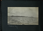 |
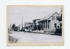
| Chokoloskee Bay and environs, and the Ten Thousand Islands, 1911. |
|
| Publication Date: | |
1911
|
| Creator: | |
Cornell, Lynn Grady.
|
| Format: | |
11 photos. : black and white.
|
| Subjects.Display: | |
Watson Place (Fla.)
Monroe--12087--ceeus
Everglades (Fla.)--Photographs.
Everglades City (Fla.)
Collier--12021--ceeus
Ten Thousand Islands (Fla.)
Chokoloskee Bay region (Fla.)
Seminole Indians--Photographs.
Epiphytes.
Harney River (Fla.)
Marco Island (Fla. : Island)
Rabbit Key (Fla.)
Tiger Key (Fla.)
|
| Source Institution: | |
Florida International University
|
|
| Chokoloskee Bay and environs, and the Ten Thousand Islands, 1911. |
|
|
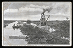 |
| Dredges, dredging and canals in the Everglades, 1906?-1913? |
|
| Format: | |
7 postcards : col.
|
| Subjects.Display: | |
Everglades (Fla.)
Miami Canal (Fla.)
Dredges--Florida--Everglades.
Monroe--12087--ceeus
Moore Haven (Fla.)
Canals--Florida--Everglades.
Glades--12043--ceeus
Duval--12031--ceeus
|
| Source Institution: | |
Florida International University
|
|
| Dredges, dredging and canals in the Everglades, 1906?-1913? |
|
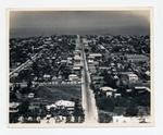 |
| Duval from South street looking north west |
|
| Publication Date: | |
1930
|
| Creator: | |
Monroe County Public Library System. ( Contributor )
PALMM (Project) ( Contributor )
May Hill Russell Library. History Dept. ( Contributor )
Aero-Graphic Corp.
|
| Format: | |
1 photograph : b&w; 8 x 10 in.
|
| Subjects.Display: | |
Monroe--12087--ceeus
Key West (Fla.)--Aerial photographs.
Monroe County (Fla.)--Aerial photographs.
Roads--Florida--Key West--Aerial photographs.
|
| Source Institution: | |
Florida International University
|
|
| Duval from South street looking north west |
|
|
 |
| Flamingo and Cape Sable (Everglades, Fla.), circa 1900-1925. |
|
| Publication Date: | |
1925
|
| Format: | |
3 photos. : black and white
|
| Subjects.Display: | |
Sable, Cape (Fla.)
Monroe--12087--ceeus
Everglades (Fla.)--Photographs.
Roberts family.
Flamingo (Fla.)
Bradley, Guy,--1870-1905.
|
| Source Institution: | |
Florida International University
|
|
| Flamingo and Cape Sable (Everglades, Fla.), circa 1900-1925. |
|
 |
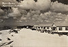
| James Street looking east from 1016 to 1024 |
|
| Publication Date: | |
1935
|
| Creator: | |
Monroe County Public Library System. ( Contributor )
PALMM (Project) ( Contributor )
Old Island Restoration Foundation. ( Contributor )
May Hill Russell Library. ( Contributor )
|
| Format: | |
1 photograph : b&w ; 5 x 7 in.
|
| Subjects.Display: | |
Monroe--12087--ceeus
Monroe County (Fla.)--Photographs.
Pineapple industry--Florida--Key West--Photographs.
Letter carriers--Florida--Key West--Photographs.
Key West (Fla.)--Photographs.
|
| Source Institution: | |
Florida International University
|
|
| James Street looking east from 1016 to 1024 |
|
|
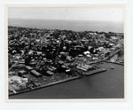 |
| Mallory Square and Truman Annex looking southeast |
|
| Publication Date: | |
1972
|
| Creator: | |
Monroe County Public Library System. ( Contributor )
PALMM (Project) ( Contributor )
May Hill Russell Library. History Dept. ( Contributor )
Ida Woodward Barron Collection. ( Contributor )
|
| Format: | |
1 photograph : b&w; 8 x 10 in.
|
| Subjects.Display: | |
Monroe--12087--ceeus
Docks--Florida--Key West--Aerial photographs.
Streets--Florida--Key West--Aerial photographs.
Key West (Fla.)--Buildings, structures, etc.--Aerial photographs.
Key West (Fla.)--Aerial photographs.
Monroe County (Fla.)--Aerial photographs.
|
| Source Institution: | |
Florida International University
|
|
| Mallory Square and Truman Annex looking southeast |
|
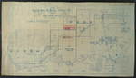 |
| Map showing special road and bridges, Cape Sable District, Monroe County, 1920 |
|
| Publication Date: | |
1920
|
| Creator: | |
Livingston, A. R.
|
| Format: | |
1 map.
|
| Subjects.Display: | |
Monroe--12087--ceeus
Ingraham Highway (Fla.)
Everglades (Fla.)--Maps.
Jennings Tract (Fla.)
Monroe County (Fla.)--Maps.
Sable, Cape (Fla.)--Maps.
|
| Source Institution: | |
Florida International University
|
|
| Map showing special road and bridges, Cape Sable District, Monroe County, 1920 |
|
|
 |
| Rest Beach, Key West |
|
| Publication Date: | |
1939
|
| Creator: | |
Monroe County Public Library System. ( Contributor )
PALMM (Project) ( Contributor )
May Hill Russell Library. History Dept. ( Contributor )
|
| Format: | |
1 photograph : b&w ; 2 x 3 in.
|
| Subjects.Display: | |
Monroe--12087--ceeus
Monroe County (Fla.)--Photographs.
Key West (Fla.)--Photographs.
Vacation homes--Florida--Key West--Photographs.
Shorelines--Key West (Fla.)--Photographs.
Rest Beach (Key West, Fla.)--Photographs.
|
| Source Institution: | |
Florida International University
|
|
| Rest Beach, Key West |
|
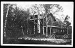 |
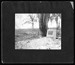
| Royal Palm State Park, 1921. |
|
| Publication Date: | |
1921
|
| Format: | |
4 photos. : black and white.
|
| Subjects.Display: | |
Everglades (Fla.)--Photographs
Monroe--12087--ceeus
Ingraham Highway (Fla.)
Paradise Key (Fla.)
Royal Palm State Park (Fla.)
|
| Source Institution: | |
Florida International University
|
|
| Royal Palm State Park, 1921. |
|
|
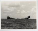 |
| The sinking of the USS Wilkes Barre to be used as a reef |
|
| Publication Date: | |
1972
|
| Creator: | |
Monroe County Public Library System. ( Contributor )
PALMM (Project) ( Contributor )
May Hill Russell Library. History Dept. ( Contributor )
Ida Woodward Barron Collection. ( Contributor )
|
| Format: | |
1 photograph : b&w ; 8 x 10 in.
|
| Subjects.Display: | |
Monroe--12087--ceeus
Monroe County (Fla.)--Photographs.
Key West (Fla.)--Photographs.
Wilkes Barre (Destroyer)--Photographs.
Destroyers (Warships)--Florida--Key West--Photographs.
|
| Source Institution: | |
Florida International University
|
|
| The sinking of the USS Wilkes Barre to be used as a reef |
|
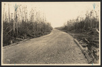 |
| Tamiami Trail and Loop Road photographs, 1920s |
|
| Publication Date: | |
1920/1929
|
| Format: | |
5 photos. : black and white
|
| Subjects.Display: | |
Everglades (Fla.)
Tamiami Trail (Fla.)
Loop Road (Fla.)
Pinecrest (Fla.)
Poinciana Trail (Fla.)
Monroe--12087--ceeus
|
| Source Institution: | |
Florida International University
|
|
| Tamiami Trail and Loop Road photographs, 1920s |
|
|
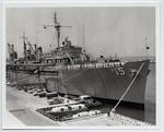 |
| USS Bushnell in Key West |
|
| Publication Date: | |
1969
|
| Creator: | |
Monroe County Public Library System. ( Contributor )
PALMM (Project) ( Contributor )
May Hill Russell Library. History Dept. ( Contributor )
Ida Woodward Barron Collection. ( Contributor )
|
| Format: | |
1 photograph : b&w ; 8 x 10 in.
|
| Subjects.Display: | |
Monroe--12087--ceeus
Monroe County (Fla.)--Photographs.
Key West (Fla.)--Photographs.
Naval station Key West (Fla.)--Photographs.
Destroyers (Warships)--Florida--Key West--Photographs.
Bushnell (Destroyer)--Photographs.
|
| Source Institution: | |
Florida International University
|
|
| USS Bushnell in Key West |
|
|

