| |
|
 |
| An atlas of surface water management basins in the Everglades: THE WATER CONSERVATION AREAS AND EVERGLADES NATIONAL PARK |
|
| Creator: | |
South Florida Water Management District (Fla.) -- Dept. of Research and Evaluation
Cooper, Richard M
Roy, Joanne
|
| Publisher.Display: | |
Water Resources Engineering Division, Dept. of Research and Evaluation, South Florida Water Management District ( West Palm Beach, Fla )
|
| Format: | |
viii, 88 p. : maps ; 28 cm.
|
| Subjects.Display: | |
Everglades (Fla.)
Everglades National Park (Fla.)
Water resources development ( lcsh )
Watersheds -- Maps ( lcsh )
Watershed management ( lcsh )
|
| Source Institution: | |
Florida International University
|
|
| An atlas of surface water management basins in the Everglades: THE WATER CONSERVATION AREAS AND EVERGLADES NATIONAL PARK |
|
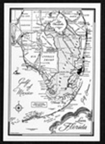 |
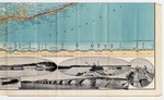
| Everglades and Big Cypress postcard. |
|
| Creator: | |
Douglas, Marjory Stoneman
|
| Format: | |
1 item.
|
| Subjects.Display: | |
Everglades (Fla.)--Maps.
|
| Source Institution: | |
Florida International University
|
|
| Everglades and Big Cypress postcard. |
|
|
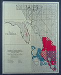 |
| Map of Florida 500,000 acres choice prairie farming lands in Florida. |
|
| Creator: | |
Moore-Willson, Minnie, b. 1863. ( Contributor )
Southern Colonization Company.
|
| Publisher.Display: | |
Southern Colonization Company
|
| Format: | |
1 map.
|
| Subjects.Display: | |
Everglades (Fla.)--Maps.
Real estate development--Florida--Everglades.
Florida--Maps.
|
| Source Institution: | |
Florida International University
|
|
| Map of Florida 500,000 acres choice prairie farming lands in Florida. |
|
![Map of South Florida. 19--]](http://dpanther.fiu.edu/sobek/content/MW/00/99/00/02/00001/001a_thm.jpg) |
| Map of South Florida. 19--] |
|
| Creator: | |
Moore-Willson, Minnie, b. 1863. ( Contributor )
|
| Format: | |
1 map.
|
| Subjects.Display: | |
Everglades (Fla.)--Maps.
|
| Source Institution: | |
Florida International University
|
|
| Map of South Florida. 19--] |
|
|
![For sale Fertile Florida lands in large tracts. 19--]](http://dpanther.fiu.edu/sobek/content/MW/00/99/00/01/00001/001a_thm.jpg) |
| For sale Fertile Florida lands in large tracts. 19--] |
|
| Creator: | |
Moore-Willson, Minnie, b. 1863. ( Contributor )
Hedges, George T. ( Contributor )
|
| Publisher.Display: | |
George T. Hedges & Company.
|
| Format: | |
1 map
|
| Subjects.Display: | |
Everglades (Fla.)--Maps.
Real estate development--Florida--Everglades.
George T. Hedges & Company.
|
| Source Institution: | |
Florida International University
|
|
| For sale Fertile Florida lands in large tracts. 19--] |
|
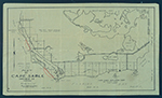 |
| Map of Cape Sable. |
|
| Creator: | |
Model Land Company.
|
| Format: | |
1 item.
|
| Subjects.Display: | |
Sable, Cape (Fla.)--Maps.
|
| Source Institution: | |
Florida International University
|
|
| Map of Cape Sable. |
|
|
 |
| Maps and letter relating to Cape Sable and Monroe County, Fla., 1927-1930. |
|
| Creator: | |
Model Land Company.
Bowen, Reeves. ( Contributor )
Hoffman, J. W. ( Contributor )
|
| Format: | |
3 items
|
| Subjects.Display: | |
Sable, Cape (Fla.)
Everglades (Fla.)--Maps.
|
| Source Institution: | |
Florida International University
|
|
| Maps and letter relating to Cape Sable and Monroe County, Fla., 1927-1930. |
|
 |
| Hydrogeologic reconnaissance of the Floridan aquifer system, Upper East Coast Planning Area |
|
| Creator: | |
South Florida Water Management District. ( Contributor )
Brown, Michael P.
Reece, Dennis.
|
| Format: | |
11 maps : col. ; 58 x 84 cm. folded in envelope 27 x 34 cm.
|
| Subjects.Display: | |
Water quality -- Florida -- Upper East Coast Planning Area -- Maps.
Aquifers -- Florida -- Upper East Coast Planning Area -- Maps.
Groundwater -- Florida -- Upper East Coast Planning Area -- Maps.
|
| Source Institution: | |
Florida International University
|
|
| Hydrogeologic reconnaissance of the Floridan aquifer system, Upper East Coast Planning Area |
|
|
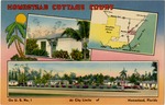 |
| Homestead Cottage Court |
|
| Creator: | |
Colourpicture ( Contributor )
|
| Format: | |
1 picture postcard; 8.9 x 13.8 cm.
|
| Subjects.Display: | |
Homestead (Fla.)
Florida--Miami--Maps
Cottages--Florida--Miami
|
| Source Institution: | |
Florida International University
|
|
| Homestead Cottage Court |
|
 |
| 2 vittorie |
|
| Creator: | |
Gambini, Ivanhoe, 1904-1992.
Galleria Nazionale d'Arte Moderna, Milano. ( Contributor )
|
| Format: | |
1 postcard : col. ill. ; 11 x 15 cm.
|
| Subjects.Display: | |
Futurism (Art)--Italy
Aeropittura--Italy
Airplanes in art
Artists--Italy--20th century
Seaplanes--Italy--1920-1930
Fascism in art
Italy--Maps, Pictorial
|
| Source Institution: | |
Florida International University
|
|
| 2 vittorie |
|
|
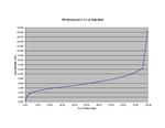 |
| South Beach Hypsographic Curve (Adjusted) |
|
| Creator: | |
Harlem,Peter
|
| Subjects.Display: | |
Florida
Maps
Hypsographic maps
|
| Source Institution: | |
Florida International University
|
|
| South Beach Hypsographic Curve (Adjusted) |
|
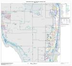 |
| Urbanized area outline map (Census 2000) |
|
| Creator: | |
U.S. Census Bureau
|
| Format: | |
pdf
|
| Subjects.Display: | |
Miami-Dade County (Fla.)
Metropolitan areas.
Metropolitan areas -- Florida -- Miami-Dade County.
Census districts -- Florida -- Miami-Dade County -- Maps.
|
| Source Institution: | |
South Florida Collection, Government Documents, Green Library, Florida International University
|
|
| Urbanized area outline map (Census 2000) |
|
|
 |
| Virginia Key Beach Restoration Project Survey Map |
|
| Creator: | |
unknown
|
| Subjects.Display: | |
Virginia Key Beach Park (Miami, Fla.)
Historical geography--Maps
United States--Historical geography--Maps
|
| Source Institution: | |
Virginia Key Beach Park Trust
|
|
| Virginia Key Beach Restoration Project Survey Map |
|
 |
| Virginia Beach Flora Restoration Project Map One |
|
| Creator: | |
unknown
|
| Subjects.Display: | |
Virginia Key Beach Park (Miami, Fla.)
Historical geography--Maps
|
| Source Institution: | |
Virginia Key Beach Park Trust
|
|
| Virginia Beach Flora Restoration Project Map One |
|
|
 |
| Preliminary Drawing for the Virginia Key Beach Restoration Project |
|
| Subjects.Display: | |
Virginia Key Beach Park (Miami, Fla.)
United States--Historical geography--Maps
|
| Source Institution: | |
Virginia Key Beach Park Trust
|
|
| Preliminary Drawing for the Virginia Key Beach Restoration Project |
|
 |
| Map of Miami to Key West |
|
| Format: | |
Undetermined
|
| Subjects.Display: | |
Florida--Key West
Advertising--Maps
|
| Source Institution: | |
Florida International University
|
|
| Map of Miami to Key West |
|
|
 |
| Map of Miami to Key West |
|
| Format: | |
Undetermined
|
| Subjects.Display: | |
Florida--Key West
Advertising--Maps
|
| Source Institution: | |
Florida International University
|
|
| Map of Miami to Key West |
|
![[1936-08] Amended Plat Journey's End](http://dpanther.fiu.edu/sobek/content/FI/14/03/11/30/00001/FI14031130_thm.jpg) |
| Amended Plat Journey's End |
|
| Publication Date: | |
1936-08
|
| Creator: | |
Watson & Garris,Civil Engineers, Inc.
|
| Format: | |
map
|
| Subjects.Display: | |
Coral Gables (Fla.)
Miami-Dade County (Fla.)
Real property--Maps
Cadastral maps
Plat books
|
| Source Institution: | |
Florida International University
|
|
| [1936-08] Amended Plat Journey's End |
|
|
![[5/13/1884] Township Map of Virginia Key and Key Biscayne](http://dpanther.fiu.edu/sobek/content/FI/VK/04/49/93/00001/FIVK044993thm.jpg) |
| Township Map of Virginia Key and Key Biscayne |
|
| Publication Date: | |
5/13/1884
|
| Creator: | |
Florida Surveyor General's Office
|
| Subjects.Display: | |
Virginia Key Beach Park (Miami, Fla.)
Historical geography--Maps
United States--Historical geography--Maps
|
| Source Institution: | |
Virginia Key Beach Park Trust
|
|
| [5/13/1884] Township Map of Virginia Key and Key Biscayne |
|
![[1891/1895] General Topographical Map Sheet XI](http://dpanther.fiu.edu/sobek/content/FI/07/04/25/12/00001/FI07042512_thm.jpg) |
| General Topographical Map Sheet XI |
|
| Publication Date: | |
1891/1895
|
| Creator: | |
United States. War Department.
Julius Bien & Co.
|
| Publisher.Display: | |
Washington: G.P.O.
|
| Format: | |
1 map : col. ; 41 x 69 cm.
|
| Subjects.Display: | |
Florida
Florida, U.S.A.
Railroads
Military bases
Swamps
History -- Civil War, 1861-1865
United States -- History -- Civil War, 1861-1865
Maps -- Florida
|
| Source Institution: | |
Florida International University
|
|
| [1891/1895] General Topographical Map Sheet XI |
|

