| |
|
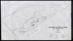 |
| 1953 Historic Plan for Virginia Key Beach Park |
|
| Publication Date: | |
1953
|
| Creator: | |
unknown
|
| Subjects.Display: | |
Virginia Key Beach Park (Miami, Fla.)
Historical geography--Maps
United States--Historical geography--Maps
|
| Source Institution: | |
Virginia Key Beach Park Trust
|
|
| 1953 Historic Plan for Virginia Key Beach Park |
|
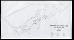 |
| 1954 Historic Plan for Virginia Key Beach Park |
|
| Publication Date: | |
1953
|
| Creator: | |
unknown
|
| Subjects.Display: | |
Virginia Key Beach Park (Miami, Fla.)
Historical geography--Maps
United States--Historical geography--Maps
|
| Source Institution: | |
Virginia Key Beach Park Trust
|
|
| 1954 Historic Plan for Virginia Key Beach Park |
|
|
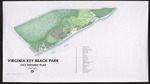 |
| Colorized Wallace, Roberts, and Todd LLC. Virginia Key Beach Park 1953 Historic Plan |
|
| Publication Date: | |
1953
|
| Creator: | |
Wallace, Roberts, and Todd LLC.
|
| Subjects.Display: | |
Virginia Key Beach Park (Miami, Fla.)
Historical geography--Maps
United States--Historical geography--Maps
|
| Source Institution: | |
Virginia Key Beach Park Trust
|
|
| Colorized Wallace, Roberts, and Todd LLC. Virginia Key Beach Park 1953 Historic Plan |
|
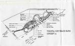 |
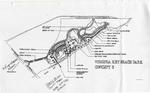
| Concept A Plan for Virginia Key Beach Park |
|
| Creator: | |
unknown
|
| Subjects.Display: | |
City planning
Virginia Key Beach Park (Miami, Fla.)
|
| Source Institution: | |
Virginia Key Beach Park Trust
|
|
| Concept A Plan for Virginia Key Beach Park |
|
|
 |
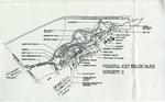
| Concept B Plan for Virginia Key Beach Park |
|
| Creator: | |
unknown
|
| Subjects.Display: | |
City planning
Virginia Key Beach Park (Miami, Fla.)
|
| Source Institution: | |
Virginia Key Beach Park Trust
|
|
| Concept B Plan for Virginia Key Beach Park |
|
 |
| Concept C Plan for Virginia Key Beach Park |
|
| Creator: | |
unknown
|
| Subjects.Display: | |
City planning
Virginia Key Beach Park (Miami, Fla.)
|
| Source Institution: | |
Virginia Key Beach Park Trust
|
|
| Concept C Plan for Virginia Key Beach Park |
|
|
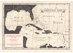 |
| Hurricane Area Map |
|
| Publication Date: | |
1935
|
| Creator: | |
Washington Storage Co., Inc.
|
| Format: | |
1 map : ill ; 34 x 24 cm.
|
| Measurements: | |
34 x 24
|
| Subjects.Display: | |
Hurricanes--Atlantic Coast (U.S.).
Maps--1920-1940.
Hurricanes--Caribbean Area.
Hurricanes--Gulf Coast (U.S.)
|
| Source Institution: | |
City of Miami Beach
|
|
| Hurricane Area Map |
|
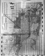 |
| Larson's map of Greater Miami |
|
| Publication Date: | |
1956-03-16
|
| Publisher.Display: | |
Larson's Enterprise ( Coral Gables, Fla. )
|
| Format: | |
1 b&w negative; 4x5 inches
|
| Subjects.Display: | |
Miami (Fla.) -- Maps
|
| Source Institution: | |
Greater North Miami Historical Society
|
|
| Larson's map of Greater Miami |
|
|
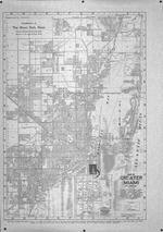 |
| Map of Greater Miami Florida |
|
| Publication Date: | |
1939?
|
| Creator: | |
Miami Daily News
|
| Publisher.Display: | |
Dolph, Stewart & Miller ( New York )
|
| Format: | |
1 b&w map
|
| Subjects.Display: | |
Miami (Fla.) -- Maps
|
| Source Institution: | |
Greater North Miami Historical Society
|
|
| Map of Greater Miami Florida |
|
 |
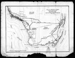
| Map of the Virginia Key Abandoned Military Reservation |
|
| Publication Date: | |
5/18/1918
|
| Creator: | |
United States Department of the Interior
|
| Subjects.Display: | |
Virginia Key Beach Park (Miami, Fla.)
Historical geography--Maps
United States--Historical geography--Maps
|
| Source Institution: | |
Virginia Key Beach Park Trust
|
|
| Map of the Virginia Key Abandoned Military Reservation |
|
|
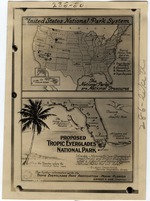 |
| Map of U.S. National Parks |
|
| Publication Date: | |
1929
|
| Creator: | |
Matlack, Claude Carson ( Photographer )
|
| Format: | |
8 x 10" Black and white print
|
| Source Institution: | |
HistoryMiami Museum
|
|
| Map of U.S. National Parks |
|
 |
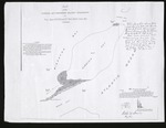
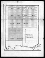
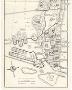
| Maps and documents relating to property in the proposed town of Poinciana |
|
| Publication Date: | |
1925/1929
|
| Creator: | |
Reclaiming the Everglades
Smith, Loren E
|
| Format: | |
6 items. : ;
|
| Subjects.Display: | |
Real estate development -- Florida -- Everglades
Maps -- Everglades (Fla.)
Lostman's River (Fla.)
Onion Key (Fla.)
Poinciana (Fla.)
|
| Source Institution: | |
Florida International University
|
|
| Maps and documents relating to property in the proposed town of Poinciana |
|
|
 |
| Maps and documents relating to property in the proposed town of Poinciana |
|
| Publication Date: | |
1925/1929
|
| Creator: | |
Reclaiming the Everglades
Smith, Loren E
|
| Format: | |
6 items. : ;
|
| Subjects.Display: | |
Real estate development -- Florida -- Everglades
Maps -- Everglades (Fla.)
Lostman's River (Fla.)
Onion Key (Fla.)
Poinciana (Fla.)
|
| Source Institution: | |
Florida International University
|
|
| Maps and documents relating to property in the proposed town of Poinciana |
|
 |
| MB 967 1 |
|
| Publication Date: | |
1968
|
| Creator: | |
Miami Beach Public Relations Dept.
|
| Subjects.Display: | |
City councils
Municipal bonds--Law and legislation
|
| Source Institution: | |
City of Miami Beach
|
|
MB 967 1
( 7 volumes ) |
|
|
 |
| Model City Community Revitalization District Trust and Model City / Brownsville Charrette Areas |
|
| Publication Date: | |
2003
|
| Creator: | |
South Florida Regional Planning Council
|
| Publisher.Display: | |
South Florida Regional Planning Council ( Florida -- Miami-Dade County )
|
| Format: | |
pdf
|
| Subjects.Display: | |
City planning
Zoning
Florida -- Miami -- Model City
Inner cities
|
| Source Institution: | |
South Florida Collection, Government Resources and Information Department, Florida International University Green Library
|
|
| Model City Community Revitalization District Trust and Model City / Brownsville Charrette Areas |
|
 |
| North Miami Beach and Vicinity |
|
| Publication Date: | |
1939-07-20
|
| Publisher.Display: | |
U.S. Coast and Geodetic Survey
|
| Format: | |
1 b&w map
|
| Subjects.Display: | |
Miami (Fla.) -- Maps
North Miami Beach (Fla.) -- Maps
|
| Source Institution: | |
Greater North Miami Historical Society
|
|
| North Miami Beach and Vicinity |
|
|
 |
| Opa Locka Quadrangle, Florida |
|
| Publication Date: | |
1949
|
| Publisher.Display: | |
Geological Survey (U.S.)
|
| Format: | |
1 b&w map
|
| Subjects.Display: | |
Opa-Locka (Fla.) -- Maps
|
| Source Institution: | |
Greater North Miami Historical Society
|
|
| Opa Locka Quadrangle, Florida |
|
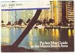 |
| Pocket map guide to the Miami Beach area |
|
| Publication Date: | |
1970
|
| Publisher.Display: | |
Miami Beach Tourist Development Authority, ( Miami Beach, Fla. )
|
| Format: | |
1 leaflet, 3p : ill. ; 9 x 13 cm.
|
| Measurements: | |
9 x 13
|
| Subjects.Display: | |
Miami Beach (Fla.)--Pictorial works.
Miami Beach (Fla.)--Buildings, structures, etc.--Pictorial works.
Miami Beach (Fla.)--Maps.
|
| Source Institution: | |
City of Miami Beach
|
|
| Pocket map guide to the Miami Beach area |
|
|
 |
| Township Map of Virginia Key and Key Biscayne |
|
| Publication Date: | |
5/13/1884
|
| Creator: | |
Florida Surveyor General's Office
|
| Subjects.Display: | |
Virginia Key Beach Park (Miami, Fla.)
Historical geography--Maps
United States--Historical geography--Maps
|
| Source Institution: | |
Virginia Key Beach Park Trust
|
|
| Township Map of Virginia Key and Key Biscayne |
|
 |
| Virginia Beach Flora Restoration Project Map One |
|
| Creator: | |
unknown
|
| Subjects.Display: | |
Virginia Key Beach Park (Miami, Fla.)
Historical geography--Maps
|
| Source Institution: | |
Virginia Key Beach Park Trust
|
|
| Virginia Beach Flora Restoration Project Map One |
|

