| |
|
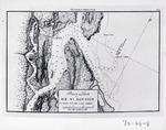 |
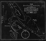
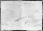
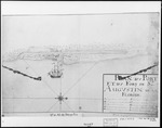
| Barra y Puerto de St. Augustín |
|
| Creator: | |
Anon.
|
| Format: | |
map
|
| Subjects.Display: | |
Coastal chart
|
| Source Institution: | |
University of Florida
|
|
| Barra y Puerto de St. Augustín |
|
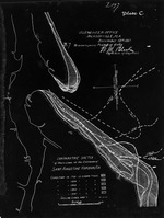 |
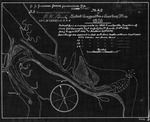
| Comparative Sketch of Shore Lines at the Entrance of Saint Augustine Harbor, Fla. |
|
| Creator: | |
W. M. Black
|
| Format: | |
map
|
| Subjects.Display: | |
Coastal chart
|
| Source Institution: | |
University of Florida
|
|
| Comparative Sketch of Shore Lines at the Entrance of Saint Augustine Harbor, Fla. |
|
|
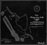 |
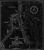
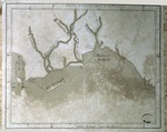
| Map of Matanzas Inlet |
|
| Creator: | |
W. M. Black
|
| Format: | |
map
|
| Subjects.Display: | |
Coastal chart
|
| Source Institution: | |
University of Florida
|
|
| Map of Matanzas Inlet |
|
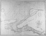 |
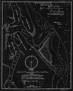
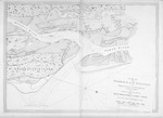
| Map of St. Augustine Harbor |
|
| Creator: | |
W. M. Black
|
| Format: | |
map
|
| Subjects.Display: | |
Coastal chart
|
| Source Institution: | |
University of Florida
|
|
| Map of St. Augustine Harbor |
|
|
 |
| Map of St. Augustine Harbor (1791) |
|
| Creator: | |
W. M. Black
|
| Format: | |
map
|
| Subjects.Display: | |
Coastal chart
|
| Source Institution: | |
University of Florida
|
|
| Map of St. Augustine Harbor (1791) |
|
 |
| Map of St. Augustine Harbor (1826) |
|
| Creator: | |
W. M. Black
|
| Format: | |
map
|
| Subjects.Display: | |
Coastal chart
|
| Source Institution: | |
University of Florida
|
|
| Map of St. Augustine Harbor (1826) |
|
|
 |
| Map of St. Augustine Harbor (1862/3) |
|
| Creator: | |
W. M. Black
|
| Format: | |
map
|
| Subjects.Display: | |
Coastal chart
|
| Source Institution: | |
University of Florida
|
|
| Map of St. Augustine Harbor (1862/3) |
|
 |
| Map of St. Augustine Harbor (1882) |
|
| Creator: | |
W. M. Black
|
| Format: | |
map
|
| Subjects.Display: | |
Coastal chart
|
| Source Institution: | |
University of Florida
|
|
| Map of St. Augustine Harbor (1882) |
|
|
 |
| Map of St. Augustine Harbor (1887) |
|
| Creator: | |
W. M. Black
|
| Format: | |
map
|
| Subjects.Display: | |
Coastal chart
|
| Source Institution: | |
University of Florida
|
|
| Map of St. Augustine Harbor (1887) |
|
 |
| Map of the Harbor and Bar of San Agustin, located in East Florida |
|
| Creator: | |
Anon.
|
| Format: | |
map
|
| Subjects.Display: | |
Coastal chart
|
| Source Institution: | |
University of Florida
|
|
| Map of the Harbor and Bar of San Agustin, located in East Florida |
|
|
 |
| Map of the Harbor Entrance and Harbor of Pensacola |
|
| Creator: | |
Anon.
|
| Format: | |
map
|
| Subjects.Display: | |
Coastal chart
|
| Source Institution: | |
University of Florida
|
|
| Map of the Harbor Entrance and Harbor of Pensacola |
|
 |
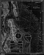
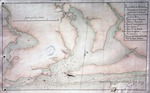
| Mexia Waterway Chart |
|
| Creator: | |
Alberto Mexia
|
| Format: | |
map
|
| Subjects.Display: | |
Coastal chart
|
| Source Institution: | |
University of Florida
|
|
| Mexia Waterway Chart |
|
|
 |
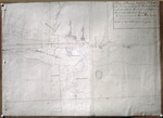
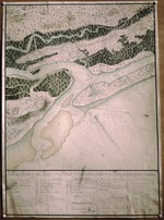
| Part of the Florida Inlet of Matanza |
|
| Creator: | |
Live Todiman
|
| Format: | |
map
|
| Subjects.Display: | |
Coastal chart
|
| Source Institution: | |
University of Florida
|
|
| Part of the Florida Inlet of Matanza |
|
 |
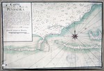
| Pensacola (Bay of Apalache) |
|
| Creator: | |
Anon.
|
| Format: | |
map
|
| Subjects.Display: | |
Coastal chart
|
| Source Institution: | |
University of Florida
|
|
| Pensacola (Bay of Apalache) |
|
|
 |
| Plan du Port de St. Augustin dans la Florida |
|
| Creator: | |
Anon.
Nicolas Bellin ( contributor )
|
| Format: | |
map
|
| Subjects.Display: | |
Coastal chart
|
| Source Institution: | |
University of Florida
|
|
| Plan du Port de St. Augustin dans la Florida |
|
 |
| A Plan of the Harbor of St. Augustin in the Province of Georgia |
|
| Creator: | |
J. F. W. Des Barres
|
| Format: | |
map
|
| Subjects.Display: | |
Coastal chart
|
| Source Institution: | |
University of Florida
|
|
| A Plan of the Harbor of St. Augustin in the Province of Georgia |
|
|
 |
| Plan of the Port and Fort of St. Augustine in Florida |
|
| Creator: | |
Anon.
|
| Format: | |
map
|
| Subjects.Display: | |
Coastal chart
|
| Source Institution: | |
University of Florida
|
|
| Plan of the Port and Fort of St. Augustine in Florida |
|
 |
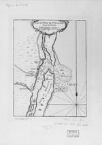
| Plano del Presidio de San Agustinen la Florida Oriental, con la Entrada de sus Barras Y Canos Que lo Circundan |
|
| Creator: | |
Pedro Díaz Berrío
|
| Format: | |
map
|
| Subjects.Display: | |
Coastal chart
|
| Source Institution: | |
University of Florida
|
|
| Plano del Presidio de San Agustinen la Florida Oriental, con la Entrada de sus Barras Y Canos Que lo Circundan |
|
|
![Plano del Puerto de Panzacola [Pensacola]](http://dpanther.fiu.edu/sobek/content/US/AC/H0/01/87/00001/USACH00187_00001_00001thm.jpg) |
| Plano del Puerto de Panzacola [Pensacola] |
|
| Creator: | |
Anon.
|
| Format: | |
map
|
| Subjects.Display: | |
Coastal chart
|
| Source Institution: | |
University of Florida
|
|
| Plano del Puerto de Panzacola [Pensacola] |
|
 |
| Plano del Puerto de Panzacola, 1796 |
|
| Creator: | |
Francisco de Paula Gelabert
[Copyist] Antonio Conesa ( contributor )
|
| Format: | |
map
|
| Subjects.Display: | |
Coastal chart
|
| Source Institution: | |
University of Florida
|
|
| Plano del Puerto de Panzacola, 1796 |
|

