| |
|
 |
| Miami Beach Voting Precinct Maps |
|
| Subjects.Display: | |
Miami Beach (Fla.)
Voting precincts
|
| Source Institution: | |
City of Miami Beach
|
|
| Miami Beach Voting Precinct Maps |
|
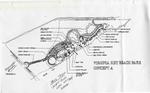 |
| Concept A Plan for Virginia Key Beach Park |
|
| Creator: | |
unknown
|
| Subjects.Display: | |
City planning
Virginia Key Beach Park (Miami, Fla.)
|
| Source Institution: | |
Virginia Key Beach Park Trust
|
|
| Concept A Plan for Virginia Key Beach Park |
|
|
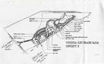 |
| Concept B Plan for Virginia Key Beach Park |
|
| Creator: | |
unknown
|
| Subjects.Display: | |
City planning
Virginia Key Beach Park (Miami, Fla.)
|
| Source Institution: | |
Virginia Key Beach Park Trust
|
|
| Concept B Plan for Virginia Key Beach Park |
|
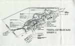 |
| Concept C Plan for Virginia Key Beach Park |
|
| Creator: | |
unknown
|
| Subjects.Display: | |
City planning
Virginia Key Beach Park (Miami, Fla.)
|
| Source Institution: | |
Virginia Key Beach Park Trust
|
|
| Concept C Plan for Virginia Key Beach Park |
|
|
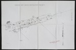 |
| Virginia Beach Flora Restoration Project Map One |
|
| Creator: | |
unknown
|
| Subjects.Display: | |
Virginia Key Beach Park (Miami, Fla.)
Historical geography--Maps
|
| Source Institution: | |
Virginia Key Beach Park Trust
|
|
| Virginia Beach Flora Restoration Project Map One |
|
![[5/13/1884] Township Map of Virginia Key and Key Biscayne](http://dpanther.fiu.edu/sobek/content/FI/VK/04/49/93/00001/FIVK044993thm.jpg) |
| Township Map of Virginia Key and Key Biscayne |
|
| Publication Date: | |
5/13/1884
|
| Creator: | |
Florida Surveyor General's Office
|
| Subjects.Display: | |
Virginia Key Beach Park (Miami, Fla.)
Historical geography--Maps
United States--Historical geography--Maps
|
| Source Institution: | |
Virginia Key Beach Park Trust
|
|
| [5/13/1884] Township Map of Virginia Key and Key Biscayne |
|
|
![[5/18/1918] Map of the Virginia Key Abandoned Military Reservation](http://dpanther.fiu.edu/sobek/content/FI/VK/04/49/92/00001/FIVK044992thm.jpg) |
| Map of the Virginia Key Abandoned Military Reservation |
|
| Publication Date: | |
5/18/1918
|
| Creator: | |
United States Department of the Interior
|
| Subjects.Display: | |
Virginia Key Beach Park (Miami, Fla.)
Historical geography--Maps
United States--Historical geography--Maps
|
| Source Institution: | |
Virginia Key Beach Park Trust
|
|
| [5/18/1918] Map of the Virginia Key Abandoned Military Reservation |
|
![[1925/1929] Maps and documents relating to property in the proposed town of Poinciana](http://dpanther.fiu.edu/sobek/content/RT/EP/00/15/00/00001/file1thm.jpg) |
| Maps and documents relating to property in the proposed town of Poinciana |
|
| Publication Date: | |
1925/1929
|
| Creator: | |
Reclaiming the Everglades
Smith, Loren E
|
| Format: | |
6 items. : ;
|
| Subjects.Display: | |
Real estate development -- Florida -- Everglades
Maps -- Everglades (Fla.)
Lostman's River (Fla.)
Onion Key (Fla.)
Poinciana (Fla.)
|
| Source Institution: | |
Florida International University
|
|
| [1925/1929] Maps and documents relating to property in the proposed town of Poinciana |
|
|
![[1925/1929] Maps and documents relating to property in the proposed town of Poinciana](http://dpanther.fiu.edu/sobek/content/EP/00/15/00/01/00001/file2thm.jpg) |
| Maps and documents relating to property in the proposed town of Poinciana |
|
| Publication Date: | |
1925/1929
|
| Creator: | |
Reclaiming the Everglades
Smith, Loren E
|
| Format: | |
6 items. : ;
|
| Subjects.Display: | |
Real estate development -- Florida -- Everglades
Maps -- Everglades (Fla.)
Lostman's River (Fla.)
Onion Key (Fla.)
Poinciana (Fla.)
|
| Source Institution: | |
Florida International University
|
|
| [1925/1929] Maps and documents relating to property in the proposed town of Poinciana |
|
![[1935] Hurricane Area Map](http://dpanther.fiu.edu/sobek/content/MB/00/00/02/64/00001/295_000thm.jpg) |
| Hurricane Area Map |
|
| Publication Date: | |
1935
|
| Creator: | |
Washington Storage Co., Inc.
|
| Format: | |
1 map : ill ; 34 x 24 cm.
|
| Measurements: | |
34 x 24
|
| Subjects.Display: | |
Hurricanes--Atlantic Coast (U.S.).
Maps--1920-1940.
Hurricanes--Caribbean Area.
Hurricanes--Gulf Coast (U.S.)
|
| Source Institution: | |
City of Miami Beach
|
|
| [1935] Hurricane Area Map |
|
|
![[1929] Map of U.S. National Parks](http://dpanther.fiu.edu/sobek/content/FI/22/09/19/44/00001/FI22091944_00001_Matlack_285_50thm.jpg) |
| Map of U.S. National Parks |
|
| Publication Date: | |
1929
|
| Creator: | |
Matlack, Claude Carson ( Photographer )
|
| Format: | |
8 x 10" Black and white print
|
| Source Institution: | |
HistoryMiami Museum
|
|
| [1929] Map of U.S. National Parks |
|
![[1939?] Map of Greater Miami Florida](http://dpanther.fiu.edu/sobek/content/FI/NM/00/00/17/00001/FINM000017thm.jpg) |
| Map of Greater Miami Florida |
|
| Publication Date: | |
1939?
|
| Creator: | |
Miami Daily News
|
| Publisher.Display: | |
Dolph, Stewart & Miller ( New York )
|
| Format: | |
1 b&w map
|
| Subjects.Display: | |
Miami (Fla.) -- Maps
|
| Source Institution: | |
Greater North Miami Historical Society
|
|
| [1939?] Map of Greater Miami Florida |
|
|
![[1939-07-20] North Miami Beach and Vicinity](http://dpanther.fiu.edu/sobek/content/FI/NM/00/00/19/00001/FINM000019thm.jpg) |
| North Miami Beach and Vicinity |
|
| Publication Date: | |
1939-07-20
|
| Publisher.Display: | |
U.S. Coast and Geodetic Survey
|
| Format: | |
1 b&w map
|
| Subjects.Display: | |
Miami (Fla.) -- Maps
North Miami Beach (Fla.) -- Maps
|
| Source Institution: | |
Greater North Miami Historical Society
|
|
| [1939-07-20] North Miami Beach and Vicinity |
|
![[1949] Opa Locka Quadrangle, Florida](http://dpanther.fiu.edu/sobek/content/FI/NM/00/00/18/00001/FINM000018thm.jpg) |
| Opa Locka Quadrangle, Florida |
|
| Publication Date: | |
1949
|
| Publisher.Display: | |
Geological Survey (U.S.)
|
| Format: | |
1 b&w map
|
| Subjects.Display: | |
Opa-Locka (Fla.) -- Maps
|
| Source Institution: | |
Greater North Miami Historical Society
|
|
| [1949] Opa Locka Quadrangle, Florida |
|
|
![[1950-1959] 1950s Miami Beach Voting Precincts Map](http://dpanther.fiu.edu/sobek/content/MB/00/00/09/67/00003/967_3_1_000thm.jpg) |
| 1950s Miami Beach Voting Precincts Map |
|
| Publication Date: | |
1950-1959
|
| Subjects.Display: | |
Miami Beach (Fla.)
Voting precincts
|
| Source Institution: | |
City of Miami Beach
|
|
| [1950-1959] 1950s Miami Beach Voting Precincts Map |
|
![[1953] 1953 Historic Plan for Virginia Key Beach Park](http://dpanther.fiu.edu/sobek/content/FI/VK/04/49/77/00001/FIVK044977thm.jpg) |
| 1953 Historic Plan for Virginia Key Beach Park |
|
| Publication Date: | |
1953
|
| Creator: | |
unknown
|
| Subjects.Display: | |
Virginia Key Beach Park (Miami, Fla.)
Historical geography--Maps
United States--Historical geography--Maps
|
| Source Institution: | |
Virginia Key Beach Park Trust
|
|
| [1953] 1953 Historic Plan for Virginia Key Beach Park |
|
|
![[1953] 1954 Historic Plan for Virginia Key Beach Park](http://dpanther.fiu.edu/sobek/content/FI/VK/04/49/78/00001/FIVK044978thm.jpg) |
| 1954 Historic Plan for Virginia Key Beach Park |
|
| Publication Date: | |
1953
|
| Creator: | |
unknown
|
| Subjects.Display: | |
Virginia Key Beach Park (Miami, Fla.)
Historical geography--Maps
United States--Historical geography--Maps
|
| Source Institution: | |
Virginia Key Beach Park Trust
|
|
| [1953] 1954 Historic Plan for Virginia Key Beach Park |
|
![[1953] Colorized Wallace, Roberts, and Todd LLC. Virginia Key Beach Park 1953 Historic Plan](http://dpanther.fiu.edu/sobek/content/FI/VK/04/49/81/00001/FIVK044981thm.jpg) |
| Colorized Wallace, Roberts, and Todd LLC. Virginia Key Beach Park 1953 Historic Plan |
|
| Publication Date: | |
1953
|
| Creator: | |
Wallace, Roberts, and Todd LLC.
|
| Subjects.Display: | |
Virginia Key Beach Park (Miami, Fla.)
Historical geography--Maps
United States--Historical geography--Maps
|
| Source Institution: | |
Virginia Key Beach Park Trust
|
|
| [1953] Colorized Wallace, Roberts, and Todd LLC. Virginia Key Beach Park 1953 Historic Plan |
|
|
![[1956-03-16] Larson's map of Greater Miami](http://dpanther.fiu.edu/sobek/content/FI/NM/00/03/33/00001/FINM000333thm.jpg) |
| Larson's map of Greater Miami |
|
| Publication Date: | |
1956-03-16
|
| Publisher.Display: | |
Larson's Enterprise ( Coral Gables, Fla. )
|
| Format: | |
1 b&w negative; 4x5 inches
|
| Subjects.Display: | |
Miami (Fla.) -- Maps
|
| Source Institution: | |
Greater North Miami Historical Society
|
|
| [1956-03-16] Larson's map of Greater Miami |
|
![[1958-07-28] 1958 Miami Beach Voting Precinct Maps](http://dpanther.fiu.edu/sobek/content/MB/00/00/09/67/00005/967_5_1_000thm.jpg) |
| 1958 Miami Beach Voting Precinct Maps |
|
| Publication Date: | |
1958-07-28
|
| Subjects.Display: | |
Miami Beach (Fla.)
Voting precincts
|
| Source Institution: | |
City of Miami Beach
|
|
| [1958-07-28] 1958 Miami Beach Voting Precinct Maps |
|

