| |
|
 |
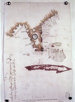
| Map of the Gulf of Mexico + the West Indies |
|
| Creator: | |
Pietro Martire d'Anghiera
|
| Format: | |
map
|
| Subjects.Display: | |
Map
|
| Source Institution: | |
University of Florida
|
|
| Map of the Gulf of Mexico + the West Indies |
|
|
| Tabula Terre Nove |
|
| Creator: | |
Claudius Ptolemaeus
|
| Format: | |
map
|
| Subjects.Display: | |
Map
|
| Source Institution: | |
University of Florida
|
|
| Tabula Terre Nove |
|
|
|
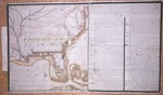
| Traza de las Costas de Tierra-Firme y de las Tierras-Nuevas |
|
| Creator: | |
Alonzo Alvarez de Pinedo
|
| Format: | |
map
|
| Subjects.Display: | |
Map
|
| Source Institution: | |
University of Florida
|
|
| Traza de las Costas de Tierra-Firme y de las Tierras-Nuevas |
|
 |
| Planta de la Costa de la Florida |
|
| Creator: | |
Anon.
|
| Format: | |
map
|
| Subjects.Display: | |
Map
|
| Source Institution: | |
University of Florida
|
|
| Planta de la Costa de la Florida |
|
|
|
| Peruviae…, La Florida…, Nove Hisp…, |
|
| Creator: | |
Didaco Mendezio
|
| Format: | |
map
|
| Subjects.Display: | |
Map
|
| Source Institution: | |
University of Florida
|
|
| Peruviae…, La Florida…, Nove Hisp…, |
|
 |
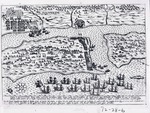
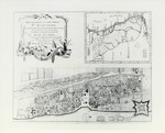
| Map of Town, Fort + Channel of San Augustin |
|
| Creator: | |
Anon.
|
| Format: | |
map
|
| Subjects.Display: | |
Map
|
| Source Institution: | |
University of Florida
|
|
| Map of Town, Fort + Channel of San Augustin |
|
|
 |
| La Citte Sainct Augustin toute Bastie de Maisons |
|
| Creator: | |
Anon.
|
| Format: | |
map
|
| Subjects.Display: | |
Map
|
| Source Institution: | |
University of Florida
|
|
| La Citte Sainct Augustin toute Bastie de Maisons |
|
|
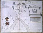
| Descripcion del Puerte de Apalache |
|
| Creator: | |
Pablo de Hita y Salazar
|
| Format: | |
map
|
| Subjects.Display: | |
Map
|
| Source Institution: | |
University of Florida
|
|
| Descripcion del Puerte de Apalache |
|
|
 |
| Castillo and poximities of Pilijiriba, 1703 |
|
| Creator: | |
Anon.
|
| Format: | |
map
|
| Subjects.Display: | |
Map
|
| Source Institution: | |
University of Florida
|
|
| Castillo and poximities of Pilijiriba, 1703 |
|
 |
| Cove and River of Apalache and road from San Luis to San Marcos |
|
| Creator: | |
Anon.
|
| Format: | |
map
|
| Subjects.Display: | |
Map
|
| Source Institution: | |
University of Florida
|
|
| Cove and River of Apalache and road from San Luis to San Marcos |
|
|
|
| Accurata delineatio celeberrimae Regionis LUDOVICIANÆ vel Gallice LOUISIANE…(North America) |
|
| Creator: | |
Matthew Seutter
|
| Format: | |
map
|
| Subjects.Display: | |
Map
|
| Source Institution: | |
University of Florida
|
|
| Accurata delineatio celeberrimae Regionis LUDOVICIANÆ vel Gallice LOUISIANE…(North America) |
|
 |
| Descripcion Geographica de la parte que lost Espanoles |
|
| Creator: | |
Anon.
|
| Format: | |
map
|
| Subjects.Display: | |
Map
|
| Source Institution: | |
University of Florida
|
|
| Descripcion Geographica de la parte que lost Espanoles |
|
|
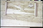 |
| A Survey of the Coast from Fort William near St. Ivans River to Mosquito River |
|
| Creator: | |
Justly Watson
|
| Format: | |
map
|
| Subjects.Display: | |
Map
|
| Source Institution: | |
University of Florida
|
|
| A Survey of the Coast from Fort William near St. Ivans River to Mosquito River |
|
|
| Carte de la Louisiane et particulierement de Fleuve Mississippi |
|
| Creator: | |
Broutin et. al.
|
| Format: | |
map
|
| Subjects.Display: | |
Map
|
| Source Institution: | |
University of Florida
|
|
| Carte de la Louisiane et particulierement de Fleuve Mississippi |
|
|
|
| The British Governments in Nort America |
|
| Creator: | |
J. Gibson
|
| Format: | |
map
|
| Subjects.Display: | |
Map
|
| Source Institution: | |
University of Florida
|
|
| The British Governments in Nort America |
|
 |
| Descripcion Geographica, de la parte que los Espanoles poseen acualmente en el continente de la Florida |
|
| Creator: | |
Fernando Martinez
|
| Format: | |
map
|
| Subjects.Display: | |
Map
|
| Source Institution: | |
University of Florida
|
|
| Descripcion Geographica, de la parte que los Espanoles poseen acualmente en el continente de la Florida |
|
|
|
| Map Furnished by Spain to England , 1756 |
|
| Creator: | |
Anon.
|
| Format: | |
map
|
| Subjects.Display: | |
Map
|
| Source Institution: | |
University of Florida
|
|
| Map Furnished by Spain to England , 1756 |
|
|
| New Map of East Florida |
|
| Creator: | |
William Stork
P. Andrews ( contributor )
|
| Format: | |
map
|
| Subjects.Display: | |
Map
|
| Source Institution: | |
University of Florida
|
|
| New Map of East Florida |
|
|
 |
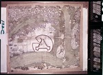
| St. Augustine and its Environs, 1768 |
|
| Creator: | |
Juan Joseph Elixio de la Puente
|
| Format: | |
map
|
| Subjects.Display: | |
Map
|
| Source Institution: | |
University of Florida
|
|
| St. Augustine and its Environs, 1768 |
|
|
| Map of the General Surveys of East Florida |
|
| Creator: | |
Wm. Gerard De Brahm
|
| Format: | |
map
|
| Subjects.Display: | |
Map
|
| Source Institution: | |
University of Florida
|
|
| Map of the General Surveys of East Florida |
|

