| |
|
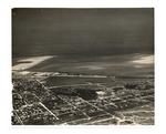 |
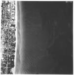
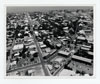
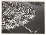
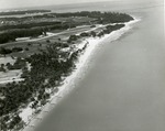
| An aerial photo of Key West from North Flagler across Fleming Key |
|
| Publication Date: | |
1942
|
| Creator: | |
Monroe County Public Library System
May Hill Russell Library -- History Dept
Ida Woodward Barron Collection
|
| Format: | |
1 photograph : b&w ; 8 x 10 in.
|
| Subjects.Display: | |
Monroe -- 12087
Aerial photographs -- Monroe County (Fla.)
Buildings, structures, etc -- Aerial photographs -- Key West (Fla.)
Aerial photographs -- Key West (Fla.)
Streets -- Aerial photographs -- Florida -- Key West
Bays -- Aerial photographs -- Florida -- Key West
Aerial photographs -- Naval station Key West (Fla.)
|
| Source Institution: | |
Florida International University
|
|
| An aerial photo of Key West from North Flagler across Fleming Key |
|
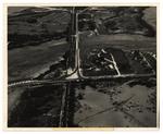 |
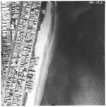
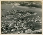
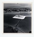
| An aerial photo of the Naval Hosptial site, golf course, and Highway One |
|
| Publication Date: | |
1941
|
| Creator: | |
Monroe County Public Library System
May Hill Russell Library -- History Dept
United States -- Navy
|
| Format: | |
1 photograph : b&w ; 8 x 10 in.
|
| Subjects.Display: | |
Monroe -- 12087
Aerial photographs -- Monroe County (Fla.)
Aerial photographs -- Key West (Fla.)
Roads -- Aerial photographs -- Florida -- Key West
Hospitals, Military -- Aerial photographs -- Florida -- Key West
Golf courses -- Aerial photographs -- Florida -- Key West
|
| Source Institution: | |
Florida International University
|
|
| An aerial photo of the Naval Hosptial site, golf course, and Highway One |
|
|
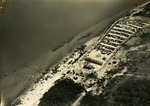 |
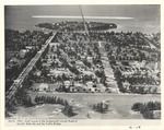
| Aerial photo of Virginia Beach Park |
|
| Creator: | |
Richard B. Hoit ( Photographer )
|
| Subjects.Display: | |
Parking lots
aerial photographs
Virginia Key Beach Park (Miami, Fla.)
African Americans--Segregation
Beachgoers
|
| Source Institution: | |
Virginia Key Beach Park Trust
|
|
| Aerial photo of Virginia Beach Park |
|
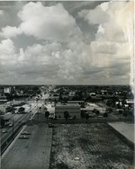 |
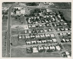
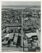
| Aerial Photograph of East Oakland Park Blvd |
|
| Publication Date: | |
1974
|
| Creator: | |
Woodward, David ( Photographer )
|
| Format: | |
10 in x 8 in
|
| Subjects.Display: | |
Streets
Florida--Oakland Park (Broward County)
|
| Source Institution: | |
Ethel M. Gordon Oakland Park Library
|
|
| Aerial Photograph of East Oakland Park Blvd |
|
|
 |
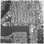
| Aerial survey photographs of Miami Beach along coast and A1A Collins Ave |
|
| Publication Date: | |
1958
|
| Publisher.Display: | |
Rader & Associates Engineers & Architects ( Miami, Fla. )
|
| Format: | |
7 photographs : ill. ; 23 x 23 cm.
|
| Measurements: | |
23 x 23
|
| Subjects.Display: | |
Miami Beach (Fla.)--Aerial views.
Miami Beach (Fla.)--Aerial photographs.
Collins Avenue (Miami Beach, Fla.)--1950-1960.
Houses--1950-1960.
Beaches--1950-1960.
Indian Creek Drive (Miami Beach, Fla.)--1950-1960.
|
| Source Institution: | |
City of Miami Beach
|
|
| Aerial survey photographs of Miami Beach along coast and A1A Collins Ave |
|
 |
| Aerial survey photographs of Miami Beach between Lummus Park to Government Cut. |
|
| Publisher.Display: | |
Rader & Associates, ( Miami, Fla. : )
|
| Format: | |
5 photographs : ill. ; 23 x 23 cm.
|
| Measurements: | |
23 x 23
|
| Subjects.Display: | |
Miami Beach (Fla.)--Buildings, structures, etc.--Pictorial works.
Miami Beach (Fla.)--Aerial views.
Miami Beach (Fla.)--Aerial photographs.
Collins Avenue (Miami Beach, Fla.)--1950-1960.
Houses--1950-1960.
Parks--1950-1960.
Washington Avenue (Miami Beach, Fla.)--1950-1960.
Lincoln Road (Miami Beach, Fla.)--1950-1960.
Ocean Drive (Miami Beach, Fla.)--1950-1960.
Streets--1950-1970.
|
| Source Institution: | |
City of Miami Beach
|
| Donor: | |
Ares, Aristotle.
|
|
| Aerial survey photographs of Miami Beach between Lummus Park to Government Cut. |
|
|
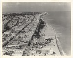 |
| Aerial view looking north from 4th Street, 1964 |
|
| Publication Date: | |
1964
|
| Creator: | |
Hansen, Chris ( Photographer )
|
| Publisher.Display: | |
The City of Miami Beach News Bureau, ( Miami Beach, Fla. : )
|
| Format: | |
1 photograph: ill . ; 21 x 26 cm
|
| Measurements: | |
21 x 26
|
| Subjects.Display: | |
Miami Beach (Fla.)--Pictorial works.
Miami Beach (Fla.)--Aerial views.
Art deco (Architecture)--United States--Florida--Miami Beach--Pictorial works.
Beaches--United States--Florida--Miami Beach--1960-1970.
Lummus Park (Miami Beach, Fla.)
Ocean Drive (Miami Beach, Fla.)--1960-1970.
Fourth Street (Miami Beach, Fla.)--1960-1970.
|
| Source Institution: | |
City of Miami Beach
|
|
| Aerial view looking north from 4th Street, 1964 |
|
 |
| Aerial view looking north from Government Cut showing Greyhound Racetrack in South Shore, 1964 |
|
| Publication Date: | |
1964
|
| Creator: | |
Hansen, Chris ( Photographer )
|
| Publisher.Display: | |
City of Miami Beach News Bureau, ( Miami Beach, Fla. : )
|
| Format: | |
1 photograph : ill. ; 21 x 26 cm.
|
| Subjects.Display: | |
Miami Beach (Fla.)--Pictorial works.
Miami Beach (Fla.)--Buildings, structures, etc.--Pictorial works.
Miami Beach (Fla.)--Aerial photographs.
Beaches--United States--Florida--Miami Beach--1960-1970.
Lummus Park (Miami Beach, Fla.)
Channels--1960-1970.
Racetracks--1960-1970.
Jetties--1960-1970
Government Cut (Miami Beach (Fla.)
|
| Source Institution: | |
City of Miami Beach
|
|
| Aerial view looking north from Government Cut showing Greyhound Racetrack in South Shore, 1964 |
|
|
 |
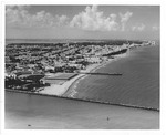
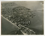
| Aerial view looking south on Duval Street |
|
| Publication Date: | |
1970
|
| Creator: | |
Monroe County Public Library System
May Hill Russell Library -- History Dept
United States -- Navy
|
| Format: | |
1 photograph : b&w ; 8 x 10 in.
|
| Subjects.Display: | |
Monroe -- 12087
Aerial photographs -- Monroe County (Fla.)
Buildings, structures, etc -- Aerial photographs -- Key West (Fla.)
Aerial photographs -- Key West (Fla.)
|
| Source Institution: | |
Florida International University
|
|
| Aerial view looking south on Duval Street |
|
 |
| Aerial view looking west at Surfside, Bal Harbour, Bay Harbor, and North Miami |
|
| Publication Date: | |
1952-04-12
|
| Creator: | |
McKay Aerial Photos
|
| Format: | |
1 b&w photograph ; 8 x 10 inches
|
| Subjects.Display: | |
North Miami (Fla.) -- Aerial views
|
| Source Institution: | |
Greater North Miami Historical Society
|
|
| Aerial view looking west at Surfside, Bal Harbour, Bay Harbor, and North Miami |
|
|
 |
| Aerial view looking west from Meridian Avenue and Lincoln Road. |
|
| Publication Date: | |
1923
|
| Format: | |
1 photograph : ill. ; 19 x 25 cm.
|
| Measurements: | |
19 x 25
|
| Subjects.Display: | |
Miami Beach (Fla.)--Aerial photographs.
Islands--1920-1930.
Construction--1920-1930.
Lincoln Road (Miami Beach, Fla.)--1920-1930.
Golf courses--1920-1930.
|
| Source Institution: | |
City of Miami Beach
|
|
| Aerial view looking west from Meridian Avenue and Lincoln Road. |
|
 |
| Aerial view of 125th. Street to Florida East Coast railway in 1958 |
|
| Publication Date: | |
1958
|
| Format: | |
1 b&w photograph ; 8 x 10 inches
|
| Subjects.Display: | |
North Miami (Fla.) -- Aerial views
|
| Source Institution: | |
Greater North Miami Historical Society
|
|
| Aerial view of 125th. Street to Florida East Coast railway in 1958 |
|
|
 |
| Aerial view of 70th Street Causeway and Bay Drive |
|
| Publication Date: | |
1956
|
| Creator: | |
City of Miami Beach
|
| Subjects.Display: | |
Miami Beach (Fla.)--Pictorial works.
Public libraries
|
| Source Institution: | |
City of Miami Beach
|
|
Aerial view of 70th Street Causeway and Bay Drive
( 2 volumes ) |
|
 |
| Aerial view of Army tower |
|
| Publication Date: | |
1945
|
| Creator: | |
Monroe County Public Library System
May Hill Russell Library -- History Dept
Ida Woodward Barron Collection
|
| Format: | |
1 photograph : b&w ; 7 x 7 in.
|
| Subjects.Display: | |
Monroe -- 12087
Aerial photographs -- Monroe County (Fla.)
Aerial photographs -- Key West (Fla.)
Shorelines -- Aerial Photographs -- Key West (Fla.)
Water towers -- Aerial photographs -- Florida -- Key West
|
| Source Institution: | |
Florida International University
|
|
| Aerial view of Army tower |
|
|
 |
| Aerial view of Bal Harbour, Bay Harbor Islands and Indian Creek in Florida |
|
| Publication Date: | |
1957-03-14
|
| Creator: | |
Tierney and Killingswoth
|
| Format: | |
1 b&w Photograph; 8 x 10 inches
|
| Subjects.Display: | |
Bay Harbor Islands (Fla.) -- Aerial views
Bal Harbour (Fla.) -- Aerial views
Indian Creek Village (Fla.) -- Aerial views
|
| Source Institution: | |
Greater North Miami Historical Society
|
|
| Aerial view of Bal Harbour, Bay Harbor Islands and Indian Creek in Florida |
|
 |
| Aerial view of Bal Harbour, Florida |
|
| Publication Date: | |
1961-12-06
|
| Creator: | |
Tierney and Killingswoth
|
| Format: | |
1 b&w Photograph; 8 x 10 inches
|
| Subjects.Display: | |
Bal Harbour (Fla.) -- Aerial views
|
| Source Institution: | |
Greater North Miami Historical Society
|
|
| Aerial view of Bal Harbour, Florida |
|
|
 |
| Aerial view of beach area |
|
| Subjects.Display: | |
Palms
aerial photographs
Virginia Key Beach Park (Miami, Fla.)
African Americans--Segregation
|
| Source Institution: | |
Virginia Key Beach Park Trust
|
|
| Aerial view of beach area |
|
 |
| Aerial view of Biscaya Island |
|
| Publication Date: | |
1958
|
| Publisher.Display: | |
Rader & Associates Engineers & Architects
|
| Format: | |
Series includes 22 photographs : ill. ; 23 x 23 cm.
|
| Subjects.Display: | |
Miami Beach (Fla.)--Aerial views.
|
| Source Institution: | |
City of Miami Beach
|
|
Aerial view of Biscaya Island
( 22 volumes ) |
|
|
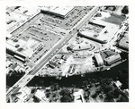 |
| Aerial view of Biscayne Shopping Plaza, NE 79 St. and Biscayne Blvd. |
|
| Publication Date: | |
1950-1959
|
| Format: | |
1 b&w photograph ; 8 x 10 inches
|
| Subjects.Display: | |
Roads -- Florida -- North Miami
Miami (Fla.) -- Aerial views
|
| Source Institution: | |
Greater North Miami Historical Society
|
|
| Aerial view of Biscayne Shopping Plaza, NE 79 St. and Biscayne Blvd. |
|
 |
| An aerial view of Boca Chica |
|
| Publication Date: | |
1970
|
| Creator: | |
Monroe County Public Library System
May Hill Russell Library -- History Dept
Ida Woodward Barron Collection
|
| Format: | |
1 photograph : color ; 11 x 13 in.
|
| Subjects.Display: | |
Monroe -- 12087
Aerial photographs -- Monroe County (Fla.)
Airplanes -- Aerial photographs -- Florida -- Monroe County
|
| Source Institution: | |
Florida International University
|
|
| An aerial view of Boca Chica |
|

