| |
|
 |
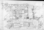
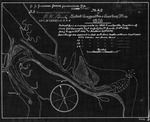
| Plan of St. Augustin Inlet and Town, with it's Environs |
|
| Creator: | |
Wm. Gerard De Brahm
|
| Format: | |
map
|
| Subjects.Display: | |
Plan
|
| Source Institution: | |
University of Florida
|
|
| Plan of St. Augustin Inlet and Town, with it's Environs |
|
|
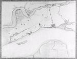
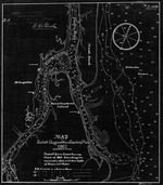
| Plano de la Poblacion de Pansacola |
|
| Creator: | |
Anon.
|
| Format: | |
map
|
| Subjects.Display: | |
Plan
|
| Source Institution: | |
University of Florida
|
|
| Plano de la Poblacion de Pansacola |
|
|
 |
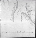
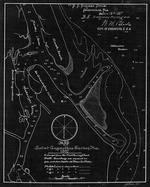
| Rough Draft of the finca in Escambia |
|
| Creator: | |
Elias Durnford
|
| Format: | |
map
|
| Source Institution: | |
University of Florida
|
|
| Rough Draft of the finca in Escambia |
|
 |
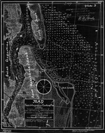
| St. Augustine and its Environs, 1782 |
|
| Creator: | |
Anon.
|
| Format: | |
map
|
| Subjects.Display: | |
Map
|
| Source Institution: | |
University of Florida
|
|
| St. Augustine and its Environs, 1782 |
|
|
 |
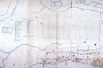
| A Plan of St. Augustine in East Floreda from a survey in 1783 |
|
| Creator: | |
John Purcell
|
| Format: | |
map
|
| Subjects.Display: | |
Plan
|
| Source Institution: | |
University of Florida
|
|
| A Plan of St. Augustine in East Floreda from a survey in 1783 |
|
|
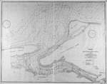
| St. Augustine Harbor (Part of Canal Plan) |
|
| Creator: | |
Lt. Col. P. H. Perrault
[Drawn by] Lt. Jefferson Vail ( contributor )
|
| Format: | |
map
|
| Subjects.Display: | |
Coastal chart
|
| Source Institution: | |
University of Florida
|
|
| St. Augustine Harbor (Part of Canal Plan) |
|
|
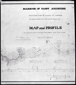 |
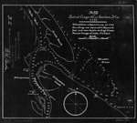
| Harbour of Saint Augustine |
|
| Creator: | |
Lt. Col. P. H. Perrault
[Drawn by] Lt. Jefferson Vail ( contributor )
|
| Format: | |
map
|
| Subjects.Display: | |
Survey and Profile
|
| Source Institution: | |
University of Florida
|
|
| Harbour of Saint Augustine |
|
 |
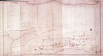
| Plan of City of St. Augustine copied from a drawing made in 1831 |
|
| Creator: | |
Anon.
|
| Format: | |
map
|
| Subjects.Display: | |
Map
|
| Source Institution: | |
University of Florida
|
|
| Plan of City of St. Augustine copied from a drawing made in 1831 |
|
|
 |
| Copy of a Plan of the City of St. Augustine, Flora with some additions for the year 1833 |
|
| Creator: | |
Anon.
|
| Format: | |
map
|
| Subjects.Display: | |
Plan
|
| Source Institution: | |
University of Florida
|
|
| Copy of a Plan of the City of St. Augustine, Flora with some additions for the year 1833 |
|
|
| North America XIV Florida |
|
| Creator: | |
Tanner
|
| Format: | |
map
|
| Subjects.Display: | |
Map
|
| Source Institution: | |
University of Florida
|
|
| North America XIV Florida |
|
|
|
| Plan of the City of St. Augustine |
|
| Creator: | |
Benjamin and J. B. Clements
|
| Format: | |
map
|
| Subjects.Display: | |
Plan
|
| Source Institution: | |
University of Florida
|
|
| Plan of the City of St. Augustine |
|
 |
| St. Johns River, Six Mile Creek Blowup (Part of Canal Plan) |
|
| Creator: | |
Lt. Col. P. H. Perrault
[Drawn by] Lt. Jefferson Vail ( contributor )
|
| Format: | |
map
|
| Subjects.Display: | |
Survey and Profile
|
| Source Institution: | |
University of Florida
|
|
| St. Johns River, Six Mile Creek Blowup (Part of Canal Plan) |
|
|
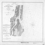 |
| Preliminary Chart of St. Augustine Harbor, ed. #2 |
|
| Creator: | |
A. D. Bache
|
| Format: | |
map
|
| Subjects.Display: | |
Coastal chart
|
| Source Institution: | |
University of Florida
|
|
| Preliminary Chart of St. Augustine Harbor, ed. #2 |
|
 |
| Map of the City of St. Augustine, East Florida, 1884 |
|
| Creator: | |
Anon.
|
| Format: | |
map
|
| Subjects.Display: | |
Survey
|
| Source Institution: | |
University of Florida
|
|
| Map of the City of St. Augustine, East Florida, 1884 |
|
|
 |
| Map of St. Augustine Harbor |
|
| Creator: | |
W. M. Black
|
| Format: | |
map
|
| Subjects.Display: | |
Coastal chart
|
| Source Institution: | |
University of Florida
|
|
| Map of St. Augustine Harbor |
|
 |
| Map of St. Augustine Harbor (1791) |
|
| Creator: | |
W. M. Black
|
| Format: | |
map
|
| Subjects.Display: | |
Coastal chart
|
| Source Institution: | |
University of Florida
|
|
| Map of St. Augustine Harbor (1791) |
|
|
 |
| Map of St. Augustine Harbor (1826) |
|
| Creator: | |
W. M. Black
|
| Format: | |
map
|
| Subjects.Display: | |
Coastal chart
|
| Source Institution: | |
University of Florida
|
|
| Map of St. Augustine Harbor (1826) |
|
 |
| Map of St. Augustine Harbor (1862/3) |
|
| Creator: | |
W. M. Black
|
| Format: | |
map
|
| Subjects.Display: | |
Coastal chart
|
| Source Institution: | |
University of Florida
|
|
| Map of St. Augustine Harbor (1862/3) |
|
|
 |
| Map of St. Augustine Harbor (1882) |
|
| Creator: | |
W. M. Black
|
| Format: | |
map
|
| Subjects.Display: | |
Coastal chart
|
| Source Institution: | |
University of Florida
|
|
| Map of St. Augustine Harbor (1882) |
|
 |
| Map of St. Augustine Harbor (1887) |
|
| Creator: | |
W. M. Black
|
| Format: | |
map
|
| Subjects.Display: | |
Coastal chart
|
| Source Institution: | |
University of Florida
|
|
| Map of St. Augustine Harbor (1887) |
|

