| |
|
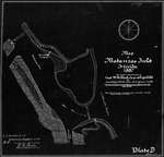 |
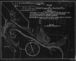
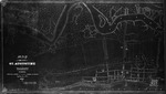
| Map of Matanzas Inlet |
|
| Creator: | |
W. M. Black
|
| Format: | |
map
|
| Subjects.Display: | |
Coastal chart
|
| Source Institution: | |
University of Florida
|
|
| Map of Matanzas Inlet |
|
 |
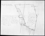
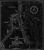
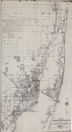
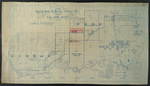
| Map of Miami, Dade Co. Fla. |
|
| Publication Date: | |
1896-06-09
|
| Creator: | |
Knowlton, A. L. ( Surveyor )
Frederick, J. S. ( Surveyor )
Ord, L. R. ( Surveyor )
|
| Source Institution: | |
Florida International University
|
| Donor: | |
Petsoules, Carmen
|
|
| Map of Miami, Dade Co. Fla. |
|
|
 |
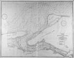
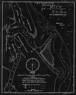
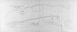
| Map of site of Fort Marion |
|
| Creator: | |
Anon.
|
| Format: | |
map
|
| Subjects.Display: | |
Survey
|
| Source Institution: | |
University of Florida
|
|
| Map of site of Fort Marion |
|
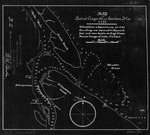
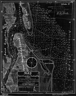
![Map of South Florida. 19--]](http://dpanther.fiu.edu/sobek/content/MW/00/99/00/02/00001/001a_thm.jpg) |
| Map of South Florida. 19--] |
|
| Creator: | |
Moore-Willson, Minnie, b. 1863. ( Contributor )
|
| Format: | |
1 map.
|
| Subjects.Display: | |
Everglades (Fla.)--Maps.
|
| Source Institution: | |
Florida International University
|
|
| Map of South Florida. 19--] |
|
|
 |
| Map of St. Augustine Harbor |
|
| Creator: | |
W. M. Black
|
| Format: | |
map
|
| Subjects.Display: | |
Coastal chart
|
| Source Institution: | |
University of Florida
|
|
| Map of St. Augustine Harbor |
|
 |
| Map of St. Augustine Harbor (1791) |
|
| Creator: | |
W. M. Black
|
| Format: | |
map
|
| Subjects.Display: | |
Coastal chart
|
| Source Institution: | |
University of Florida
|
|
| Map of St. Augustine Harbor (1791) |
|
|
 |
| Map of St. Augustine Harbor (1826) |
|
| Creator: | |
W. M. Black
|
| Format: | |
map
|
| Subjects.Display: | |
Coastal chart
|
| Source Institution: | |
University of Florida
|
|
| Map of St. Augustine Harbor (1826) |
|
 |
| Map of St. Augustine Harbor (1862/3) |
|
| Creator: | |
W. M. Black
|
| Format: | |
map
|
| Subjects.Display: | |
Coastal chart
|
| Source Institution: | |
University of Florida
|
|
| Map of St. Augustine Harbor (1862/3) |
|
|
 |
| Map of St. Augustine Harbor (1882) |
|
| Creator: | |
W. M. Black
|
| Format: | |
map
|
| Subjects.Display: | |
Coastal chart
|
| Source Institution: | |
University of Florida
|
|
| Map of St. Augustine Harbor (1882) |
|
 |
| Map of St. Augustine Harbor (1887) |
|
| Creator: | |
W. M. Black
|
| Format: | |
map
|
| Subjects.Display: | |
Coastal chart
|
| Source Institution: | |
University of Florida
|
|
| Map of St. Augustine Harbor (1887) |
|
|
 |
| Map of the City of St. Augustine & Vicinity, 1863 |
|
| Creator: | |
Col. J. R. Hawley
|
| Format: | |
map
|
| Subjects.Display: | |
Map
|
| Source Institution: | |
University of Florida
|
|
| Map of the City of St. Augustine & Vicinity, 1863 |
|
 |
| Map of the City of St. Augustine, East Florida, 1884 |
|
| Creator: | |
Anon.
|
| Format: | |
map
|
| Subjects.Display: | |
Survey
|
| Source Institution: | |
University of Florida
|
|
| Map of the City of St. Augustine, East Florida, 1884 |
|
|
 |
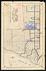
| Map of the metropolitan district of Dade County, Florida complied from records of government and private surveys |
|
| Publication Date: | |
1921-10-01
|
| Creator: | |
Gorris, M. B.
|
| Publisher.Display: | |
P. L. Watson Civil Engineers
|
| Source Institution: | |
Florida International University
|
| Donor: | |
Petsoules, Carmen
|
|
| Map of the metropolitan district of Dade County, Florida complied from records of government and private surveys |
|
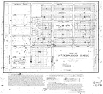 |
| Map of Wynwood Park |
|
| Publication Date: | |
1917-01
|
| Creator: | |
Llewellyn Eng. Co.
|
| Format: | |
map
|
| Subjects.Display: | |
Real property--Maps
Wynwood (Miami, Fla.)
|
| Source Institution: | |
Florida International University
|
|
| Map of Wynwood Park |
|
|
 |
| Map showing completed canals in Southern Drainage District to June 1, 1934. |
|
| Publication Date: | |
1934
|
| Creator: | |
Biscayne Engineering Company. ( Contributor )
Model Land Company. ( Contributor )
|
| Publisher.Display: | |
Biscayne Engineering Company, ( Miami, Fla. : )
|
| Subjects.Display: | |
Everglades (Fla.)--Maps.
Southern Drainage District (Fla.)
Highleyman, Locke T.,--b. 1870.
Canals--Florida--Everglades.
|
| Source Institution: | |
Florida International University
|
|
| Map showing completed canals in Southern Drainage District to June 1, 1934. |
|
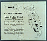 |
| Map showing location of game breeding grounds. |
|
| Publication Date: | |
1927
|
| Creator: | |
Moore-Willson, Minnie, b. 1863. ( Contributor )
Royall, J. B.
|
| Publisher.Display: | |
T. J. Appleyard.
|
| Format: | |
1 map.
|
| Subjects.Display: | |
Everglades (Fla.)--Maps.
|
| Source Institution: | |
Florida International University
|
|
| Map showing location of game breeding grounds. |
|
|
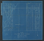 |
| Map showing results of examination of the Tamiami Trail lands in Dade County, Florida, to accompany report dated March 23, 1917. |
|
| Publication Date: | |
1917
|
| Creator: | |
King, John W.
Jaudon, James Franklin, 1873-1938. ( contributor )
|
| Publisher.Display: | |
King ( Miami )
|
| Format: | |
1 map : blueprint.
|
| Subjects.Display: | |
Everglades (Fla.)--Maps.
Tamiami Trail (Fla.)--Maps.
|
| Source Institution: | |
Florida International University
|
|
| Map showing results of examination of the Tamiami Trail lands in Dade County, Florida, to accompany report dated March 23, 1917. |
|
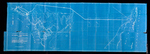 |
| Map showing results of exploration and examinations in Lee, Monroe and Dade Counties, Florida. |
|
| Publication Date: | |
1917
|
| Creator: | |
King, John W.
Jaudon, James Franklin, 1873-1938. ( contributor )
|
| Publisher.Display: | |
Miami: King
|
| Format: | |
1 map : blueprint.
|
| Subjects.Display: | |
Everglades (Fla.)--Maps.
Ten Thousand Islands (Fla.)--Maps.
Biscayne Bay (Fla.)--Maps.
|
| Source Institution: | |
Florida International University
|
|
| Map showing results of exploration and examinations in Lee, Monroe and Dade Counties, Florida. |
|
|
 |
| Map showing special road and bridges, Cape Sable District, Monroe County, 1920 |
|
| Publication Date: | |
1920
|
| Creator: | |
Livingston, A. R.
|
| Format: | |
1 map.
|
| Subjects.Display: | |
Monroe--12087--ceeus
Ingraham Highway (Fla.)
Everglades (Fla.)--Maps.
Jennings Tract (Fla.)
Monroe County (Fla.)--Maps.
Sable, Cape (Fla.)--Maps.
|
| Source Institution: | |
Florida International University
|
|
| Map showing special road and bridges, Cape Sable District, Monroe County, 1920 |
|
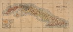 |
| Mapa de la Isla de Cuba. Formado con datos tomados de los mejores planos y cartas geográficas. |
|
| Publication Date: | |
1895
|
| Creator: | |
Arbéx, Angel
|
| Publisher.Display: | |
Zaragoza, Establecimiento Tipográfico de "La Derecha", 1895.
|
| Format: | |
1 col. map. 30 x 65 cm. fold. to 16 x 9 cm.
|
| Subjects.Display: | |
Cuba--Map
|
| Source Institution: | |
Florida International University
|
|
| Mapa de la Isla de Cuba. Formado con datos tomados de los mejores planos y cartas geográficas. |
|

