| |
|
 |
| Mambo jambo |
|
| Creator: | |
Towne ( composer )
Prado ( composer )
Karl ( composer )
Freddy Martin and his Orchestra ( Performer )
Merv Griffin and The Martin Men ( Performer )
|
| Publisher.Display: | |
Victor
|
| Format: | |
1 sound disc : 78 rpm ; 10 in.
|
| Subjects.Display: | |
Popular music
|
| Source Institution: | |
Florida International University
|
| Donor: | |
Cristobal Diaz Ayala
|
|
| Mambo jambo |
|
|
| Mambo jambo |
|
| Creator: | |
Sonny Burke and his Orchestra ( Performer )
Perez Prado, Damaso ( Composer )
|
| Publisher.Display: | |
Decca
|
| Format: | |
1 sound disc : 78 rpm ; 10 in.
|
| Subjects.Display: | |
Popular music
|
| Source Institution: | |
Florida International University
|
| Donor: | |
Cristobal Diaz Ayala
|
|
| Mambo jambo |
|
|
|
| Mambo Mood |
|
| Creator: | |
Benny Bennet Orchestra
Gomez
|
| Publisher.Display: | |
Seeco
|
| Format: | |
1 sound disc : 78 rpm ; 10 in.
|
| Source Institution: | |
Florida International University
|
| Donor: | |
Cristobal Diaz Ayala
|
|
| Mambo Mood |
|
|
| Mambo stringo |
|
| Creator: | |
Sperie Karas and his Orchestra ( Performer )
Glenn ( Composer )
|
| Publisher.Display: | |
MGM
|
| Format: | |
1 sound disc : 78 rpm ; 10 in.
|
| Source Institution: | |
Florida International University
|
| Donor: | |
Cristobal Diaz Ayala
|
|
| Mambo stringo |
|
|
|
| Mambolino |
|
| Creator: | |
Douglas ( composer )
LaVere ( Composer )
Smith, Tab ( Composer )
Fox, G. ( Composer )
|
| Publisher.Display: | |
United
|
| Format: | |
1 sound disc : 78 rpm ; 10 in.
|
| Subjects.Display: | |
Popular music
|
| Source Institution: | |
Florida International University
|
| Donor: | |
Cristobal Diaz Ayala
|
|
| Mambolino |
|
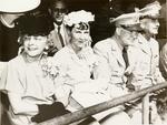 |
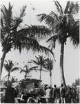
| Mamie Eisenhower (center) and General Dwight D. Eisenhower at Pratt General Hospital, former Biltmore Hotel. Coral Gables, Florida |
|
| Format: | |
8 X 10 in.
|
| Subjects.Display: | |
Coral Gables (Fla.)--History--Pictorial works
Historic sites--Florida
Hotels
Miami Biltmore Hotel & Country Club (Coral Gables, Fla)
Hospitals--Florida
Eisenhower, Dwight D. (Dwight David), 1890-1969
Eisenhower, Mamie Geneva Doud, 1896-1979
|
| Source Institution: | |
Florida International University
|
|
| Mamie Eisenhower (center) and General Dwight D. Eisenhower at Pratt General Hospital, former Biltmore Hotel. Coral Gables, Florida |
|
|
|
| Man |
|
| Creator: | |
Gleason, D. ( composer )
McKean ( Composer )
Leyden, Norman ( Performer )
Cloney, Rosemary ( Performer )
|
| Publisher.Display: | |
Columbia ( United States )
|
| Format: | |
1 sound disc : 78 rpm ; 10 in.
|
| Subjects.Display: | |
Popular music
|
| Source Institution: | |
Florida International University
|
| Donor: | |
Cristobal Diaz Ayala
|
|
| Man |
|
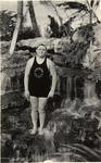 |
| Man (lifeguard) in a swimsuit at Venetian Pool. Coral Gables, Florida |
|
| Publication Date: | |
1924-01-09
|
| Creator: | |
Fishbaugh, W. A. (William A.)
|
| Format: | |
11 X 7 in.
|
| Subjects.Display: | |
Coral Gables (Fla.)--History--Pictorial works
Coral Gables (Fla.)--Buildings, structures, etc.--Pictorial works
Venetian Pool (Coral Gables, Fla)
Historic sites--Florida
Swimming pools
|
| Source Institution: | |
Florida International University
|
|
| Man (lifeguard) in a swimsuit at Venetian Pool. Coral Gables, Florida |
|
|
 |
| Man and older woman posing |
|
| Publication Date: | |
2004
|
| Subjects.Display: | |
Virginia Key Beach Park (Miami, Fla.)
|
| Source Institution: | |
Virginia Key Beach Park Trust
|
|
| Man and older woman posing |
|
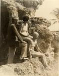 |
| Man and two women at the Venetian Pool. Coral Gables, Florida |
|
| Format: | |
10 X 8 in.
|
| Subjects.Display: | |
Coral Gables (Fla.)--History--Pictorial works
Coral Gables (Fla.)--Buildings, structures, etc.--Pictorial works
Swimming pools
Historic sites Florida
Venetian Pool (Coral Gables, Fla).
|
| Source Institution: | |
Florida International University
|
|
| Man and two women at the Venetian Pool. Coral Gables, Florida |
|
|
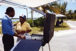 |
| Man and woman in front of machine |
|
| Publication Date: | |
2004
|
| Subjects.Display: | |
Virginia Key Beach Park (Miami, Fla.)
|
| Source Institution: | |
Virginia Key Beach Park Trust
|
|
| Man and woman in front of machine |
|
 |
| Man diving at the Venetian Pool. Coral Gables, Florida |
|
| Format: | |
10 X 8 in.
|
| Subjects.Display: | |
Coral Gables (Fla.)--History--Pictorial works
Coral Gables (Fla.)--Buildings, structures, etc.--Pictorial works
Venetian Pool (Coral Gables, Fla)
Swimming pools
Historic sites Florida
Diving
|
| Source Institution: | |
Florida International University
|
|
| Man diving at the Venetian Pool. Coral Gables, Florida |
|
|
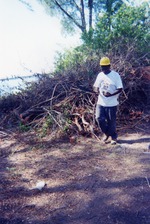 |
| Man in construction hat near tree debris |
|
| Publication Date: | |
2004
|
| Subjects.Display: | |
Virginia Key Beach Park (Miami, Fla.)
|
| Source Institution: | |
Virginia Key Beach Park Trust
|
|
| Man in construction hat near tree debris |
|
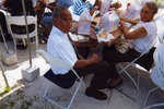 |
| Man in tie sitting at table |
|
| Publication Date: | |
2004
|
| Subjects.Display: | |
Virginia Key Beach Park (Miami, Fla.)
|
| Source Institution: | |
Virginia Key Beach Park Trust
|
|
| Man in tie sitting at table |
|
|
|
| A Man Is Brother To A Mule |
|
| Creator: | |
Roberts
Edmundo Ros and his Rumba Band
Fisher
|
| Publisher.Display: | |
Decca
|
| Format: | |
1 sound disc : 78 rpm ; 10 in.
|
| Source Institution: | |
Florida International University
|
| Donor: | |
Cristobal Diaz Ayala
|
|
| A Man Is Brother To A Mule |
|
 |
| A man must attain to three loves |
|
| Publication Date: | |
1967
|
| Creator: | |
Baumgard, Herbert M. (1920-2016)
|
| Subjects.Display: | |
Beth Am
Jewish sermons
|
| Source Institution: | |
Florida International University
|
| Donor: | |
Baumgard Family
|
|
| A man must attain to three loves |
|
|
 |
| Man reaching for hors d'ouvres |
|
| Publication Date: | |
2004
|
| Subjects.Display: | |
Virginia Key Beach Park (Miami, Fla.)
|
| Source Institution: | |
Virginia Key Beach Park Trust
|
|
| Man reaching for hors d'ouvres |
|
 |
| Man speaking from stage at event |
|
| Publication Date: | |
2004
|
| Subjects.Display: | |
Virginia Key Beach Park (Miami, Fla.)
|
| Source Institution: | |
Virginia Key Beach Park Trust
|
|
| Man speaking from stage at event |
|
|
|
| The Man Who Came to Rhumba |
|
| Creator: | |
André, Fabian ( Composer, Performer )
|
| Publisher.Display: | |
Columbia
|
| Format: | |
1 sound disc: 78 rpm; 10 in.
|
| Subjects.Display: | |
Popular music
|
| Source Institution: | |
Florida International University
|
| Donor: | |
Cristóbal Díaz Ayala
|
|
| The Man Who Came to Rhumba |
|
 |
| Management analyst intern program |
|
| Publication Date: | |
1974
|
| Creator: | |
Booz, Allen & Hamilton
|
| Publisher.Display: | |
Booz, Allen & Hamilton, Inc.
|
| Format: | |
2 v. in 1 : ill. ; 29 cm.
|
| Subjects.Display: | |
Miami-Dade County (Fla.)
Internship programs -- Florida -- Miami ( lcsh )
Management -- Employee participation -- Florida -- Miami ( lcsh )
|
| Source Institution: | |
Florida International University
|
|
| Management analyst intern program |
|

