| |
|
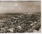 |
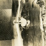
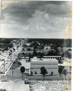
| Aerial view of Biltmore Hotel as Pratt General Hospital, Coral Gables, Florida |
|
| Subjects.Display: | |
Coral Gables (Fla.)--History--Pictorial works
Aerial views
Historic sites--Florida
Miami Biltmore Hotel & Country Club (Coral Gables, Fla.)
Hospitals--Florida
|
| Source Institution: | |
Florida International University
|
|
| Aerial view of Biltmore Hotel as Pratt General Hospital, Coral Gables, Florida |
|
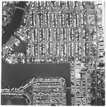 |
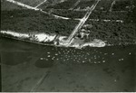
| Aerial view of Biscaya Island |
|
| Publication Date: | |
1958
|
| Publisher.Display: | |
Rader & Associates Engineers & Architects
|
| Format: | |
Series includes 22 photographs : ill. ; 23 x 23 cm.
|
| Subjects.Display: | |
Miami Beach (Fla.)--Aerial views.
|
| Source Institution: | |
City of Miami Beach
|
|
Aerial view of Biscaya Island
( 22 volumes ) |
|
|
 |
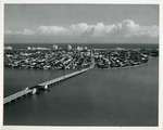
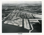
| Aerial view of Biscayne Bay Campus Florida International University |
|
| Publication Date: | |
2000/2010
|
| Creator: | |
Florida International University Media Services
|
| Format: | |
1 black and white print
|
| Subjects.Display: | |
Florida International University -- History
Florida International University -- Biscayne Bay Campus
Florida International University -- Aerial views
|
| Source Institution: | |
Florida International University
|
|
| Aerial view of Biscayne Bay Campus Florida International University |
|
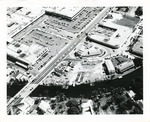 |
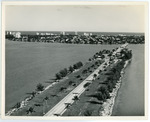
| Aerial view of Biscayne Shopping Plaza, NE 79 St. and Biscayne Blvd. |
|
| Publication Date: | |
1950-1959
|
| Format: | |
1 b&w photograph ; 8 x 10 inches
|
| Subjects.Display: | |
Roads -- Florida -- North Miami
Miami (Fla.) -- Aerial views
|
| Source Institution: | |
Greater North Miami Historical Society
|
|
| Aerial view of Biscayne Shopping Plaza, NE 79 St. and Biscayne Blvd. |
|
|
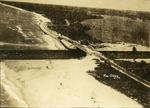 |
| Aerial view of Boynton inlet, 1935 |
|
| Publication Date: | |
1935
|
| Creator: | |
Ray B. Dame ( Photographer )
|
| Format: | |
1 black and white print; 6.75 x 5 inches
|
| Subjects.Display: | |
Aerial views
Bridges
Canals
aerial photographs
Boynton Inlet (Boynton Beach, Fla.)
Riddle Engineering Photoalbum
Bridge construction
|
| Source Institution: | |
Boynton Beach City Library Local History Archives
|
| Donor: | |
Gift of Linda Jackson.
|
|
| Aerial view of Boynton inlet, 1935 |
|
 |
| Aerial view of Boynton Inlet Bridge, March 1935 |
|
| Publication Date: | |
1935
|
| Creator: | |
Ray B. Dame ( Photographer )
|
| Format: | |
1 black and white print; 7.75 x 6.6 inches
|
| Subjects.Display: | |
Bridges
Waterways
Canals
aerial photographs
Boynton Inlet (Boynton Beach, Fla.)
Boynton Beach (Fla.)--Aerial views
Riddle Engineering Photoalbum
|
| Source Institution: | |
Boynton Beach City Library Local History Archives
|
| Donor: | |
Gift of Linda Jackson.
|
|
| Aerial view of Boynton Inlet Bridge, March 1935 |
|
|
 |
| Aerial View of Brickell Avenue |
|
| Publication Date: | |
1935
|
| Creator: | |
Hoit, Richard B. ( Photographer )
|
| Subjects.Display: | |
Aerial views
|
| Source Institution: | |
HistoryMiami Museum
|
|
| Aerial View of Brickell Avenue |
|
 |
| Aerial view of Broad Causeway bridge looking east to Bay Harbor Islands in Florida |
|
| Publication Date: | |
1961-12-06
|
| Creator: | |
Tierney and Killingswoth
|
| Format: | |
1 b&w Photograph; 8 x 10 inches
|
| Subjects.Display: | |
Bay Harbor Islands (Fla.) -- Aerial views
|
| Source Institution: | |
Greater North Miami Historical Society
|
|
| Aerial view of Broad Causeway bridge looking east to Bay Harbor Islands in Florida |
|
|
 |
| Aerial view of Broad Causeway looking east to Bay Harbor Islands in Florida |
|
| Publication Date: | |
1961-12-06
|
| Creator: | |
Tierney and Killingswoth
|
| Format: | |
1 b&w Photograph; 8 x 10 inches
|
| Subjects.Display: | |
Bay Harbor Islands (Fla.) -- Aerial views
|
| Source Institution: | |
Greater North Miami Historical Society
|
|
| Aerial view of Broad Causeway looking east to Bay Harbor Islands in Florida |
|
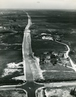 |
| Aerial view of Congress Avenue, c. 1962 |
|
| Publication Date: | |
1960/1965
|
| Creator: | |
Stan Sheets ( Photographer )
|
| Format: | |
1 black and white print; 9 x 8 inches
|
| Subjects.Display: | |
aerial photographs
Buildings
Boynton Beach Photograph Collection
Boynton Beach (Fla.) -- Aerial views
Dairy farming
|
| Source Institution: | |
Boynton Beach City Library Local History Archives
|
|
| Aerial view of Congress Avenue, c. 1962 |
|
|
 |
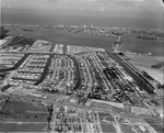
| Aerial view of construction on North Miami Campus Florida International University |
|
| Publication Date: | |
1979
|
| Creator: | |
Florida International University Media Services
|
| Format: | |
1 black and white print
|
| Subjects.Display: | |
Florida International University -- History
Florida International University -- Biscayne Bay Campus
Florida International University -- Aerial views
|
| Source Institution: | |
Florida International University
|
|
| Aerial view of construction on North Miami Campus Florida International University |
|
 |
| Aerial view of Coral Gables, Florida, Biltmore Hotel in center |
|
| Publication Date: | |
1931-04-25
|
| Format: | |
8 X 10 in.
|
| Subjects.Display: | |
Coral Gables (Fla.)--History--Pictorial works
Coral Gables (Fla.)--Buildings, structures, etc.--Pictorial works.
Aerial views
Historic sites--Florida
Miami Biltmore Hotel & Country Club (Coral Gables, Fla.)
|
| Source Institution: | |
Florida International University
|
|
| Aerial view of Coral Gables, Florida, Biltmore Hotel in center |
|
|
 |
| Aerial view of Coral Gables, Florida, Biltmore Hotel in center-upper left |
|
| Format: | |
8 X 10 in.
|
| Subjects.Display: | |
Coral Gables (Fla.)--History--Pictorial works
Coral Gables (Fla.)--Buildings, structures, etc.--Pictorial works
Aerial views
Historic sites--Florida
Miami Biltmore Hotel & Country Club (Coral Gables, Fla)
|
| Source Institution: | |
Florida International University
|
|
| Aerial view of Coral Gables, Florida, Biltmore Hotel in center-upper left |
|
 |
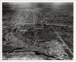
| Aerial view of East Oakland Park Blvd |
|
| Publication Date: | |
1974
|
| Creator: | |
Woodward, David ( Photographer )
|
| Format: | |
10 in x 8 in
|
| Subjects.Display: | |
Aerial views
Streets
Florida--Oakland Park (Broward County)
|
| Source Institution: | |
Ethel M. Gordon Oakland Park Library
|
|
| Aerial view of East Oakland Park Blvd |
|
|
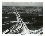 |
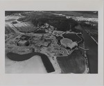
| Aerial view of Golden Glades Cloverleaf |
|
| Publication Date: | |
1950-1959
|
| Creator: | |
Ernie's Studio & Camera Center
|
| Format: | |
1 b&w photograph ; 8 x 10 inches
|
| Subjects.Display: | |
Roads -- Florida -- North Miami
Neighborhoods -- Florida -- North Miami
Golden Glades (Fla.) -- Aerial views
|
| Source Institution: | |
Greater North Miami Historical Society
|
|
| Aerial view of Golden Glades Cloverleaf |
|
 |
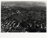
| Aerial View of Hollywood Boulevard and Environs (Hollywood, Fla.) |
|
| Publication Date: | |
1952-02-06
|
| Subjects.Display: | |
Aerial views
Hollywood (Fla.)
Young Circle Park (Hollywood, Fla.)
|
| Source Institution: | |
HistoryMiami Museum
|
|
| Aerial View of Hollywood Boulevard and Environs (Hollywood, Fla.) |
|
|
 |
| Aerial view of Keystone Islands in North Miami |
|
| Publication Date: | |
1950-1959
|
| Creator: | |
Ernie's Studio & Camera Center
|
| Format: | |
1 b&w photograph ; 8 x 10 inches
|
| Subjects.Display: | |
Roads -- Florida -- North Miami
North Miami (Fla.) -- Aerial views
Neighborhoods -- Florida -- North Miami
Keystone Islands (North Miami, Fla.)
|
| Source Institution: | |
Greater North Miami Historical Society
|
|
| Aerial view of Keystone Islands in North Miami |
|
 |
| Aerial view of Keystone Point |
|
| Publication Date: | |
1957-01-10
|
| Format: | |
1 b&w negative; 4x5 inches
|
| Subjects.Display: | |
North Miami (Fla.) -- Aerial views
Keystone Islands (North Miami, Fla.)
|
| Source Institution: | |
Greater North Miami Historical Society
|
|
| Aerial view of Keystone Point |
|
|
 |
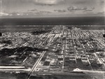
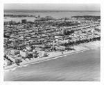
| Aerial view of Miami Beach looking north from 57th street |
|
| Publication Date: | |
1958
|
| Creator: | |
Hansen, Chris, ( Photographer )
|
| Format: | |
1 b&w aerial photograph : ill, ; 18 x 19 cm.
|
| Subjects.Display: | |
Streets--United States--Florida--Miami Beach--1950-1960.
Hotels--United States--Florida--Miami Beach--1950-1960.
Miami Beach (Fla.)--Aerial views.
Islands--United States--Florida--Miami Beach--1950-1960.
Waterways--1950-1960.
Bridges--1950-1960.
Beaches--United States--Florida--Miami Beach--1950-1960.
Apartment houses--United States--Florida--Miami Beach--1950-1960.
Causeways--1950-1960.
|
| Source Institution: | |
City of Miami Beach
|
|
| Aerial view of Miami Beach looking north from 57th street |
|
 |
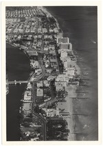
| Aerial view of Miami Beach looking west, 1964 |
|
| Publication Date: | |
1964
|
| Creator: | |
Hansen, Chris ( Photographer )
|
| Publisher.Display: | |
City of Miami Beach News Bureau, ( Miami Beach, Fla. : )
|
| Format: | |
1 photograph : ill. ; 20 x 25 cm.
|
| Measurements: | |
20 x 25
|
| Subjects.Display: | |
Miami Beach (Fla.)--Pictorial works.
Miami Beach (Fla.)--Buildings, structures, etc.--Pictorial works.
Miami Beach (Fla.)--Aerial views.
Beaches--United States--Florida--Miami Beach--1960-1970.
Ocean Drive (Miami Beach, Fla.)--1960-1970.
Aerial photographs.
|
| Source Institution: | |
City of Miami Beach
|
|
| Aerial view of Miami Beach looking west, 1964 |
|

