|
|
| |
|
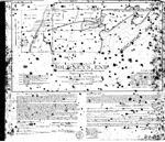 |
| Amended Plat Journey's End |
|
| Publication Date: | |
1936-08
|
| Creator: | |
Watson & Garris,Civil Engineers, Inc.
|
| Format: | |
map
|
| Subjects.Display: | |
Coral Gables (Fla.)
Miami-Dade County (Fla.)
Real property--Maps
Cadastral maps
Plat books
|
| Source Institution: | |
Florida International University
|
|
| Amended Plat Journey's End |
|
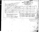 |
| Combined and Supplemental Map of MacFarlane Homestead Plat and St. Alban's Park |
|
| Publication Date: | |
1921-04-21
|
| Creator: | |
Watson, P.L.
Garris, M.G.
|
| Format: | |
map
|
| Subjects.Display: | |
Coral Gables (Fla.)
Miami-Dade County (Fla.)
Real property--Maps
Cadastral maps
Plat books
|
| Source Institution: | |
Florida International University
|
|
| Combined and Supplemental Map of MacFarlane Homestead Plat and St. Alban's Park |
|
|
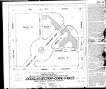 |
| Revised Plat of Douglas Section of Coral Gables |
|
| Publication Date: | |
1932-12
|
| Creator: | |
Watson & Garris,Civil Engineers, Inc.
|
| Format: | |
map
|
| Subjects.Display: | |
Coral Gables (Fla.)
Real property--Maps
Cadastral maps
Plat books
|
| Source Institution: | |
Florida International University
|
|
| Revised Plat of Douglas Section of Coral Gables |
|
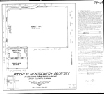 |
| Robert H. Montgomery Property |
|
| Publication Date: | |
1934-12
|
| Creator: | |
Watson & Garris,Civil Engineers, Inc.
|
| Format: | |
map
|
| Subjects.Display: | |
Coral Gables (Fla.)
Miami-Dade County (Fla.)
Real property--Maps
Cadastral maps
Plat books
|
| Source Institution: | |
Florida International University
|
|
| Robert H. Montgomery Property |
|
|
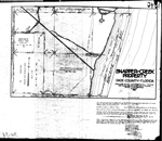 |
| Snapper Creek Property |
|
| Publication Date: | |
1932-08
|
| Creator: | |
Watson & Garris, Civil Engineers, Incorp.
|
| Format: | |
map
|
| Subjects.Display: | |
Coral Gables (Fla.)
Miami-Dade County (Fla.)
Real property--Maps
Cadastral maps
Plat books
|
| Source Institution: | |
Florida International University
|
|
| Snapper Creek Property |
|
|
|

