| |
|
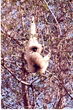 |
| Adult gibbon hanging from tree branches in its habitat at Miami Metrozoo |
|
| Publication Date: | |
1980/2000
|
| Creator: | |
Zoo Miami
|
| Format: | |
1 color photograph, 15 x 10 cm
|
| Subjects.Display: | |
Gibbons
Miami Metrozoo
Zoo animals
Zoo Miami
Zoos -- Exhibitions
|
| Source Institution: | |
Florida International University
|
|
| Adult gibbon hanging from tree branches in its habitat at Miami Metrozoo |
|
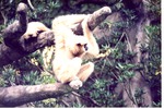 |
| Adult gibbon hanging on a branch while an infant crawls behind it at the Miami Metrozoo |
|
| Publication Date: | |
1980/2000
|
| Creator: | |
Zoo Miami
|
| Format: | |
1 color photograph, 15 x 10 cm
|
| Subjects.Display: | |
Gibbons
Miami Metrozoo
Zoo animals
Zoo Miami
Zoos -- Exhibitions
|
| Source Institution: | |
Florida International University
|
|
| Adult gibbon hanging on a branch while an infant crawls behind it at the Miami Metrozoo |
|
|
 |
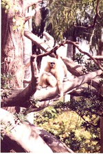
| Adult gibbon hanging with an infant gibbon on its knees at Miami Metrozoo |
|
| Publication Date: | |
1980/2000
|
| Creator: | |
Zoo Miami
|
| Format: | |
1 color photograph, 15 x 10 cm
|
| Subjects.Display: | |
Gibbons
Miami Metrozoo
Zoo animals
Zoo Miami
Zoos -- Exhibitions
|
| Source Institution: | |
Florida International University
|
|
| Adult gibbon hanging with an infant gibbon on its knees at Miami Metrozoo |
|
 |
| Adult gibbon holding its infant on its knees as it swings through its habitat at Miami Metrozoo |
|
| Publication Date: | |
1980/2000
|
| Creator: | |
Zoo Miami
|
| Format: | |
1 color photograph, 15 x 10 cm
|
| Subjects.Display: | |
Gibbons
Miami Metrozoo
Zoo animals
Zoo Miami
Zoos -- Exhibitions
|
| Source Institution: | |
Florida International University
|
|
| Adult gibbon holding its infant on its knees as it swings through its habitat at Miami Metrozoo |
|
|
 |
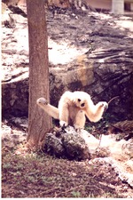
| Adult gibbon resting on habitat structure at Miami Metrozoo |
|
| Publication Date: | |
1980/2000
|
| Creator: | |
Zoo Miami
|
| Format: | |
1 color photograph, 15 x 10 cm
|
| Subjects.Display: | |
Gibbons
Miami Metrozoo
Zoo animals
Zoo Miami
Zoos -- Exhibitions
|
| Source Institution: | |
Florida International University
|
|
| Adult gibbon resting on habitat structure at Miami Metrozoo |
|
 |
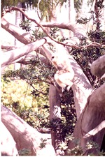
| Adult gibbon seated on a rock at the base of a tree in its habitat at Miami Metrozoo |
|
| Publication Date: | |
1980/2000
|
| Creator: | |
Zoo Miami
|
| Format: | |
1 color photograph, 15 x 10 cm
|
| Subjects.Display: | |
Gibbons
Miami Metrozoo
Zoo animals
Zoo Miami
Zoos -- Exhibitions
|
| Source Institution: | |
Florida International University
|
|
| Adult gibbon seated on a rock at the base of a tree in its habitat at Miami Metrozoo |
|
|
 |
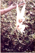
| Adult gibbon swinging its way through the habitat with its infant at Miami Metrozoo |
|
| Publication Date: | |
1980/2000
|
| Creator: | |
Zoo Miami
|
| Format: | |
1 color photograph, 15 x 10 cm
|
| Subjects.Display: | |
Gibbons
Miami Metrozoo
Zoo animals
Zoo Miami
Zoos -- Exhibitions
|
| Source Institution: | |
Florida International University
|
|
| Adult gibbon swinging its way through the habitat with its infant at Miami Metrozoo |
|
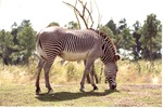 |
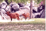
| Adult Grevy's zebra grazing in its habitat at Miami Metrozoo |
|
| Publication Date: | |
1980/2000
|
| Creator: | |
Zoo Miami
|
| Format: | |
1 color photograph, 15 x 10 cm
|
| Subjects.Display: | |
Miami Metrozoo
Grevy's zebra
Zoo animals
Zoo Miami
Zoos -- Exhibition
Zebra
|
| Source Institution: | |
Florida International University
|
|
| Adult Grevy's zebra grazing in its habitat at Miami Metrozoo |
|
|
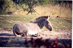 |
| Adult Grevy's zebra laying in the sun in its field at Miami Metrozoo |
|
| Publication Date: | |
1980/2000
|
| Creator: | |
Zoo Miami
|
| Format: | |
1 color photograph, 15 x 10 cm
|
| Subjects.Display: | |
Miami Metrozoo
Grevy's zebra
Zoo animals
Zoo Miami
Zoos -- Exhibition
Zebra
|
| Source Institution: | |
Florida International University
|
|
| Adult Grevy's zebra laying in the sun in its field at Miami Metrozoo |
|
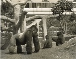 |
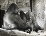
| Adult Lowland Gorilla and two younger gorillas in Miami Metrozoo with Monorail passing behind |
|
| Publication Date: | |
1970/1990
|
| Creator: | |
Zoo Miami
|
| Format: | |
1 b&w photograph, 25.5 x 20.5 cm
|
| Subjects.Display: | |
Miami Metrozoo
Gorilla
Zoo animals
Zoo Miami
Zoos -- Exhibitions
|
| Source Institution: | |
Florida International University
|
|
| Adult Lowland Gorilla and two younger gorillas in Miami Metrozoo with Monorail passing behind |
|
|
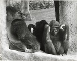 |
| Adult lowland gorilla and younger gorilla lean back against the window at the Miami Metrozoo |
|
| Publication Date: | |
1970/1990
|
| Creator: | |
Zoo Miami
|
| Format: | |
1 b&w photograph, 25 x 20 cm
|
| Subjects.Display: | |
Miami Metrozoo
Gorilla
Zoo animals
Zoo Miami
Zoos -- Exhibitions
|
| Source Institution: | |
Florida International University
|
|
| Adult lowland gorilla and younger gorilla lean back against the window at the Miami Metrozoo |
|
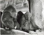 |
| Adult lowland gorilla looking at younger gorilla at Miami Metrozoo |
|
| Publication Date: | |
1970 /1990
|
| Creator: | |
Zoo Miami
|
| Format: | |
1 b&w photograph, 25 x 20 cm
|
| Subjects.Display: | |
Miami Metrozoo
Gorilla
Zoo animals
Zoo Miami
Zoos -- Exhibitions
|
| Source Institution: | |
Florida International University
|
|
| Adult lowland gorilla looking at younger gorilla at Miami Metrozoo |
|
|
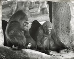 |
| Adult lowland gorilla looks at camera while young gorilla looks at rocks at Miami Metrozoo |
|
| Publication Date: | |
1970/1990
|
| Creator: | |
Zoo Miami
|
| Format: | |
1 b&w photograph, 25 x 20 cm
|
| Subjects.Display: | |
Miami Metrozoo
Gorilla
Zoo animals
Zoo Miami
Zoos -- Exhibitions
|
| Source Institution: | |
Florida International University
|
|
| Adult lowland gorilla looks at camera while young gorilla looks at rocks at Miami Metrozoo |
|
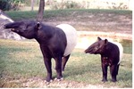 |
| Adult Malayan tapir with its young standing in their habitat at Miami Metrozoo |
|
| Publication Date: | |
1980/2000
|
| Creator: | |
Zoo Miami
|
| Format: | |
1 color photograph, 15 x 10 cm
|
| Subjects.Display: | |
Miami Metrozoo
Tapirs
Zoo animals
Zoo Miami
Zoos -- Exhibitions
Tapiridae
Tapirus indicus
|
| Source Institution: | |
Florida International University
|
|
| Adult Malayan tapir with its young standing in their habitat at Miami Metrozoo |
|
|
 |
| Adult male Bongo antelope and his young in habitat pool at Miami Metrozoo |
|
| Publication Date: | |
1980/2000
|
| Creator: | |
Zoo Miami
|
| Format: | |
1 color photograph, 15 x 10 cm
|
| Subjects.Display: | |
Antelopes
Miami Metrozoo
Zoo animals
Zoo Miami
Zoos -- Exhibitions
Bongo antelope
|
| Source Institution: | |
Florida International University
|
|
| Adult male Bongo antelope and his young in habitat pool at Miami Metrozoo |
|
 |
| Adult male lowland gorilla and young one at the Miami Metrozoo |
|
| Publication Date: | |
1970/1990
|
| Creator: | |
Zoo Miami
|
| Format: | |
1 b&w photograph, 25 x 20 cm
|
| Subjects.Display: | |
Miami Metrozoo
Gorilla
Zoo animals
Zoo Miami
Zoos -- Exhibitions
|
| Source Institution: | |
Florida International University
|
|
| Adult male lowland gorilla and young one at the Miami Metrozoo |
|
|
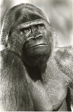 |
| Adult male Lowland gorilla at the Miami Metrozoo |
|
| Publication Date: | |
1970/1990
|
| Creator: | |
Zoo Miami
|
| Format: | |
1 b&w photograph, 25 x 20 cm
|
| Subjects.Display: | |
Miami Metrozoo
Gorilla
Zoo animals
Zoo Miami
Zoos -- Exhibitions
|
| Source Institution: | |
Florida International University
|
|
| Adult male Lowland gorilla at the Miami Metrozoo |
|
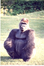 |
| Adult male lowland gorilla crouched in its habitat at Miami Metrozoo |
|
| Publication Date: | |
1980/2000
|
| Creator: | |
Zoo Miami
|
| Format: | |
1 color photograph, 15 x 10 cm
|
| Subjects.Display: | |
Miami Metrozoo
Gorilla
Zoo animals
Zoo Miami
Zoos -- Exhibitions
|
| Source Institution: | |
Florida International University
|
|
| Adult male lowland gorilla crouched in its habitat at Miami Metrozoo |
|
|
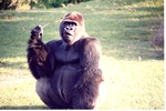 |
| Adult male lowland gorilla holding a stick while seated in its habitat at Miami Metrozoo |
|
| Publication Date: | |
1980/2000
|
| Creator: | |
Zoo Miami
|
| Format: | |
1 color photograph, 15 x 10 cm
|
| Subjects.Display: | |
Miami Metrozoo
Gorilla
Zoo animals
Zoo Miami
Zoos -- Exhibitions
|
| Source Institution: | |
Florida International University
|
|
| Adult male lowland gorilla holding a stick while seated in its habitat at Miami Metrozoo |
|
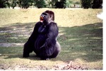 |
| Adult male lowland gorilla howling in its habitat at Miami Metrozoo |
|
| Publication Date: | |
1980/2000
|
| Creator: | |
Zoo Miami
|
| Format: | |
1 color photograph, 15 x 10 cm
|
| Subjects.Display: | |
Miami Metrozoo
Gorilla
Zoo animals
Zoo Miami
Zoos -- Exhibitions
|
| Source Institution: | |
Florida International University
|
|
| Adult male lowland gorilla howling in its habitat at Miami Metrozoo |
|

