| |
|
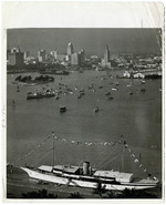 |
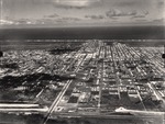
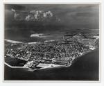
| Aerial View of Downtown Miami and Biscayne Bay |
|
| Publication Date: | |
1920/1949
|
| Publisher.Display: | |
Miami News
|
| Format: | |
8”x10” Black and white photograph
|
| Subjects.Display: | |
Biscayne Bay (Fla.)
Boats and boating
|
| Source Institution: | |
HistoryMiami Museum
|
|
| Aerial View of Downtown Miami and Biscayne Bay |
|
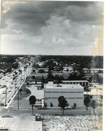 |
| Aerial view of East Oakland Park Blvd |
|
| Publication Date: | |
1974
|
| Creator: | |
Woodward, David ( Photographer )
|
| Format: | |
10 in x 8 in
|
| Subjects.Display: | |
Aerial views
Streets
Florida--Oakland Park (Broward County)
|
| Source Institution: | |
Ethel M. Gordon Oakland Park Library
|
|
| Aerial view of East Oakland Park Blvd |
|
|
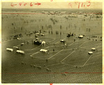 |
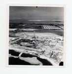
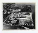
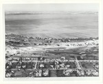
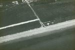
| Aerial view of flooded rural area |
|
| Publication Date: | |
1947-10-14
|
| Publisher.Display: | |
Miami News
|
| Format: | |
8 x10” black and white print
|
| Subjects.Display: | |
Natural disasters
Floods -- Florida -- Miami -- Photographs
|
| Source Institution: | |
HistoryMiami Museum
|
|
| Aerial view of flooded rural area |
|
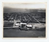 |
| Aerial view of Fort Taylor looking northeast across Key West |
|
| Publication Date: | |
1936
|
| Creator: | |
Monroe County Public Library System
Aero-Graphic Corp
Thompson Family Collection
May Hill Russell Library -- History Dept
|
| Format: | |
1 photograph : b&w ; 8 x 10 in.
|
| Subjects.Display: | |
Monroe -- 12087
Aerial photographs -- Monroe County (Fla.)
Buildings, structures, etc -- Aerial photographs -- Key West (Fla.)
Aerial photographs -- Key West (Fla.)
Aerial photographs -- Fort Zachary Taylor (Key West, Fla.)
|
| Source Institution: | |
Florida International University
|
|
| Aerial view of Fort Taylor looking northeast across Key West |
|
|
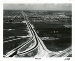 |
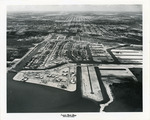
| Aerial view of Golden Glades Cloverleaf |
|
| Publication Date: | |
1950-1959
|
| Creator: | |
Ernie's Studio & Camera Center
|
| Format: | |
1 b&w photograph ; 8 x 10 inches
|
| Subjects.Display: | |
Roads -- Florida -- North Miami
Neighborhoods -- Florida -- North Miami
Golden Glades (Fla.) -- Aerial views
|
| Source Institution: | |
Greater North Miami Historical Society
|
|
| Aerial view of Golden Glades Cloverleaf |
|
 |
| Aerial view of Government Road and salt ponds taken December 19th, 1945 |
|
| Publication Date: | |
1945
|
| Creator: | |
Monroe County Public Library System
May Hill Russell Library -- History Dept
Ida Woodward Barron Collection
|
| Format: | |
1 photograph : b&w ; 7 x 7 in.
|
| Subjects.Display: | |
Photographs -- Key West (Fla.)
Monroe -- 12087
Aerial photographs -- Monroe County (Fla.)
Airports -- Aerial photographs -- Florida -- Key West
Bunkers (Fortification) -- Aerial Photographs -- Florida -- Key West
Roads -- Aerial photographs -- Florida -- Key West
Bridges -- Aerial photographs -- Florida -- Key West
Railroad bridges -- Aerial photographs -- Key West (Fla.)
|
| Source Institution: | |
Florida International University
|
|
| Aerial view of Government Road and salt ponds taken December 19th, 1945 |
|
|
 |
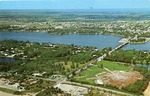
| Aerial view of Greater Miami Shores area |
|
| Publication Date: | |
1948-06-08
|
| Subjects.Display: | |
Municipal officials and employees
Golf Course
|
| Source Institution: | |
Brockway Memorial Library
|
|
| Aerial view of Greater Miami Shores area |
|
 |
| Aerial view of Holiday Isle Resort |
|
| Subjects.Display: | |
Islamorada (Fla.)
aerial photographs
lcsh
lcnaf
|
| Source Institution: | |
Florida International University
|
|
| Aerial view of Holiday Isle Resort |
|
|
 |
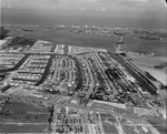
| Aerial View of Hollywood Boulevard and Environs (Hollywood, Fla.) |
|
| Publication Date: | |
1952-02-06
|
| Subjects.Display: | |
Aerial views
Hollywood (Fla.)
Young Circle Park (Hollywood, Fla.)
|
| Source Institution: | |
HistoryMiami Museum
|
|
| Aerial View of Hollywood Boulevard and Environs (Hollywood, Fla.) |
|
 |
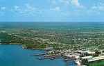
| Aerial view of Hotel Casa Marina looking northeast to Garrison Bight |
|
| Publication Date: | |
1930
|
| Creator: | |
Monroe County Public Library System
May Hill Russell Library -- History Dept
Warren Family Collection
|
| Format: | |
1 photograph : b&w ; 8 x 10 in.
|
| Subjects.Display: | |
Monroe -- 12087
Aerial photographs -- Monroe County (Fla.)
Buildings, structures, etc -- Aerial photographs -- Key West (Fla.)
Aerial photographs -- Key West (Fla.)
Hotels -- Aerial photographs -- Florida -- Key West
Streets -- Aerial photographs -- Florida -- Key West
|
| Source Institution: | |
Florida International University
|
|
| Aerial view of Hotel Casa Marina looking northeast to Garrison Bight |
|
|
 |
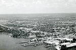
| An aerial view of Key West Bight & the Navy's Trumbo Point |
|
| Publication Date: | |
1941
|
| Creator: | |
Monroe County Public Library System
May Hill Russell Library -- History Dept
Key West Art & Historical Society
|
| Format: | |
1 photograph : b&w ; 8 x 10 in.
|
| Subjects.Display: | |
Monroe -- 12087
Aerial photographs -- Monroe County (Fla.)
Aerial photographs -- Key West (Fla.)
Bays -- Aerial photographs -- Florida -- Key West
Aerial photographs -- Naval station Key West (Fla.)
|
| Source Institution: | |
Florida International University
|
|
| An aerial view of Key West Bight & the Navy's Trumbo Point |
|
 |
| An aerial view of Key West from White Street to the Airport |
|
| Publication Date: | |
1960/1969
|
| Creator: | |
Monroe County Public Library System
May Hill Russell Library -- History Dept
|
| Format: | |
1 photograph : b&w ; 8 x 10 in.
|
| Subjects.Display: | |
Monroe -- 12087
Aerial photographs -- Monroe County (Fla.)
Aerial photographs -- Key West (Fla.)
Airports -- Aerial photographs -- Florida -- Key West
Roads -- Aerial photographs -- Florida -- Key West
|
| Source Institution: | |
Florida International University
|
| Donor: | |
Westray, Bill
|
|
| An aerial view of Key West from White Street to the Airport |
|
|
 |
| An aerial view of Key West looking northeast past Sigbee Park |
|
| Publication Date: | |
1950
|
| Creator: | |
Monroe County Public Library System
May Hill Russell Library -- History Dept
|
| Format: | |
1 photograph : b&w ; 8 x 10 in.
|
| Subjects.Display: | |
Monroe -- 12087
Aerial photographs -- Monroe County (Fla.)
Buildings, structures, etc -- Aerial photographs -- Key West (Fla.)
Aerial photographs -- Key West (Fla.)
Aerial photographs -- Fort Zachary Taylor (Key West, Fla.)
|
| Source Institution: | |
Florida International University
|
| Donor: | |
Simmons, John, 1942-1987, 1942-1987, 1942-1987, 1942-1987, 1942-1987
|
|
| An aerial view of Key West looking northeast past Sigbee Park |
|
 |
| Aerial view of Keystone Islands in North Miami |
|
| Publication Date: | |
1950-1959
|
| Creator: | |
Ernie's Studio & Camera Center
|
| Format: | |
1 b&w photograph ; 8 x 10 inches
|
| Subjects.Display: | |
Roads -- Florida -- North Miami
North Miami (Fla.) -- Aerial views
Neighborhoods -- Florida -- North Miami
Keystone Islands (North Miami, Fla.)
|
| Source Institution: | |
Greater North Miami Historical Society
|
|
| Aerial view of Keystone Islands in North Miami |
|
|
 |
| Aerial view of Keystone Point |
|
| Publication Date: | |
1957-01-10
|
| Format: | |
1 b&w negative; 4x5 inches
|
| Subjects.Display: | |
North Miami (Fla.) -- Aerial views
Keystone Islands (North Miami, Fla.)
|
| Source Institution: | |
Greater North Miami Historical Society
|
|
| Aerial view of Keystone Point |
|
 |
| Aerial view of La Gorce golf course |
|
| Publication Date: | |
1930
|
| Creator: | |
Miami Beach Visitor & Convention Authority
|
| Publisher.Display: | |
Miami Beach Visitor and Convention Authority, ( Miami Beach, Fla. : )
|
| Format: | |
1 photograph: ill, ; 20 x 24 cm.
|
| Measurements: | |
20 x 24
|
| Subjects.Display: | |
Miami Beach (Fla.)--Buildings, structures, etc.--Pictorial works.
Miami Beach (Fla.)--Aerial photographs.
Houses--1920-1930.
Streets--1930-1940.
Golf courses--1930-1940.
Lakes and ponds--1920-1930.
|
| Source Institution: | |
City of Miami Beach
|
|
| Aerial view of La Gorce golf course |
|
|
 |
| Aerial view of Lantana beach, c. 1935 |
|
| Publication Date: | |
1930/199
|
| Format: | |
1 black and white slide; 1 x .7 inches
|
| Subjects.Display: | |
Beaches
aerial photographs
Mary Linehan Slide Collection
Lake Worth (Fla. : Lake)
|
| Source Institution: | |
Boynton Beach City Library Local History Archives
|
| Donor: | |
Scan gift of Lantana Public Library.
|
|
| Aerial view of Lantana beach, c. 1935 |
|
 |
| Aerial view of Lantana, Florida, c. 1955 |
|
| Publication Date: | |
1950/1959
|
| Creator: | |
Larry Witt ( Photographer )
|
| Publisher.Display: | |
D & M Post Cards & Records Co. (West Palm Beach, Fla.)
|
| Format: | |
1 color postcard; 5.5 x 3.5 inches
|
| Subjects.Display: | |
Bridges
aerial photographs
Postcards
Mary Linehan Postcard Collection
Photographic postcards
|
| Source Institution: | |
Boynton Beach City Library Local History Archives
|
| Donor: | |
Gift of Lantana Public Library.
|
|
| Aerial view of Lantana, Florida, c. 1955 |
|
|
 |
| Aerial view of Lantana, Florida, c. 1955 |
|
| Publication Date: | |
1950/1959
|
| Creator: | |
Larry Witt ( Photographer )
|
| Publisher.Display: | |
D & M Post Cards & Records Co. (West Palm Beach, Fla.)
|
| Format: | |
1 color postcard; 5.5 x 3.5 inches
|
| Subjects.Display: | |
aerial photographs
Postcards
Marinas
Mary Linehan Postcard Collection
Photographic postcards
|
| Source Institution: | |
Boynton Beach City Library Local History Archives
|
| Donor: | |
Gift of Lantana Public Library.
|
|
| Aerial view of Lantana, Florida, c. 1955 |
|
 |
| Aerial view of Lantana Florida, c. 1970s |
|
| Publication Date: | |
1970/1979
|
| Format: | |
1 black and white slide; 1 x .7 inches
|
| Subjects.Display: | |
aerial photographs
Marinas
Lake Worth (Lake Worth, Fla.)
Mary Linehan Slide Collection
|
| Source Institution: | |
Boynton Beach City Library Local History Archives
|
| Donor: | |
Scan gift of Lantana Public Library.
|
|
| Aerial view of Lantana Florida, c. 1970s |
|

