| |
|
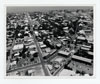 |
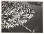
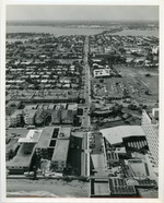
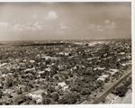
| Aerial view looking south on Duval Street |
|
| Publication Date: | |
1970
|
| Creator: | |
Monroe County Public Library System
May Hill Russell Library -- History Dept
United States -- Navy
|
| Format: | |
1 photograph : b&w ; 8 x 10 in.
|
| Subjects.Display: | |
Monroe -- 12087
Aerial photographs -- Monroe County (Fla.)
Buildings, structures, etc -- Aerial photographs -- Key West (Fla.)
Aerial photographs -- Key West (Fla.)
|
| Source Institution: | |
Florida International University
|
|
| Aerial view looking south on Duval Street |
|
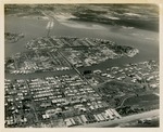 |
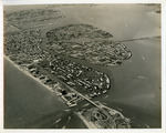
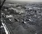
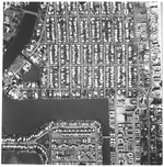
| Aerial view looking west at Surfside, Bal Harbour, Bay Harbor, and North Miami |
|
| Publication Date: | |
1952-04-12
|
| Creator: | |
McKay Aerial Photos
|
| Format: | |
1 b&w photograph ; 8 x 10 inches
|
| Subjects.Display: | |
North Miami (Fla.) -- Aerial views
|
| Source Institution: | |
Greater North Miami Historical Society
|
|
| Aerial view looking west at Surfside, Bal Harbour, Bay Harbor, and North Miami |
|
|
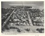 |
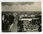
| Aerial view looking west from Meridian Avenue and Lincoln Road. |
|
| Publication Date: | |
1923
|
| Format: | |
1 photograph : ill. ; 19 x 25 cm.
|
| Measurements: | |
19 x 25
|
| Subjects.Display: | |
Miami Beach (Fla.)--Aerial photographs.
Islands--1920-1930.
Construction--1920-1930.
Lincoln Road (Miami Beach, Fla.)--1920-1930.
Golf courses--1920-1930.
|
| Source Institution: | |
City of Miami Beach
|
|
| Aerial view looking west from Meridian Avenue and Lincoln Road. |
|
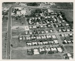 |
| Aerial view of 125th. Street to Florida East Coast railway in 1958 |
|
| Publication Date: | |
1958
|
| Format: | |
1 b&w photograph ; 8 x 10 inches
|
| Subjects.Display: | |
North Miami (Fla.) -- Aerial views
|
| Source Institution: | |
Greater North Miami Historical Society
|
|
| Aerial view of 125th. Street to Florida East Coast railway in 1958 |
|
|
 |
| Aerial view of 70th Street Causeway and Bay Drive |
|
| Publication Date: | |
1956
|
| Creator: | |
City of Miami Beach
|
| Subjects.Display: | |
Miami Beach (Fla.)--Pictorial works.
Public libraries
|
| Source Institution: | |
City of Miami Beach
|
|
Aerial view of 70th Street Causeway and Bay Drive
( 2 volumes ) |
|
 |
| Aerial View of a Street Scene in Miami Showing Residences, Commercial Buildings, Traffic and Trolleys Running |
|
| Publication Date: | |
1930
|
| Creator: | |
Hoit, Richard B.
|
| Format: | |
8 x 10 Black and white print
|
| Source Institution: | |
HistoryMiami Museum
|
|
| Aerial View of a Street Scene in Miami Showing Residences, Commercial Buildings, Traffic and Trolleys Running |
|
|
 |
| Aerial view of Army tower |
|
| Publication Date: | |
1945
|
| Creator: | |
Monroe County Public Library System
May Hill Russell Library -- History Dept
Ida Woodward Barron Collection
|
| Format: | |
1 photograph : b&w ; 7 x 7 in.
|
| Subjects.Display: | |
Monroe -- 12087
Aerial photographs -- Monroe County (Fla.)
Aerial photographs -- Key West (Fla.)
Shorelines -- Aerial Photographs -- Key West (Fla.)
Water towers -- Aerial photographs -- Florida -- Key West
|
| Source Institution: | |
Florida International University
|
|
| Aerial view of Army tower |
|
 |
| Aerial view of Bal Harbour, Bay Harbor Islands and Indian Creek in Florida |
|
| Publication Date: | |
1957-03-14
|
| Creator: | |
Tierney and Killingswoth
|
| Format: | |
1 b&w Photograph; 8 x 10 inches
|
| Subjects.Display: | |
Bay Harbor Islands (Fla.) -- Aerial views
Bal Harbour (Fla.) -- Aerial views
Indian Creek Village (Fla.) -- Aerial views
|
| Source Institution: | |
Greater North Miami Historical Society
|
|
| Aerial view of Bal Harbour, Bay Harbor Islands and Indian Creek in Florida |
|
|
 |
| Aerial view of Bal Harbour, Florida |
|
| Publication Date: | |
1961-12-06
|
| Creator: | |
Tierney and Killingswoth
|
| Format: | |
1 b&w Photograph; 8 x 10 inches
|
| Subjects.Display: | |
Bal Harbour (Fla.) -- Aerial views
|
| Source Institution: | |
Greater North Miami Historical Society
|
|
| Aerial view of Bal Harbour, Florida |
|
 |
| Aerial view of Barry College |
|
| Publication Date: | |
1951-07-15
|
| Format: | |
1 b&w negative; 4x5 inches
|
| Subjects.Display: | |
Associations, institutions, etc. -- Florida -- North Miami
Barry University -- Pictorial works
|
| Source Institution: | |
Greater North Miami Historical Society
|
|
| Aerial view of Barry College |
|
|
 |
| Aerial View of Beach (Fort LauderdaleFla) |
|
| Publication Date: | |
@1950-12-10
|
| Creator: | |
Miami News
|
| Publisher.Display: | |
Miami News
|
| Subjects.Display: | |
Seaside resorts
Fort Lauderdale (Fla.)
Lauderdale Beach Hotel (Fort Lauderdale, Fla.)
|
| Source Institution: | |
HistoryMiami Museum
|
|
| Aerial View of Beach (Fort LauderdaleFla) |
|
 |
| Aerial view of beach area |
|
| Subjects.Display: | |
Palms
aerial photographs
Virginia Key Beach Park (Miami, Fla.)
African Americans--Segregation
|
| Source Institution: | |
Virginia Key Beach Park Trust
|
|
| Aerial view of beach area |
|
|
 |
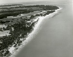
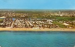
| Aerial view of beach with groynes, c. 1927 |
|
| Publication Date: | |
1925/1927
|
| Creator: | |
Ray B. Dame ( Photographer )
|
| Format: | |
1 black and white print; 6.5 x 4.5 inches
|
| Subjects.Display: | |
Waterways
Coastlines
Beaches
Groins (Shore protection)
Riddle Engineering Company
Riddle Engineering Photoalbum
|
| Source Institution: | |
Boynton Beach City Library Local History Archives
|
| Donor: | |
Gift of Linda Jackson.
|
|
| Aerial view of beach with groynes, c. 1927 |
|
 |
| Aerial view of Biltmore Hotel as Pratt General Hospital, Coral Gables, Florida |
|
| Subjects.Display: | |
Coral Gables (Fla.)--History--Pictorial works
Aerial views
Historic sites--Florida
Miami Biltmore Hotel & Country Club (Coral Gables, Fla.)
Hospitals--Florida
|
| Source Institution: | |
Florida International University
|
|
| Aerial view of Biltmore Hotel as Pratt General Hospital, Coral Gables, Florida |
|
|
 |
| Aerial view of Biscaya Island |
|
| Publication Date: | |
1958
|
| Publisher.Display: | |
Rader & Associates Engineers & Architects
|
| Format: | |
Series includes 22 photographs : ill. ; 23 x 23 cm.
|
| Subjects.Display: | |
Miami Beach (Fla.)--Aerial views.
|
| Source Institution: | |
City of Miami Beach
|
|
Aerial view of Biscaya Island
( 22 volumes ) |
|
|
| Aerial view of Biscayne Bay Campus Florida International University |
|
| Publication Date: | |
2000/2010
|
| Creator: | |
Florida International University Media Services
|
| Format: | |
1 black and white print
|
| Subjects.Display: | |
Florida International University -- History
Florida International University -- Biscayne Bay Campus
Florida International University -- Aerial views
|
| Source Institution: | |
Florida International University
|
|
| Aerial view of Biscayne Bay Campus Florida International University |
|
|
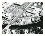 |
| Aerial view of Biscayne Shopping Plaza, NE 79 St. and Biscayne Blvd. |
|
| Publication Date: | |
1950-1959
|
| Format: | |
1 b&w photograph ; 8 x 10 inches
|
| Subjects.Display: | |
Roads -- Florida -- North Miami
Miami (Fla.) -- Aerial views
|
| Source Institution: | |
Greater North Miami Historical Society
|
|
| Aerial view of Biscayne Shopping Plaza, NE 79 St. and Biscayne Blvd. |
|
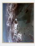 |
| An aerial view of Boca Chica |
|
| Publication Date: | |
1970
|
| Creator: | |
Monroe County Public Library System
May Hill Russell Library -- History Dept
Ida Woodward Barron Collection
|
| Format: | |
1 photograph : color ; 11 x 13 in.
|
| Subjects.Display: | |
Monroe -- 12087
Aerial photographs -- Monroe County (Fla.)
Airplanes -- Aerial photographs -- Florida -- Monroe County
|
| Source Institution: | |
Florida International University
|
|
| An aerial view of Boca Chica |
|
|
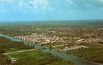 |
| Aerial view of Boynton Beach, 1970 |
|
| Publication Date: | |
1970
|
| Publisher.Display: | |
D & M Post Cards & Records (West Palm Beach, Fla.)
|
| Format: | |
1 color postcard; 5.5 x 3.5 inches
|
| Subjects.Display: | |
Bridges
aerial photographs
Intracoastal waterways
Landscapes
Advertising--Tourism
Postcard Collection
|
| Source Institution: | |
Boynton Beach City Library Local History Archives
|
| Donor: | |
Gift of Norman Cook.
|
|
| Aerial view of Boynton Beach, 1970 |
|
 |
| Aerial view of Boynton Beach and Briny Breezes, c. 1967 |
|
| Publication Date: | |
1960/1969
|
| Publisher.Display: | |
D & M Post Cards & Records Co. (West Palm Beach, Fla.)
|
| Format: | |
1 color postcard; 5.5 x 35 inches
|
| Subjects.Display: | |
aerial photographs
Landscapes
Briny Breezes (Fla.)
Photographic postcards
Janet DeVries Naughton Collection
|
| Source Institution: | |
Boynton Beach City Library Local History Archives
|
| Donor: | |
Gift of Janet DeVries Naughton.
|
|
| Aerial view of Boynton Beach and Briny Breezes, c. 1967 |
|

