|
|
|
|
   |
Go to thumbnail:
|
|
|
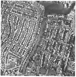
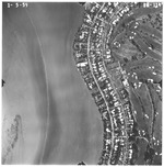
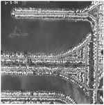
| Photograph, recto: [Aerial view of Surprise Lake and Biscayne Waterway] |

|
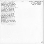
| Photograph, verso: Rader & Associates Engineers and Architects |
|
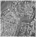
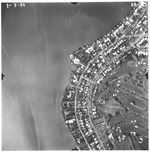
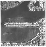
| Photograph, recto: [Aerial view of Surprise Lake, Surprise Waterway and Biscayne Waterway] |

|
| Photograph, verso: Rader & Associates Engineers and Architects |
|
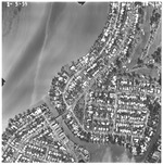
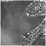
| Photograph, recto: [Aerial view of Surprise Lake and Surprise Waterway. The La Gorce Country Club is on the right] |

|
| Photograph, verso: Rader & Associates Engineers and Architects |
|
| Photograph, recto: [View of the La Gorce Country Club and Biscayne Bay] |

|
| Photograph, verso: Rader & Associates Engineers and Architects |
|
| Photograph, recto: [View of the La Gorce Country Club and Biscayne Bay] |

|
| Photograph, verso: Rader & Associates Engineers and Architects |
|
| Photograph, recto: [View of the La Gorce golf course, houses along Alton Road and Biscayne Bay] |

|
| Photograph, verso: Rader & Associates Engineers and Architects |
|
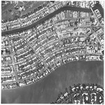
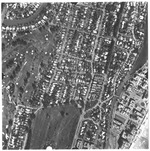
| Photograph, recto: [View of La Gorce Island, the La Gorce golf course, houses along Alton Road and Biscayne Bay] |

|
| Photograph, verso: Rader & Associates Engineers and Architects |

|
| Photograph, recto: [View of La Gorce Island and Normandy Isle] |

|
| Photograph, verso: Rader & Associates Engineers and Architects |
|
| Photograph, recto: [View of Normandy Isle and the Normandy Waterway] |

|
| Photograph, verso: Rader & Associates Engineers and Architects |
|
| Photograph, recto: [View of Normandy Isle, the Normandy Shores Golf Club and the Normandy Waterway] |

|
| Photograph, verso: Rader & Associates Engineers and Architects |
|
| Photograph, recto: [View of oceanfront buildings and beaches] |
|
| Photograph, verso: Rader & Associates Engineers and Architects |
|
| Photograph, recto: [Aerial view of Normandy Isle and Biscayne Point] |

|
| Photograph, verso: Rader & Associates Engineers and Architects |
|
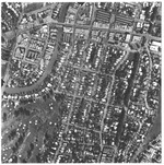
| Photograph, recto: [Aerial view of Stillwater drive and Biscayne Point] |

|
| Photograph, verso: Rader & Associates Engineers and Architects |
|
| Photograph, recto: [Aerial view of Biscaya Island, Stillwater drive and Biscayne Point] |

|
| Photograph, verso: Rader & Associates Engineers and Architects |

|
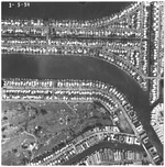
| Photograph, recto: [Aerial view of Biscaya Island, Indian Creek Island and Biscayne Point] |

|
| Photograph, verso: Rader & Associates Engineers and Architects |
|
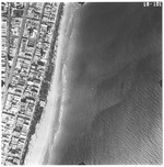
| Photograph, recto: [Aerial view of oceanfront buildings, beach and green spaces] |
|
| Photograph, verso: Rader & Associates Engineers and Architects |
|
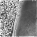
| Photograph, recto: [Aerial view of oceanfront buildings between 14th Street and 18th Street] |

|
| Photograph, verso: Rader & Associates Engineers and Architects |
|
| Photograph, recto: [Aerial view of oceanfront buildings between 16th Street and 23rd Street] |

|
| Photograph, verso: Rader & Associates Engineers and Architects |
|
| Photograph, recto: [Aerial view of oceanfront buildings between 18th Street and 26th Street. View of Pancoast Lake on the right] |

|
| Photograph, verso: Rader & Associates Engineers and Architects |
|
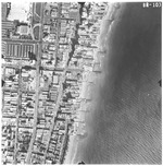
| Photograph, recto: [Aerial view of oceanfront buildings between 23rd Street and 26th Street] |

|
| Photograph, verso: Rader & Associates Engineers and Architects |
|
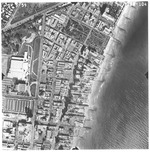
| Photograph, recto: [Aerial view of oceanfront buildings between 26th Street and 27th Street] |

|
| Photograph, verso: Rader & Associates Engineers and Architects |
|
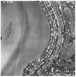
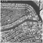
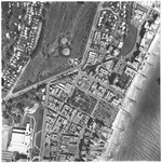
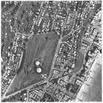
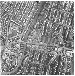
| Photograph, recto: [Aerial view of 41st Street bridge and the Miami Beach Municipal Golf Course] |

|
| Photograph, verso: Rader & Associates Engineers and Architects |
|
| Photograph, recto: [Aerial view of buildings around the 41st Street bridge] |

|
| Photograph, verso: Rader & Associates Engineers and Architects |
|
|


