|
|
|
|
   |
Go to thumbnail:
|
|
|
|
|
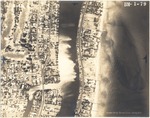
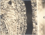
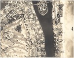
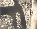
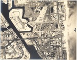
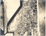
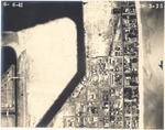
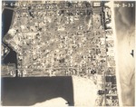
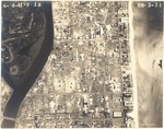
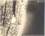
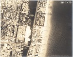
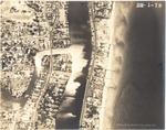
| Photograph, recto: [Aerial view of Indian Creek and Collins Ave at Flamingo Waterway and Pine Tree Drive] |
|
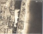
| Photograph, recto: Aerial Survey Map Abrams Aerial Survey Corp. Lansing, Michigan |
|
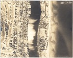
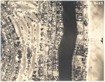
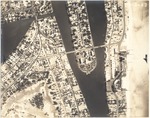
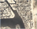
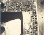
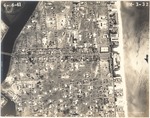
| Photograph, recto: [Aerial view of the La Gorce Country Club, Ocean front between 5100 block to 5700 block, and Indian Creek] |
|
| Photograph, recto: Aerial Survey Map Abrams Aerial Survey Corp. Lansing, Michigan |
|
| Photograph, recto: [Aerial view of the La Gorce Country Club, Ocean front between 5500 block to 6000 block, and Indian Creek] |
|
| Photograph, recto: Aerial Survey Map Abrams Aerial Survey Corp. Lansing, Michigan |
|
| Photograph, recto: [Aerial view of the La Gorce Country Club, Ocean front between 5250 block to 5750 block, and Indian Creek] |
|
| Photograph, recto: Aerial Survey Map Abrams Aerial Survey Corp. Lansing, Michigan |
|
| Photograph, recto: [Aerial view of the La Gorce Country Club, southern point of Allison Island and the 63rd Street bridge, and Indian Creek] |
|
| Photograph, recto: Aerial Survey Map Abrams Aerial Survey Corp. Lansing, Michigan |
|
| Photograph, recto: [Aerial view of the La Gorce Country Club, Allison Island and 63rd Street bridge] |
|
| Photograph, recto: Aerial Survey Map Abrams Aerial Survey Corp. Lansing, Michigan |

|
| Photograph, recto: [Aerial view of Allison Island and part of La Gorce Island] |
|
| Photograph, recto: Aerial Survey Map Abrams Aerial Survey Corp. Lansing, Michigan |
|
| Photograph, recto: [View of parts of La Gorce Island, Allison Island and Normandy Isle] |
|
| Photograph, recto: Aerial Survey Map Abrams Aerial Survey Corp. Lansing, Michigan |
|
| Photograph, recto: [Aerial view of the south east point of Normandy Isle and Normandy Drive] |
|
| Photograph, recto: Aerial Survey Map Abrams Aerial Survey Corp. Lansing, Michigan |
|
| Photograph, recto: [Aerial view of the south east point of Normandy Isle and Normandy Drive] |
|
| Photograph, recto: Aerial Survey Map Abrams Aerial Survey Corp. Lansing, Michigan |
|
| Photograph, recto: [Aerial view of Ocean front buildings between Twentieth Street and Twenty Six Street. View of Lake Pancoast on the left] |
|
| Photograph, recto: Aerial Survey Map Abrams Aerial Survey Corp. Lansing, Michigan |

|
| Photograph, recto: [Aerial view f Park View Island and Ocean front development] |
|
| Photograph, recto: Aerial Survey Map Abrams Aerial Survey Corp. Lansing, Michigan |
|
| Photograph, recto: [Aerial view of Tatum Waterway (formerly Atlantic waterway) up to 82nd Street] |
|
| Photograph, recto: Aerial Survey Map Abrams Aerial Survey Corp. Lansing, Michigan |
|
| Photograph, recto: [Aerial view of Tatum Waterway (formerly Atlantic waterway) up to today's 86th Street] |
|
| Photograph, recto: Aerial Survey Map Abrams Aerial Survey Corp. Lansing, Michigan |
|
| Photograph, recto: [View of Ocean front and Tantum Waterway between 81st Street and 87th Terrace] |
|
| Photograph, recto: Aerial Survey Map Abrams Aerial Survey Corp. Lansing, Michigan |
|
| Photograph, recto: [View of Ocean front between 84th Street and 87th Terrace] |
|
| Photograph, recto: Aerial Survey Map Abrams Aerial Survey Corp. Lansing, Michigan |
|
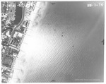
| Photograph, recto: [View of Ocean front between 85th Street and 93rd Street, City of Surfside and 91st Street bridge today] |
|
| Photograph, recto: Aerial Survey Map Abrams Aerial Survey Corp. Lansing, Michigan |
|
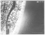
| Photograph, recto: [Aerial view of the City of Surfside (Fla.)] |
|
| Photograph, recto: Aerial Survey Map Abrams Aerial Survey Corp. Lansing, Michigan |

|
| Photograph, recto: [Aerial view of Ocean front buildings and view of Lake Pancoast] |
|
| Photograph, recto: Aerial Survey Map Abrams Aerial Survey Corp. Lansing, Michigan |
|
| Photograph, recto: [Aerial view of Ocean front buildings between Lake Pancoast 35th Street] |
|
| Photograph, recto: Aerial Survey Map Abrams Aerial Survey Corp. Lansing, Michigan |
|
| Photograph, recto: [Aerial view of Lake Pancoast] |
|
| Photograph, recto: Aerial Survey Map Abrams Aerial Survey Corp. Lansing, Michigan |

|
| Photograph, recto: [Aerial view of Ocean front buildings between 34st Street and 44 Street, including the Akeas Apartments, the Caribbean Hotel, the Hotel Intercontinental, the President Madison Hotel, the Versailles Hotel, the Taton hotel, the Archambo Hotel, the Alamo Hotel, the Coral Reef Hotel, the Pancoast Hotel, the Cornell Hotel and the Hotel Good] |
|
| Photograph, recto: Aerial Survey Map Abrams Aerial Survey Corp. Lansing, Michigan |
|
| Photograph, recto: [Aerial view of Ocean front buildings including the Nautilus Hotel and the Sunset Hotel, and the James H. Estate and Harley Firestone Estate] |
|
| Photograph, recto: Aerial Survey Map Abrams Aerial Survey Corp. Lansing, Michigan |
|
| Photograph, recto: [Aerial view of the James H. Snowden Estate, the Harvey Firestone purchased Snowden Estate, and the Johana Hailman Estate] |
|
| Photograph, recto: Aerial Survey Map Abrams Aerial Survey Corp. Lansing, Michigan |
|
| Photograph, recto: [Aerial view of Ocean front buildings and estates between 4600 Block and 5200 Block] |
|
| Photograph, recto: Aerial Survey Map Abrams Aerial Survey Corp. Lansing, Michigan |
|
|
|
|


