|
|
|
|
   |
Go to thumbnail:
|
|
|
|
|
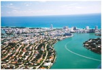
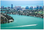
| Photograph, recto: [Aerial view of Normandy Isle to the left and La Gorce Island to the right] |

|
| Photograph, verso: [Blank] |
|
| Photograph, recto: [Aerial view of Normandy Isle looking east] |

|
| Photograph, verso: [Blank] |
|
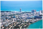
| Photograph, recto: [Aerial view of the Days Inn and apartment buildings in North Miami Beach] |
|
| Photograph, verso: [Blank] |
|
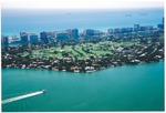
| Photograph, recto: [Aerial view of the Miami Beach Golf Club looking southeast from Biscayne Bay] |

|
| Photograph, verso: [Blank] |
|
| Photograph, recto: [Aerial view of the Miami Beach Golf Club looking southeast from Biscayne Bay. View of the Forty First Street bridge] |

|
| Photograph, verso: [Blank] |
|
| Photograph, recto: [Aerial view of Miami Beach from the Government Cut] |

|
| Photograph, verso: [Blank] |
|
| Photograph, recto: [Aerial view of Miami Beach from the Government Cut] |

|
| Photograph, verso: [Blank] |
|
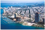
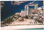
| Photograph, recto: [Aerial view of the Government Cut, South Pointe Park, Fisher Island, and the McArthur Causeway] |

|
| Photograph, verso |

|
| Photograph, recto: [Aerial view of the Port of Miami and the McArthur Causeway from the ocean] |

|
| Photograph, verso |
|
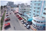
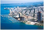
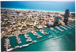
| Photograph, recto: [Aerial of the Miami Beach Marina and South Beach] |

|
| Photograph, verso |
|
|
|
|


